
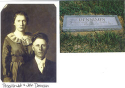
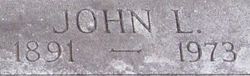
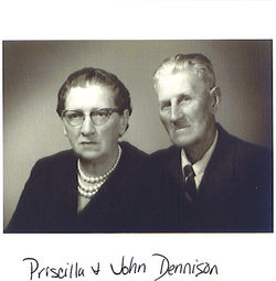
John Ludwig Sanderson Dennison
| Birth | : | 3 Sep 1891 Lyon County, Kansas, USA |
| Death | : | 2 Jul 1973 Topeka, Shawnee County, Kansas, USA |
| Burial | : | St Cuthberts Churchyard, Southport, Metropolitan Borough of Sefton, England |
| Coordinate | : | 53.6603230, -2.9620310 |
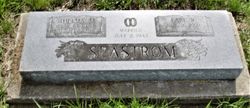
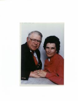
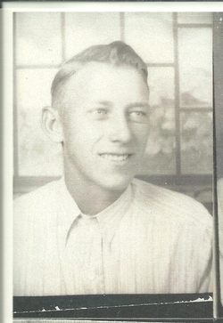
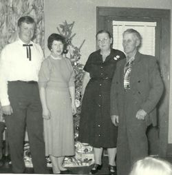
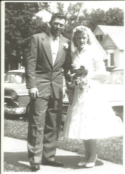
| Description | : | John Dennison John L. Dennison, 81, Burlingame, died Monday in a Topeka hospital where he ha been a patient since June 2. He had pneumonia. He was born Sept. 3, 1891, near Emporia and spent many years in the Carbondale community. He lived at Burlingame about 30 years. He was a farmer before he retired. He was married to Priscilla Job in 1919 at Carbondale. She survives. A son, Richard Lee Dennison, died in 1961. Other survivors include three daughters, Mrs. Thelma Seastrom, Burlingame, Mrs. Emma Morstorf, Silver Lake, and Mrs. Doris Burgess, Fredonia; three sons,... Read More |
frequently asked questions (FAQ):
-
Where is John Ludwig Sanderson Dennison's memorial?
John Ludwig Sanderson Dennison's memorial is located at: St Cuthberts Churchyard, Southport, Metropolitan Borough of Sefton, England.
-
When did John Ludwig Sanderson Dennison death?
John Ludwig Sanderson Dennison death on 2 Jul 1973 in Topeka, Shawnee County, Kansas, USA
-
Where are the coordinates of the John Ludwig Sanderson Dennison's memorial?
Latitude: 53.6603230
Longitude: -2.9620310
Family Members:
Parent
Spouse
Siblings

Children
Flowers:


Nearby Cemetories:
1. St Cuthberts Churchyard
Southport, Metropolitan Borough of Sefton, England
Coordinate: 53.6603230, -2.9620310
2. Emmanuel Parish Church
Southport, Metropolitan Borough of Sefton, England
Coordinate: 53.6604534, -2.9748117
3. Emmanuel Church Garden of Remembrance
North Meols, West Lancashire District, England
Coordinate: 53.6607130, -2.9753420
4. Saint John Crossens Churchyard
Crossens, Metropolitan Borough of Sefton, England
Coordinate: 53.6733410, -2.9478740
5. Holy Trinity Church
Southport, Metropolitan Borough of Sefton, England
Coordinate: 53.6503800, -2.9969150
6. St. Marie on the Sands
Southport, Metropolitan Borough of Sefton, England
Coordinate: 53.6524320, -3.0023440
7. St. Stephen's Churchyard
North Meols, West Lancashire District, England
Coordinate: 53.6813720, -2.9248140
8. Christ Church Churchyard
Southport, Metropolitan Borough of Sefton, England
Coordinate: 53.6327778, -2.9953770
9. Duke Street Cemetery
Southport, Metropolitan Borough of Sefton, England
Coordinate: 53.6343536, -2.9993131
10. Ardwick Cemetery
Ardwick, Metropolitan Borough of Manchester, England
Coordinate: 53.6302778, -2.9900000
11. Southport Crematorium
Scarisbrick, West Lancashire District, England
Coordinate: 53.6235810, -2.9600210
12. St. Mark Churchyard
Scarisbrick, West Lancashire District, England
Coordinate: 53.6134600, -2.9403800
13. St. Elizabeth's Churchyard
Scarisbrick, West Lancashire District, England
Coordinate: 53.6124460, -2.9206340
14. Liverpool Road Cemetery
Birkdale, Metropolitan Borough of Sefton, England
Coordinate: 53.6083620, -3.0257140
15. Sacred Heart RC Cemetery
Birkdale, Metropolitan Borough of Sefton, England
Coordinate: 53.6066100, -3.0270100
16. St. Cuthbert's Churchyard
Halsall, West Lancashire District, England
Coordinate: 53.5852140, -2.9529650
17. St John the Divine
Lytham Saint Annes, Fylde Borough, England
Coordinate: 53.7367060, -2.9548070
18. St. Cuthbert Churchyard
Lytham Saint Annes, Fylde Borough, England
Coordinate: 53.7376560, -2.9761270
19. St. Mary's Churchyard
Tarleton, West Lancashire District, England
Coordinate: 53.6746100, -2.8239200
20. All Saints Churchyard
Hesketh with Becconsall, West Lancashire District, England
Coordinate: 53.7028189, -2.8400142
21. Saltcoates Roman Catholic Cemetery
Lytham Saint Annes, Fylde Borough, England
Coordinate: 53.7463000, -2.9448940
22. West Lancashire Cemetery and Crematorium
Burscough, West Lancashire District, England
Coordinate: 53.5875500, -2.8820300
23. Becconsall Old Church Churchyard
Hesketh with Becconsall, West Lancashire District, England
Coordinate: 53.7023610, -2.8314810
24. St John the Baptist Churchyard
Burscough, West Lancashire District, England
Coordinate: 53.6042760, -2.8401390