

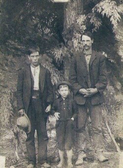
John Mack Herron
| Birth | : | 7 Sep 1872 Alarka, Swain County, North Carolina, USA |
| Death | : | 12 Aug 1956 Marion, McDowell County, North Carolina, USA |
| Burial | : | Bethlehem Lutheran West Cemetery, Ulen Township, Clay County, USA |
| Coordinate | : | 47.0783600, -96.2803800 |
| Description | : | John Mack Herron was the son of Mary Herron and Finnis Mathis "Finney" Marsengill. He married Amanda Jane Hummer on 11 May 1899 in Swain Co, NC. John and Amanda had 7-children: * William Coleman Herron (1902-1965) * Fred Verlon Herron (1905-1992) * John Henry Herron (1906-1996) * Lee Glenn Ben Herron (1909-1976) * Mae Elizabeth Herron (1911-2003) * Kelly M Herron (1914-1977) * Herschel Herron 20 Mar 1926 After the death of Amanda on 20 Mar 1926, John Mack married Bertha Mae "Birdie" Bridges on 20 Sep 1928 in Swain Co, NC. John and Birdie had 11-children: * David Delmar Herron * Troy Lee Herron (1929- ) *... Read More |
frequently asked questions (FAQ):
-
Where is John Mack Herron's memorial?
John Mack Herron's memorial is located at: Bethlehem Lutheran West Cemetery, Ulen Township, Clay County, USA.
-
When did John Mack Herron death?
John Mack Herron death on 12 Aug 1956 in Marion, McDowell County, North Carolina, USA
-
Where are the coordinates of the John Mack Herron's memorial?
Latitude: 47.0783600
Longitude: -96.2803800
Family Members:
Parent
Spouse
Siblings

Children
Flowers:


Nearby Cemetories:
1. Bethlehem Lutheran West Cemetery
Ulen Township, Clay County, USA
Coordinate: 47.0783600, -96.2803800
2. Creamery Cemetery
Ulen, Clay County, USA
Coordinate: 47.0785820, -96.2587730
3. Sliper Cemetery
Ulen Township, Clay County, USA
Coordinate: 47.0931015, -96.2656021
4. Calvary Lutheran Cemetery
Ulen Township, Clay County, USA
Coordinate: 47.0907100, -96.2587100
5. Bethlehem Memorial Cemetery
Ulen Township, Clay County, USA
Coordinate: 47.0915900, -96.2588000
6. Keene Lutheran Cemetery
Keene Township, Clay County, USA
Coordinate: 47.0354400, -96.3650300
7. Old Jevnaker Cemetery
Hagen Township, Clay County, USA
Coordinate: 47.1441710, -96.3515780
8. Salem West Cemetery
Hitterdal, Clay County, USA
Coordinate: 46.9757300, -96.2600000
9. United Norwegian Lutheran Cemetery
Rockwell Township, Norman County, USA
Coordinate: 47.1652778, -96.3647222
10. Atlanta Cemetery
Atlanta Township, Becker County, USA
Coordinate: 47.0522300, -96.1314440
11. Salem East Cemetery
Hitterdal, Clay County, USA
Coordinate: 46.9744800, -96.2583300
12. Jevnaker Cemetery
Rockwell Township, Norman County, USA
Coordinate: 47.1514015, -96.3953018
13. Walworth Baptist Cemetery
Walworth Township, Becker County, USA
Coordinate: 47.1404600, -96.1517000
14. Syre Cemetery
Syre, Norman County, USA
Coordinate: 47.1869090, -96.2592670
15. Old Aspelund Church Cemetery
Flom Township, Norman County, USA
Coordinate: 47.1519610, -96.1300710
16. Aspelund Lutheran Church Cemetery
Flom Township, Norman County, USA
Coordinate: 47.1574300, -96.1315480
17. Lysne Cemetery
Cromwell Township, Clay County, USA
Coordinate: 46.9639015, -96.3752975
18. Immanuel Lutheran Cemetery
Flom Township, Norman County, USA
Coordinate: 47.1894455, -96.1725006
19. Buffalo River Pioneer Cemetery
Cuba Township, Becker County, USA
Coordinate: 46.9650250, -96.1737160
20. Highland Grove Lutheran Cemetery
Highland Grove Township, Clay County, USA
Coordinate: 46.9518700, -96.2113500
21. Felton Cemetery
Felton Township, Clay County, USA
Coordinate: 47.0643997, -96.4993973
22. East Wild Rice Lutheran Cemetery
Flom Township, Norman County, USA
Coordinate: 47.2244200, -96.1742980
23. Dale Immanuel Cemetery
Highland Grove Township, Clay County, USA
Coordinate: 46.9171982, -96.2169037
24. Bethlehem Cemetery
Flom Township, Norman County, USA
Coordinate: 47.2244660, -96.1306220