
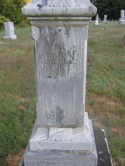
John Namon Redifer
| Birth | : | 22 Jun 1842 Augusta County, Virginia, USA |
| Death | : | 16 Dec 1923 Riley, Vigo County, Indiana, USA |
| Burial | : | Orangeville Cemetery, Orangeville, Stephenson County, USA |
| Coordinate | : | 42.4725100, -89.6444300 |
| Description | : | History of Clay County, Indiana,Page's 292,293. Prominent among the enterprising and progressive agriculturists of Clay county is John N. Redifer, who is successfully engaged in his independent calling in Perry Township,having a finely improved and well ,managed farm. A son of Charles L. Redifer he was born June 22, 1842, in Augusta County, Virginia where the first six years of his life were spent. But ten years old when he came to Clay county with his father. John N. Redifer began two years later to become self- supporting, for a number of years thereafter working as a farm laborer. In... Read More |
frequently asked questions (FAQ):
-
Where is John Namon Redifer's memorial?
John Namon Redifer's memorial is located at: Orangeville Cemetery, Orangeville, Stephenson County, USA.
-
When did John Namon Redifer death?
John Namon Redifer death on 16 Dec 1923 in Riley, Vigo County, Indiana, USA
-
Where are the coordinates of the John Namon Redifer's memorial?
Latitude: 42.4725100
Longitude: -89.6444300
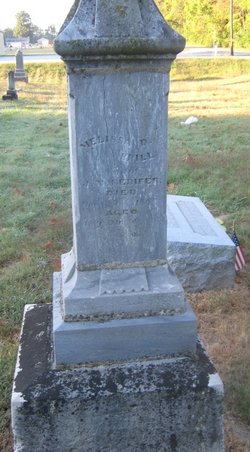
Family Members:
Parent
Spouse
Siblings
Children
Flowers:


Nearby Cemetories:
1. Orangeville Cemetery
Orangeville, Stephenson County, USA
Coordinate: 42.4725100, -89.6444300
2. Sunset Acres Cemetery
Orangeville, Stephenson County, USA
Coordinate: 42.4734200, -89.6347200
3. Eldorado Cemetery
Orangeville, Stephenson County, USA
Coordinate: 42.4831009, -89.6136017
4. Oneco Cemetery
Stephenson County, USA
Coordinate: 42.4930992, -89.6688995
5. Bowen Family Homestead Cemetery
Clarno, Green County, USA
Coordinate: 42.5081600, -89.6713300
6. Saint James Cemetery
Stephenson County, USA
Coordinate: 42.4592018, -89.7005997
7. West Clarno Pioneer Cemetery
Clarno, Green County, USA
Coordinate: 42.5190000, -89.6535400
8. East Clarno Cemetery
Clarno, Green County, USA
Coordinate: 42.5190500, -89.6208400
9. Zion Cemetery
Buckeye Township, Stephenson County, USA
Coordinate: 42.4210400, -89.6379800
10. Mount Pleasant Cemetery
Oneco, Stephenson County, USA
Coordinate: 42.4907990, -89.7144012
11. Bellview Cemetery
Stephenson County, USA
Coordinate: 42.4166985, -89.6524963
12. Salem Shippee McConnell Cemetery
McConnell, Stephenson County, USA
Coordinate: 42.4402700, -89.7074300
13. Johnson Cemetery
Twin Grove, Green County, USA
Coordinate: 42.5031013, -89.5783005
14. Basswood Cemetery
McConnell, Stephenson County, USA
Coordinate: 42.4659700, -89.7311500
15. Richland Salem Lutheran Cemetery
McConnell, Stephenson County, USA
Coordinate: 42.4251100, -89.7070900
16. Afolkey Cemetery
Afolkey, Stephenson County, USA
Coordinate: 42.4289017, -89.5759506
17. Old Pioneer Cemetery
Clarno, Green County, USA
Coordinate: 42.5267500, -89.7003400
18. Richland Center Cemetery
Buckeye Township, Stephenson County, USA
Coordinate: 42.4095600, -89.6892100
19. Silent Hill Cemetery
McConnell, Stephenson County, USA
Coordinate: 42.4328003, -89.7244034
20. McConnell Cemetery
McConnell, Stephenson County, USA
Coordinate: 42.4355600, -89.7285300
21. Staver Church Cemetery
Clarno, Green County, USA
Coordinate: 42.5201100, -89.7192800
22. Figi Farm Cemetery
Clarno, Green County, USA
Coordinate: 42.5420900, -89.7056700
23. Rock Grove Cemetery
Rock Grove, Stephenson County, USA
Coordinate: 42.4688988, -89.5294037
24. Cedarville Cemetery
Cedarville, Stephenson County, USA
Coordinate: 42.3838997, -89.6410980