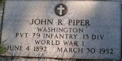
John Ralph Piper
| Birth | : | 4 Jun 1892 Palisade, Hitchcock County, Nebraska, USA |
| Death | : | 30 Mar 1952 Coulee Dam, Okanogan County, Washington, USA |
| Burial | : | Havelock North Cemetery, Havelock North, Hastings District, New Zealand |
| Coordinate | : | -39.6789900, 176.8802700 |
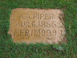
| Description | : | Washington Death Certificate Name John Ralph Piper Death date 30 Mar 1952 Death place Coulee Dam, Okanogan, Washington Gender Male Age at death 59 years Estimated birth year 1893 Father name Alonso Albert Piper Mother name Sara Francis Crawfard Film number 2033086 Digital GS number 4224250 Image number 1864 Reference number 4765 |
frequently asked questions (FAQ):
-
Where is John Ralph Piper's memorial?
John Ralph Piper's memorial is located at: Havelock North Cemetery, Havelock North, Hastings District, New Zealand.
-
When did John Ralph Piper death?
John Ralph Piper death on 30 Mar 1952 in Coulee Dam, Okanogan County, Washington, USA
-
Where are the coordinates of the John Ralph Piper's memorial?
Latitude: -39.6789900
Longitude: 176.8802700
Family Members:
Parent
Spouse
Siblings
Flowers:
Nearby Cemetories:
1. Havelock North Cemetery
Havelock North, Hastings District, New Zealand
Coordinate: -39.6789900, 176.8802700
2. Waipatu Cemetery
Hastings District, New Zealand
Coordinate: -39.6305400, 176.8718050
3. Ruahapia Cemetery
Hastings District, New Zealand
Coordinate: -39.6205700, 176.8776420
4. Hastings Cemetery and Crematorium
Camberley, Hastings District, New Zealand
Coordinate: -39.6310310, 176.8252840
5. Whenuakura Cemetery
Pakipaki, Hastings District, New Zealand
Coordinate: -39.6951080, 176.7969270
6. Parahaki Cemetery
Pakipaki, Hastings District, New Zealand
Coordinate: -39.6979349, 176.7902852
7. Mangaroa Cemetery
Hastings, Hastings District, New Zealand
Coordinate: -39.6670580, 176.7829920
8. Te Pakiaka Cemetery
Tomoana, Hastings District, New Zealand
Coordinate: -39.6027380, 176.8755680
9. Matahiwi Urupā
Hastings, Hastings District, New Zealand
Coordinate: -39.6079120, 176.9242550
10. Pakowhai Cemetery
Clive, Hastings District, New Zealand
Coordinate: -39.5987860, 176.8758800
11. Kohupatiki Cemetery
Clive, Hastings District, New Zealand
Coordinate: -39.5980640, 176.9014900
12. Korongata Cemetery
Hastings District, New Zealand
Coordinate: -39.6491440, 176.7576760
13. Waiohiki Urupā
Waiohiki, Hastings District, New Zealand
Coordinate: -39.5543200, 176.8355100
14. Omahu Urupā
Fernhill, Hastings District, New Zealand
Coordinate: -39.5830024, 176.7604719
15. Waimarama Cemetery
Waimarama, Hastings District, New Zealand
Coordinate: -39.8070690, 176.9870000
16. Taradale Cemetery
Taradale, Napier City, New Zealand
Coordinate: -39.5302500, 176.8365200
17. The Hera Te Upokoiri Urupa (Princess Sarah)
Hastings District, New Zealand
Coordinate: -39.6481600, 176.6748570
18. Runanga Cemetery
Hastings District, New Zealand
Coordinate: -39.5659710, 176.7153880
19. Te Hauke Urupā
Te Hauke, Hastings District, New Zealand
Coordinate: -39.7727100, 176.6897100
20. Park Island Cemetery
Napier, Napier City, New Zealand
Coordinate: -39.5037900, 176.8552400
21. Wharerangi Lawn Cemetery
Napier, Napier City, New Zealand
Coordinate: -39.5024809, 176.8500951
22. Western Hills Cemetery
Napier, Napier City, New Zealand
Coordinate: -39.5019130, 176.8548630
23. Puketapu Cemetery
Puketapu, Hastings District, New Zealand
Coordinate: -39.5111350, 176.7890810
24. Moteo Cemetery
Moteo, Hastings District, New Zealand
Coordinate: -39.5180124, 176.7650106


