
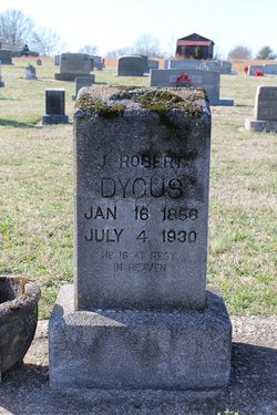
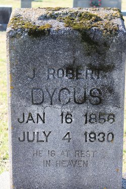
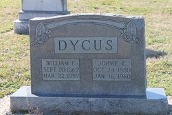
John Robert Dycus
| Birth | : | 16 Jan 1856 Rutherford County, North Carolina, USA |
| Death | : | 4 Jul 1930 Rutherford County, North Carolina, USA |
| Burial | : | Jordan Chapel Cemetery, Dix, Jefferson County, USA |
| Coordinate | : | 38.4463997, -88.9175034 |
frequently asked questions (FAQ):
-
Where is John Robert Dycus's memorial?
John Robert Dycus's memorial is located at: Jordan Chapel Cemetery, Dix, Jefferson County, USA.
-
When did John Robert Dycus death?
John Robert Dycus death on 4 Jul 1930 in Rutherford County, North Carolina, USA
-
Where are the coordinates of the John Robert Dycus's memorial?
Latitude: 38.4463997
Longitude: -88.9175034
Family Members:
Parent

Siblings
Children
Flowers:


Nearby Cemetories:
1. Jordan Chapel Cemetery
Dix, Jefferson County, USA
Coordinate: 38.4463997, -88.9175034
2. Antioch Cemetery
Dix, Jefferson County, USA
Coordinate: 38.4400700, -88.9032700
3. Six Graves Cemetery
Rome Township, Jefferson County, USA
Coordinate: 38.4447600, -88.9573100
4. Gilead Cemetery
Rome Township, Jefferson County, USA
Coordinate: 38.4446983, -88.9599991
5. Zion Grove Cemetery
Kell, Marion County, USA
Coordinate: 38.4766998, -88.9421997
6. Pleasant Hill Cemetery
Dix, Jefferson County, USA
Coordinate: 38.4106700, -88.9323000
7. Jennings Farm Cemetery
Mount Vernon, Jefferson County, USA
Coordinate: 38.4133825, -88.9467310
8. Baldridge Cemetery
Rome Township, Jefferson County, USA
Coordinate: 38.4251600, -88.9708330
9. Hickey Cemetery
Jefferson County, USA
Coordinate: 38.4622002, -88.8557968
10. Oak Grove Cemetery
Idlewood, Jefferson County, USA
Coordinate: 38.4067001, -88.8739014
11. Panther Fork Cemetery
Texico, Jefferson County, USA
Coordinate: 38.4497100, -88.8478100
12. Union Chapel Cemetery
Texico, Jefferson County, USA
Coordinate: 38.4323000, -88.8470000
13. Ebenezer Cemetery
Jefferson County, USA
Coordinate: 38.3969002, -88.9563980
14. Simmons Cemetery
Texico, Jefferson County, USA
Coordinate: 38.4511000, -88.8433000
15. Hall Cemetery
Jefferson County, USA
Coordinate: 38.4627991, -88.8419037
16. Hopewell Cemetery
Idlewood, Jefferson County, USA
Coordinate: 38.3857390, -88.8813330
17. S J Simmons Graveyard
Divide, Jefferson County, USA
Coordinate: 38.4477107, -88.8317201
18. Old Covenanter Cemetery
Centralia, Marion County, USA
Coordinate: 38.4838982, -88.9903030
19. Purdue Cemetery
Kell, Marion County, USA
Coordinate: 38.5116997, -88.8831024
20. Pleasant Grove Cemetery
Mount Vernon, Jefferson County, USA
Coordinate: 38.3736790, -88.9248060
21. Hall-Stonecipher Cemetery
Kell, Marion County, USA
Coordinate: 38.5110168, -88.8712463
22. Romine Prairie Cemetery
Marion County, USA
Coordinate: 38.5200005, -88.9458008
23. Boyd Farm Cemetery
Boyd, Jefferson County, USA
Coordinate: 38.4135900, -89.0076500
24. Boyd Cemetery
Boyd, Jefferson County, USA
Coordinate: 38.4184800, -89.0140900