
| Birth | : | 14 Jan 1908 Miles City, Custer County, Montana, USA |
| Death | : | 28 Aug 1976 Miles City, Custer County, Montana, USA |
| Burial | : | Valley View Cemetery, Broadus, Powder River County, USA |
| Coordinate | : | 45.4505997, -105.4011002 |
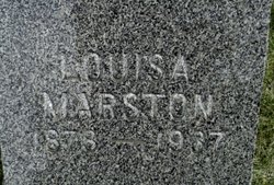
| Description | : | "BROADUS -- John R. 'Bim' Marston, 68, of Powderville, died Saturday morning at Holy Rosary Hospital after a long illness. He was born Jan. 14, 1908, in Miles City, the son of Percy and Louisa Marston. He attended schools in Powderville and Miles City. He then worked on various ranches in the Powderville area. He married Eleanor Broaddus on Sept. 30, 1939, in Broadus. They made their home in Powderville. He served as Powderville postmaster for 35 years and deputy stock inspector for 25 years. He was a member of the... Read More |
frequently asked questions (FAQ):
-
Where is John Roper “Bim” Marston's memorial?
John Roper “Bim” Marston's memorial is located at: Valley View Cemetery, Broadus, Powder River County, USA.
-
When did John Roper “Bim” Marston death?
John Roper “Bim” Marston death on 28 Aug 1976 in Miles City, Custer County, Montana, USA
-
Where are the coordinates of the John Roper “Bim” Marston's memorial?
Latitude: 45.4505997
Longitude: -105.4011002
Family Members:
Parent

Spouse
Siblings
Flowers:


Nearby Cemetories:
1. Valley View Cemetery
Broadus, Powder River County, USA
Coordinate: 45.4505997, -105.4011002
2. Broaddus Family Cemetery
Powder River County, USA
Coordinate: 45.2839849, -105.5906104
3. Powder River Memorial Cemetery
Broadus, Powder River County, USA
Coordinate: 45.2532799, -105.6266420
4. Yarger Cemetery
Powder River County, USA
Coordinate: 45.2531013, -105.6691971
5. Twin Pine Cemetery
Sonnette, Powder River County, USA
Coordinate: 45.3665600, -105.8292100
6. Boyes Cemetery
Carter County, USA
Coordinate: 45.3069000, -105.0025024
7. Boothill Cemetery
Powder River County, USA
Coordinate: 45.7592010, -105.1239014
8. Ranch Creek Cemetery
Powder River County, USA
Coordinate: 45.0466995, -105.1782990
9. North Stacey Cemetery
Powder River County, USA
Coordinate: 45.7569008, -105.8814011
10. Powder River Battlefield Soldiers Monument
Powder River County, USA
Coordinate: 45.0977403, -105.8544210
11. Drane Cemetery
Ridge, Carter County, USA
Coordinate: 45.0493990, -105.0167710
12. Ridge Cemetery
Carter County, USA
Coordinate: 45.0261002, -105.0346985
13. Trenk Family Plot
Ekalaka, Carter County, USA
Coordinate: 45.7325000, -104.7083333
14. Willow Crossing Cemetery
Powder River County, USA
Coordinate: 45.5382996, -106.1931000
15. Rockypoint Cemetery
Rockypoint, Campbell County, USA
Coordinate: 44.9153000, -105.0859000
16. Ashland Cemetery
Ashland, Rosebud County, USA
Coordinate: 45.5867170, -106.2645560
17. ER Cemetery
Weston, Campbell County, USA
Coordinate: 44.9385000, -105.9333000
18. Saint Labre Cemetery
Ashland, Rosebud County, USA
Coordinate: 45.6070930, -106.2836910
19. Ewalt Cemetery
Ridgeway, Carter County, USA
Coordinate: 45.4908333, -104.4786111
20. Dufford Cemetery
Powder River County, USA
Coordinate: 45.1091995, -106.2316971
21. MacKenzie Family Cemetery
Custer County, USA
Coordinate: 46.1569500, -105.1448000
22. Beaver Lodge Cemetery
Ekalaka, Carter County, USA
Coordinate: 45.8847008, -104.5522003
23. Recluse Cemetery
Recluse, Campbell County, USA
Coordinate: 44.7413000, -105.7176000
24. Russell Cemetery
Carter County, USA
Coordinate: 45.8292007, -104.4681015