
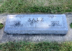
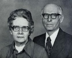
John Salz
| Birth | : | 26 Jan 1890 Leonore, LaSalle County, Illinois, USA |
| Death | : | 13 Jul 1957 Osage, Mitchell County, Iowa, USA |
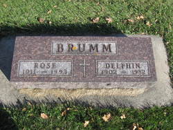
| Burial | : | Sacred Heart Cemetery, Osage, Mitchell County, USA |
| Coordinate | : | 43.2742004, -92.7917023 |
| Description | : | JOHN SALZ, 67, DIES; FUNERAL AT OSAGE CHURCH Osage – Funeral services will be conducted at 9 a.m. Tuesday at the Sacred Heart Catholic Church here for John Salz, 67. He died at midnight Saturday at Mitchell County Memorial Hospital where he had been hospitalized for the past eight weeks with a heart condition. Mr. Salz was born at Leonore, Illinois on January 26, 1890, to John and Elizabeth Salz. In 1908 he accompanied his family to a farm near Little Cedar. He was married to Anna Wiesbrock in 1918. They lived on a farm near Stacyville, retiring to Osage... Read More |
frequently asked questions (FAQ):
-
Where is John Salz's memorial?
John Salz's memorial is located at: Sacred Heart Cemetery, Osage, Mitchell County, USA.
-
When did John Salz death?
John Salz death on 13 Jul 1957 in Osage, Mitchell County, Iowa, USA
-
Where are the coordinates of the John Salz's memorial?
Latitude: 43.2742004
Longitude: -92.7917023
Family Members:
Parent
Spouse

Siblings
Children
Flowers:


Nearby Cemetories:
1. Sacred Heart Cemetery
Osage, Mitchell County, USA
Coordinate: 43.2742004, -92.7917023
2. South Osage Mennonite Church Cemetery
Osage, Mitchell County, USA
Coordinate: 43.2544556, -92.7915573
3. Osage Cemetery
Osage, Mitchell County, USA
Coordinate: 43.2916700, -92.8201700
4. Tucker Cemetery
Osage, Mitchell County, USA
Coordinate: 43.2494011, -92.8319016
5. Orchard Cemetery
Orchard, Mitchell County, USA
Coordinate: 43.2249985, -92.7838898
6. Calvary Cemetery
Osage, Mitchell County, USA
Coordinate: 43.2238998, -92.8300018
7. Oak Grove Cemetery
Mitchell, Mitchell County, USA
Coordinate: 43.3156013, -92.8707962
8. Dudley Cemetery
Dudley (historical), Mitchell County, USA
Coordinate: 43.2252998, -92.8743973
9. Rock Creek Cemetery
Meroa, Mitchell County, USA
Coordinate: 43.2352791, -92.9225006
10. Stillwater Cemetery
Orchard, Mitchell County, USA
Coordinate: 43.2130585, -92.6780624
11. Eden Presbyterian Cemetery
Meroa, Mitchell County, USA
Coordinate: 43.2131004, -92.9103012
12. Beaver Creek Cemetery
Brownville, Mitchell County, USA
Coordinate: 43.3397217, -92.6727829
13. Saint Peters Cemetery
New Haven, Mitchell County, USA
Coordinate: 43.2858315, -92.6427765
14. Howardville Cemetery
Floyd, Floyd County, USA
Coordinate: 43.1866989, -92.7016983
15. West End Cemetery
Meroa, Mitchell County, USA
Coordinate: 43.2216682, -92.9250031
16. Riverview Cemetery
Saint Ansgar, Mitchell County, USA
Coordinate: 43.3430328, -92.9220200
17. Liberty Cemetery
Little Cedar, Mitchell County, USA
Coordinate: 43.3856010, -92.7230988
18. Saint Ansgar Cemetery
Saint Ansgar, Mitchell County, USA
Coordinate: 43.3777809, -92.9094391
19. Immanuel Lutheran Cemetery
Saint Ansgar, Mitchell County, USA
Coordinate: 43.3717003, -92.9257965
20. First Lutheran Cemetery
Saint Ansgar, Mitchell County, USA
Coordinate: 43.3841705, -92.9194412
21. Blakestad Cemetery
Saint Ansgar, Mitchell County, USA
Coordinate: 43.3711014, -92.9400024
22. Saint Johns Lutheran Cemetery
Rock Creek, Mitchell County, USA
Coordinate: 43.3295560, -92.9849770
23. Saint Johns Lutheran Old Cemetery
Rock Creek, Mitchell County, USA
Coordinate: 43.3313904, -92.9897232
24. Stacyville Cemetery
Stacyville, Mitchell County, USA
Coordinate: 43.4294014, -92.7908020