
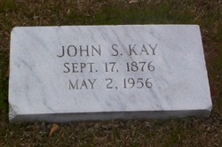

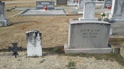
John Sanford Palmer Kay
| Birth | : | 17 Sep 1876 Anderson, Anderson County, South Carolina, USA |
| Death | : | 2 May 1956 Anderson, Anderson County, South Carolina, USA |
| Burial | : | Mountain City Cemetery, McClusky, Sheridan County, USA |
| Coordinate | : | 47.5677567, -100.5018082 |
| Plot | : | Southside |
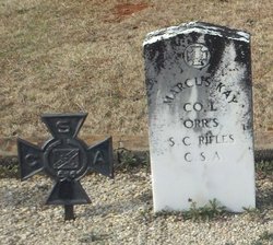
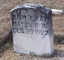
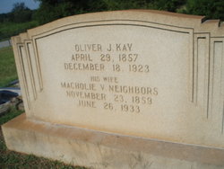
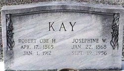
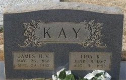
| Description | : | John Sanford Kay (1876-1956) was the son of Marcus Moore Kay (1835-1924), a veteran of the War Between the States, and Mary Angeline Campbell (1935-1927), who are buried at Whitefield Baptist Church Cemetery in Anderson County, SC. Marcus Moore Kay's parents were Charles Kay (1790-1867), a planter with substanial acreage, and his first wife Mary Johnson Kay (1797-1860), both buried at the Charles Kay Private Cemetery near Whitefield Baptist Church. Anderson County, SC. In 1898 John Sanford Kay married Ida Matilda Mann b. 10 March 1877 the daughter of Alfred K. Mann and Margaret McCoy Mann. Matilda Mann... Read More |
frequently asked questions (FAQ):
-
Where is John Sanford Palmer Kay's memorial?
John Sanford Palmer Kay's memorial is located at: Mountain City Cemetery, McClusky, Sheridan County, USA.
-
When did John Sanford Palmer Kay death?
John Sanford Palmer Kay death on 2 May 1956 in Anderson, Anderson County, South Carolina, USA
-
Where are the coordinates of the John Sanford Palmer Kay's memorial?
Latitude: 47.5677567
Longitude: -100.5018082
Family Members:
Parent
Spouse
Siblings


Nearby Cemetories:
1. Mountain City Cemetery
McClusky, Sheridan County, USA
Coordinate: 47.5677567, -100.5018082
2. Westheim Cemetery
Sheridan County, USA
Coordinate: 47.5421982, -100.4807968
3. Seventh Day Adventist Conference Cemetery
McClusky, Sheridan County, USA
Coordinate: 47.5598340, -100.4595420
4. Evangelical United Brethren Cemetery
McClusky, Sheridan County, USA
Coordinate: 47.6184450, -100.4958980
5. Hieb-Huft Cemetery
McClusky, Sheridan County, USA
Coordinate: 47.6029100, -100.3952700
6. Hoffer-Krein Cemetery
McClusky, Sheridan County, USA
Coordinate: 47.6240768, -100.4155426
7. Hegel Family Cemetery
Sheridan County, USA
Coordinate: 47.6478650, -100.5470790
8. Holy Family Catholic Cemetery
McClusky, Sheridan County, USA
Coordinate: 47.4807854, -100.4375076
9. McClusky City Cemetery
McClusky, Sheridan County, USA
Coordinate: 47.4801178, -100.4373550
10. Lincoln Valley Seventh-Day Adventist Cemetery
Lincoln Valley, Sheridan County, USA
Coordinate: 47.6179466, -100.3515167
11. Holy Ghost Lutheran Cemetery
Sheridan County, USA
Coordinate: 47.7028008, -100.4672012
12. Our Savior Cemetery
McLean County, USA
Coordinate: 47.5894012, -100.7149963
13. West Scandia Cemetery
Sheridan County, USA
Coordinate: 47.6925011, -100.3902969
14. Emmanuel Lutheran Cemetery
Sheridan County, USA
Coordinate: 47.6736526, -100.6597443
15. Mercer Hillside Cemetery
Mercer, McLean County, USA
Coordinate: 47.4932300, -100.7062000
16. First German Baptist Church Cemetery
McClusky, Sheridan County, USA
Coordinate: 47.4450684, -100.3536987
17. Lincoln Valley Baptist Cemetery
Lincoln Valley, Sheridan County, USA
Coordinate: 47.6469688, -100.2972870
18. Lincoln Valley Lutheran Cemetery
Lincoln Valley, Sheridan County, USA
Coordinate: 47.6722527, -100.3097916
19. Medicine Hill Cemetery
McLean County, USA
Coordinate: 47.5966988, -100.7574997
20. Kassel Reformed Church Cemetery
Lincoln Valley, Sheridan County, USA
Coordinate: 47.6878431, -100.3061804
21. Denhoff Catholic Cemetery
Denhoff, Sheridan County, USA
Coordinate: 47.4853247, -100.2673544
22. Denhoff Cemetery
Denhoff, Sheridan County, USA
Coordinate: 47.4839973, -100.2679291
23. Tabor Cemetery
McLean County, USA
Coordinate: 47.6546100, -100.7483600
24. Edgmont Township Cemetery
Sheridan County, USA
Coordinate: 47.3852997, -100.5875168