

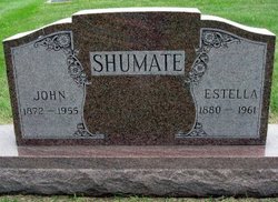
John Shumate
| Birth | : | 10 Jan 1872 Missouri, USA |
| Death | : | 3 Jun 1955 Austin, Mower County, Minnesota, USA |
| Burial | : | Osage Cemetery, Osage, Mitchell County, USA |
| Coordinate | : | 43.2916700, -92.8201700 |
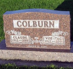
| Description | : | John Shumate 1872-1955 #1 MRS. COLBURN'S FATHER John Shumate, father of Mrs. Claude Colburn of near Ionia, died early Friday morning at the St. Olaf Hospital in Austin, Minnesota. Death was caused from an ailment and complications of old age. Mr. Shumate was 83 years old. He lived several years in and around the vicinity of Fredericksburg, before moving to Minnesota. Nashua Reporter, Thursday June 9, 1955 #2 Minnesota Death Index: Name: John Shumate Birth Date: 10 Jan 1872 ; Death Date: 3 Jun 1955 Death County: Mower ; Mother's Maiden Name: Baskett State File Number: 009667 ; Certificate Number: 009667 Certificate Year:... Read More |
frequently asked questions (FAQ):
-
Where is John Shumate's memorial?
John Shumate's memorial is located at: Osage Cemetery, Osage, Mitchell County, USA.
-
When did John Shumate death?
John Shumate death on 3 Jun 1955 in Austin, Mower County, Minnesota, USA
-
Where are the coordinates of the John Shumate's memorial?
Latitude: 43.2916700
Longitude: -92.8201700
Family Members:
Parent
Spouse
Siblings
Children

Flowers:


Nearby Cemetories:
1. Osage Cemetery
Osage, Mitchell County, USA
Coordinate: 43.2916700, -92.8201700
2. Sacred Heart Cemetery
Osage, Mitchell County, USA
Coordinate: 43.2742004, -92.7917023
3. South Osage Mennonite Church Cemetery
Osage, Mitchell County, USA
Coordinate: 43.2544556, -92.7915573
4. Tucker Cemetery
Osage, Mitchell County, USA
Coordinate: 43.2494011, -92.8319016
5. Oak Grove Cemetery
Mitchell, Mitchell County, USA
Coordinate: 43.3156013, -92.8707962
6. Calvary Cemetery
Osage, Mitchell County, USA
Coordinate: 43.2238998, -92.8300018
7. Orchard Cemetery
Orchard, Mitchell County, USA
Coordinate: 43.2249985, -92.7838898
8. Dudley Cemetery
Dudley (historical), Mitchell County, USA
Coordinate: 43.2252998, -92.8743973
9. Riverview Cemetery
Saint Ansgar, Mitchell County, USA
Coordinate: 43.3430328, -92.9220200
10. Rock Creek Cemetery
Meroa, Mitchell County, USA
Coordinate: 43.2352791, -92.9225006
11. Eden Presbyterian Cemetery
Meroa, Mitchell County, USA
Coordinate: 43.2131004, -92.9103012
12. West End Cemetery
Meroa, Mitchell County, USA
Coordinate: 43.2216682, -92.9250031
13. Saint Ansgar Cemetery
Saint Ansgar, Mitchell County, USA
Coordinate: 43.3777809, -92.9094391
14. Immanuel Lutheran Cemetery
Saint Ansgar, Mitchell County, USA
Coordinate: 43.3717003, -92.9257965
15. First Lutheran Cemetery
Saint Ansgar, Mitchell County, USA
Coordinate: 43.3841705, -92.9194412
16. Liberty Cemetery
Little Cedar, Mitchell County, USA
Coordinate: 43.3856010, -92.7230988
17. Beaver Creek Cemetery
Brownville, Mitchell County, USA
Coordinate: 43.3397217, -92.6727829
18. Blakestad Cemetery
Saint Ansgar, Mitchell County, USA
Coordinate: 43.3711014, -92.9400024
19. Saint Johns Lutheran Cemetery
Rock Creek, Mitchell County, USA
Coordinate: 43.3295560, -92.9849770
20. Saint Peters Cemetery
New Haven, Mitchell County, USA
Coordinate: 43.2858315, -92.6427765
21. Saint Johns Lutheran Old Cemetery
Rock Creek, Mitchell County, USA
Coordinate: 43.3313904, -92.9897232
22. Stillwater Cemetery
Orchard, Mitchell County, USA
Coordinate: 43.2130585, -92.6780624
23. McKinley Cemetery
Saint Ansgar, Mitchell County, USA
Coordinate: 43.3906400, -92.9368300
24. Howardville Cemetery
Floyd, Floyd County, USA
Coordinate: 43.1866989, -92.7016983