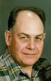
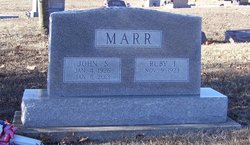
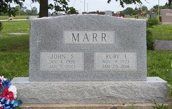
John Stanley Marr Sr.
| Birth | : | 4 Jan 1926 Luray, Russell County, Kansas, USA |
| Death | : | 5 Jan 2013 Topeka, Shawnee County, Kansas, USA |
| Burial | : | Holton Cemetery, Holton, Jackson County, USA |
| Coordinate | : | 39.4611015, -95.7583008 |
| Plot | : | Section J |
| Description | : | John Stanley Marr, Sr., 87, of Hoyt, KS passed away January 5, 2013 at Stormont Vail Hospital in Topeka. He was born January 4, 1926 in Luray, KS, the son of Edward Stanley and Nora Martha (Linder) Marr. John graduated from Natoma High School in Natoma, KS. John was drafted into the United States Army directly out of high school. He served during WWII in 33rd Mechanized Calvary; he was injured during the war and was honorably discharged with a Purple Heart and two Bronze Stars. After proudly serving his country, he moved to Hoyt and had lived there for... Read More |
frequently asked questions (FAQ):
-
Where is John Stanley Marr Sr.'s memorial?
John Stanley Marr Sr.'s memorial is located at: Holton Cemetery, Holton, Jackson County, USA.
-
When did John Stanley Marr Sr. death?
John Stanley Marr Sr. death on 5 Jan 2013 in Topeka, Shawnee County, Kansas, USA
-
Where are the coordinates of the John Stanley Marr Sr.'s memorial?
Latitude: 39.4611015
Longitude: -95.7583008
Family Members:
Flowers:
Nearby Cemetories:
1. Holton Cemetery
Holton, Jackson County, USA
Coordinate: 39.4611015, -95.7583008
2. Mount Calvary Catholic Cemetery
Holton, Jackson County, USA
Coordinate: 39.4700012, -95.7702026
3. Haas Cemetery
Circleville, Jackson County, USA
Coordinate: 39.4632988, -95.8107986
4. Carmel Cemetery
Circleville, Jackson County, USA
Coordinate: 39.4984400, -95.7967700
5. Weiss Family Cemetery
Holton, Jackson County, USA
Coordinate: 39.4562000, -95.8211000
6. Brick Cemetery
Jackson County, USA
Coordinate: 39.4206009, -95.7099991
7. Bradley Family Cemetery
Holton, Jackson County, USA
Coordinate: 39.4644928, -95.6813889
8. Wyant Family Cemetery
Holton, Jackson County, USA
Coordinate: 39.4778520, -95.6614440
9. Circleville Cemetery
Circleville, Jackson County, USA
Coordinate: 39.5014000, -95.8664017
10. Pleasant Grove Cemetery
Jackson County, USA
Coordinate: 39.5664000, -95.7789000
11. Mitchell Cemetery
Mayetta, Jackson County, USA
Coordinate: 39.3549995, -95.7996979
12. Masquat Cemetery
Mayetta, Jackson County, USA
Coordinate: 39.3821180, -95.8620510
13. Denison Cemetery
Denison, Jackson County, USA
Coordinate: 39.3973389, -95.6278000
14. Boan Cemetery
Soldier, Jackson County, USA
Coordinate: 39.4350014, -95.9227982
15. South Denison Cemetery
Denison, Jackson County, USA
Coordinate: 39.3833008, -95.6219025
16. Olive Hill Cemetery
Soldier, Jackson County, USA
Coordinate: 39.4631004, -95.9285965
17. Estes Cemetery
Jackson County, USA
Coordinate: 39.5346985, -95.6168976
18. Thompson-Burns Cemetery
Whiting, Jackson County, USA
Coordinate: 39.5062100, -95.5980710
19. Wells Family Cemetery
Jackson County, USA
Coordinate: 39.4677963, -95.5827866
20. James Cemetery
Jackson County, USA
Coordinate: 39.4535800, -95.9424500
21. Wishkeno Cemetery
Mayetta, Jackson County, USA
Coordinate: 39.3171700, -95.7756400
22. Ontario Cemetery
Nemaha County, USA
Coordinate: 39.5663795, -95.8885193
23. Larkinburg Cemetery
Jackson County, USA
Coordinate: 39.4794006, -95.5706024
24. Cedar Grove Cemetery
Mayetta, Jackson County, USA
Coordinate: 39.3368988, -95.6564026


