

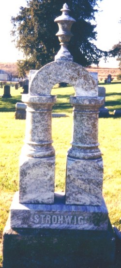
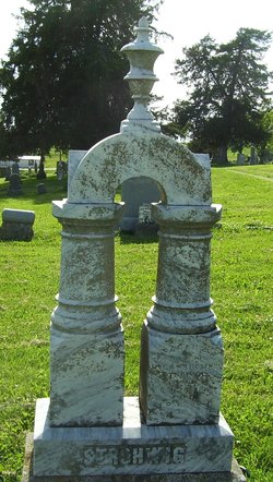
John Strohwig
| Birth | : | 25 May 1858 Jackson County, Kansas, USA |
| Death | : | 7 Jun 1881 Jackson County, Kansas, USA |
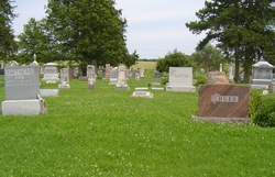
| Burial | : | Katanning Cemetery, Katanning, Katanning Shire, Australia |
| Coordinate | : | -33.6682290, 117.5462430 |
| Plot | : | Section 1 |
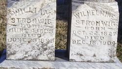
| Inscription | : | John, Son of Wm. & Wilhelmine Strohwig, Born May 25, 1858 - Died June 7, 1881 |
frequently asked questions (FAQ):
-
Where is John Strohwig's memorial?
John Strohwig's memorial is located at: Katanning Cemetery, Katanning, Katanning Shire, Australia.
-
When did John Strohwig death?
John Strohwig death on 7 Jun 1881 in Jackson County, Kansas, USA
-
Where are the coordinates of the John Strohwig's memorial?
Latitude: -33.6682290
Longitude: 117.5462430
Family Members:
Parent
Siblings
Flowers:


Nearby Cemetories:
1. Katanning Cemetery
Katanning, Katanning Shire, Australia
Coordinate: -33.6682290, 117.5462430
2. Eticup Cemetery
Broomehill, Broomehill-Tambellup Shire, Australia
Coordinate: -33.8328280, 117.5639560
3. Broomehill Cemetery
Broomehill, Broomehill-Tambellup Shire, Australia
Coordinate: -33.8477960, 117.6227830
4. Pindellup St. Peters Church of England
Tambellup, Broomehill-Tambellup Shire, Australia
Coordinate: -33.9755683, 117.4940883
5. Kojonup Cemetery
Kojonup, Kojonup Shire, Australia
Coordinate: -33.8248400, 117.1526770
6. Tambellup Cemetery
Tambellup, Broomehill-Tambellup Shire, Australia
Coordinate: -34.0353790, 117.6330330
7. Boscabel Cemetery
Boscabel, Kojonup Shire, Australia
Coordinate: -33.6658750, 117.0671800
8. Gnowangerup Cemetery
Gnowangerup, Gnowangerup Shire, Australia
Coordinate: -33.9461540, 118.0135490
9. Wansbrough Burial
Wansbrough, Broomehill-Tambellup Shire, Australia
Coordinate: -34.1425430, 117.6733960
10. Muradup Cemetery
Muradup, Kojonup Shire, Australia
Coordinate: -33.8454740, 116.9805800
11. Nyabing Cemetery
Nyabing, Kent Shire, Australia
Coordinate: -33.5333328, 118.1500015
12. Bonshaw Burial Ground
Cranbrook Shire, Australia
Coordinate: -34.1871390, 117.3203610
13. Tenterden War Memorial
Tenterden, Cranbrook Shire, Australia
Coordinate: -34.3652200, 117.5584600
14. Tenterden General Cemetery
Tenterden, Cranbrook Shire, Australia
Coordinate: -34.3652251, 117.5709322
15. Borden Cemetery
Borden, Gnowangerup Shire, Australia
Coordinate: -34.0727430, 118.2646100
16. Narrogin Cemetery
Narrogin, Narrogin Shire, Australia
Coordinate: -32.9397240, 117.1566650
17. Chowerup Cemetery
Chowerup, Boyup Brook Shire, Australia
Coordinate: -34.0858380, 116.7028610
18. Dudinin Cemetery
Kulin, Kulin Shire, Australia
Coordinate: -32.8802640, 117.9205480
19. Dinninup Cemetery
Boyup Brook Shire, Australia
Coordinate: -33.7845110, 116.5315440
20. Cuballing Cemetery
Cuballing, Cuballing Shire, Australia
Coordinate: -32.8324970, 117.1697320
21. Boyup Brook Public Cemetery
Boyup Brook, Boyup Brook Shire, Australia
Coordinate: -33.8193550, 116.3932030
22. Mount Barker Cemetery West
Mount Barker, Plantagenet Shire, Australia
Coordinate: -34.6437679, 117.6692459
23. Mount Barker Cemetery East
Mount Barker, Plantagenet Shire, Australia
Coordinate: -34.6437373, 117.6709039
24. St. Werburgh's Chapel & Cemetery
Mount Barker, Plantagenet Shire, Australia
Coordinate: -34.6853069, 117.5996387