
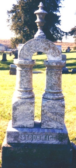
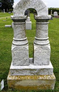
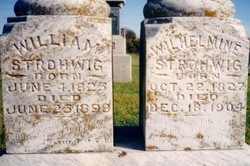

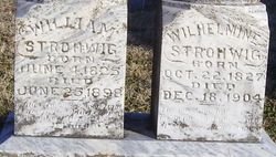
William Strohwig
| Birth | : | 4 Jun 1825 Germany |
| Death | : | 25 Jun 1898 Holton, Jackson County, Kansas, USA |
| Burial | : | Katanning Cemetery, Katanning, Katanning Shire, Australia |
| Coordinate | : | -33.6682290, 117.5462430 |
| Plot | : | Section 1 |
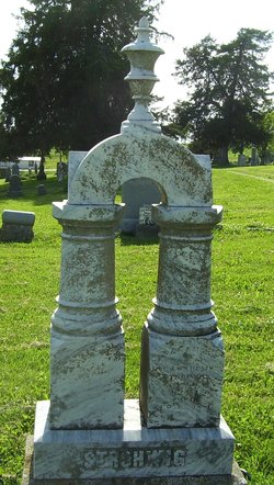
| Inscription | : | William Strohwig, Born June 4, 1825 - Died June 25, 1898 |
| Description | : | STROHWIG Wm. Strohwig was born in Prussia, June 4, 1825, and died Saturday morning June 25, 1898, aged 73 years and 21 days. Mr. Strohwig was married to Miss Wilhelmina Michelis, January 24, 1850, and two years later, with his wife, bid good bye to their fatherland and cast their lot in this country. They lived in Wisconsin five years, and forty years ago came to this county along with the first settlers. He entered a farm five miles northwest of this city, which he improved, and on which he lived and labored a quarter of a century.... Read More |
frequently asked questions (FAQ):
-
Where is William Strohwig's memorial?
William Strohwig's memorial is located at: Katanning Cemetery, Katanning, Katanning Shire, Australia.
-
When did William Strohwig death?
William Strohwig death on 25 Jun 1898 in Holton, Jackson County, Kansas, USA
-
Where are the coordinates of the William Strohwig's memorial?
Latitude: -33.6682290
Longitude: 117.5462430
Family Members:
Parent
Spouse
Children

Flowers:


Nearby Cemetories:
1. Katanning Cemetery
Katanning, Katanning Shire, Australia
Coordinate: -33.6682290, 117.5462430
2. Eticup Cemetery
Broomehill, Broomehill-Tambellup Shire, Australia
Coordinate: -33.8328280, 117.5639560
3. Broomehill Cemetery
Broomehill, Broomehill-Tambellup Shire, Australia
Coordinate: -33.8477960, 117.6227830
4. Pindellup St. Peters Church of England
Tambellup, Broomehill-Tambellup Shire, Australia
Coordinate: -33.9755683, 117.4940883
5. Kojonup Cemetery
Kojonup, Kojonup Shire, Australia
Coordinate: -33.8248400, 117.1526770
6. Tambellup Cemetery
Tambellup, Broomehill-Tambellup Shire, Australia
Coordinate: -34.0353790, 117.6330330
7. Boscabel Cemetery
Boscabel, Kojonup Shire, Australia
Coordinate: -33.6658750, 117.0671800
8. Gnowangerup Cemetery
Gnowangerup, Gnowangerup Shire, Australia
Coordinate: -33.9461540, 118.0135490
9. Wansbrough Burial
Wansbrough, Broomehill-Tambellup Shire, Australia
Coordinate: -34.1425430, 117.6733960
10. Muradup Cemetery
Muradup, Kojonup Shire, Australia
Coordinate: -33.8454740, 116.9805800
11. Nyabing Cemetery
Nyabing, Kent Shire, Australia
Coordinate: -33.5333328, 118.1500015
12. Bonshaw Burial Ground
Cranbrook Shire, Australia
Coordinate: -34.1871390, 117.3203610
13. Tenterden War Memorial
Tenterden, Cranbrook Shire, Australia
Coordinate: -34.3652200, 117.5584600
14. Tenterden General Cemetery
Tenterden, Cranbrook Shire, Australia
Coordinate: -34.3652251, 117.5709322
15. Borden Cemetery
Borden, Gnowangerup Shire, Australia
Coordinate: -34.0727430, 118.2646100
16. Narrogin Cemetery
Narrogin, Narrogin Shire, Australia
Coordinate: -32.9397240, 117.1566650
17. Chowerup Cemetery
Chowerup, Boyup Brook Shire, Australia
Coordinate: -34.0858380, 116.7028610
18. Dudinin Cemetery
Kulin, Kulin Shire, Australia
Coordinate: -32.8802640, 117.9205480
19. Dinninup Cemetery
Boyup Brook Shire, Australia
Coordinate: -33.7845110, 116.5315440
20. Cuballing Cemetery
Cuballing, Cuballing Shire, Australia
Coordinate: -32.8324970, 117.1697320
21. Boyup Brook Public Cemetery
Boyup Brook, Boyup Brook Shire, Australia
Coordinate: -33.8193550, 116.3932030
22. Mount Barker Cemetery West
Mount Barker, Plantagenet Shire, Australia
Coordinate: -34.6437679, 117.6692459
23. Mount Barker Cemetery East
Mount Barker, Plantagenet Shire, Australia
Coordinate: -34.6437373, 117.6709039
24. St. Werburgh's Chapel & Cemetery
Mount Barker, Plantagenet Shire, Australia
Coordinate: -34.6853069, 117.5996387