

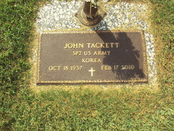
John Tackett
| Birth | : | 18 Oct 1937 Anderson County, Tennessee, USA |
| Death | : | 17 Feb 2010 Oak Ridge, Anderson County, Tennessee, USA |
| Burial | : | Huntingford Christ Church Anglican Cemetery, Huntingford, Oxford County Municipality, Canada |
| Coordinate | : | 43.2000280, -80.7960970 |
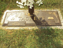
| Description | : | John Tackett, age 72, of Lake City, passed away Wednesday, February 17, 2010 at the Methodist Medical Center. He was born October 18, 1937 in Anderson County, Tn. to the late Bill and Magdalene Wilson Tackett. He was a US Army Veteran. He was a member of Mountain View Baptist Church. He loved the mountains, enjoyed woodworking, ginseng hunting, and spending time with his family and friends. In addition to his parents, he is preceded in death by son, Steve Tackett, and sister, Ruth Massengill. Survivors Daughter Teresa Killingsworth & husband, Tom Boise,Idaho Mother of his children Carol Tackett Boise, Idaho... Read More |
frequently asked questions (FAQ):
-
Where is John Tackett's memorial?
John Tackett's memorial is located at: Huntingford Christ Church Anglican Cemetery, Huntingford, Oxford County Municipality, Canada.
-
When did John Tackett death?
John Tackett death on 17 Feb 2010 in Oak Ridge, Anderson County, Tennessee, USA
-
Where are the coordinates of the John Tackett's memorial?
Latitude: 43.2000280
Longitude: -80.7960970
Family Members:
Parent

Siblings

Flowers:


Nearby Cemetories:
1. Huntingford Christ Church Anglican Cemetery
Huntingford, Oxford County Municipality, Canada
Coordinate: 43.2000280, -80.7960970
2. Vandecar Cemetery
Vandecar, Oxford County Municipality, Canada
Coordinate: 43.2010640, -80.8148020
3. House of Refuge Cemetery
Woodstock, Oxford County Municipality, Canada
Coordinate: 43.1476245, -80.7873872
4. Anglican Cemetery
Woodstock, Oxford County Municipality, Canada
Coordinate: 43.1426000, -80.7653300
5. Woodstock Baptist Cemetery
Woodstock, Oxford County Municipality, Canada
Coordinate: 43.1416460, -80.7655790
6. Woodstock Presbyterian Cemetery
Woodstock, Oxford County Municipality, Canada
Coordinate: 43.1409440, -80.7651600
7. Old Log Church Cemetery
Embro, Oxford County Municipality, Canada
Coordinate: 43.1529121, -80.8626785
8. Innerkip Cemetery
Innerkip, Oxford County Municipality, Canada
Coordinate: 43.2050000, -80.6929000
9. Old St. Paul's Anglican Cemetery
Woodstock, Oxford County Municipality, Canada
Coordinate: 43.1325600, -80.7462300
10. Trinity Anglican Cemetery
East Zorra-Tavistock, Oxford County Municipality, Canada
Coordinate: 43.2731930, -80.8327340
11. Hillview Cemetery
Woodstock, Oxford County Municipality, Canada
Coordinate: 43.1206703, -80.7675400
12. North Embro Cemetery
Embro, Oxford County Municipality, Canada
Coordinate: 43.1667920, -80.9040350
13. Oxford Memorial Park Cemetery
Woodstock, Oxford County Municipality, Canada
Coordinate: 43.1148200, -80.8150400
14. Methodist Cemetery
Embro, Oxford County Municipality, Canada
Coordinate: 43.1495018, -80.8983841
15. Saint Marys Roman Catholic Cemetery
Woodstock, Oxford County Municipality, Canada
Coordinate: 43.1089400, -80.7998900
16. Ratho Presbyterian Cemetery
Ratho, Oxford County Municipality, Canada
Coordinate: 43.2772464, -80.7046934
17. Saint Matthews Lutheran Church Cemetery
Cassel, Oxford County Municipality, Canada
Coordinate: 43.3079100, -80.7763100
18. Blandford Cemetery
Bright, Oxford County Municipality, Canada
Coordinate: 43.2573500, -80.6638000
19. East Zorra Municipal Cemetery Brickyard
East Zorra-Tavistock, Oxford County Municipality, Canada
Coordinate: 43.3125934, -80.8002093
20. Beachville Cemetery
Beachville, Oxford County Municipality, Canada
Coordinate: 43.0889511, -80.8313599
21. Saint Johns Anglican Cemetery
Eastwood, Oxford County Municipality, Canada
Coordinate: 43.1443080, -80.6575850
22. Evangelical United Brethren Cemetery
East Zorra-Tavistock, Oxford County Municipality, Canada
Coordinate: 43.3127430, -80.7619650
23. Grace United Cemetery
Tavistock, Oxford County Municipality, Canada
Coordinate: 43.3182869, -80.8390884
24. East Zorra Mennonite Cemetery
East Zorra-Tavistock, Oxford County Municipality, Canada
Coordinate: 43.3225700, -80.7862700