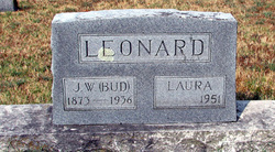
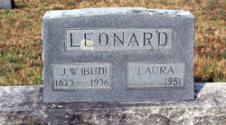
John William “Bud” Leonard
| Birth | : | 13 Feb 1873 Benton County, Arkansas, USA |
| Death | : | 17 Feb 1936 South West City, McDonald County, Missouri, USA |
| Burial | : | Logan Township Cemetery, Clay County, USA |
| Coordinate | : | 43.0489006, -94.9747009 |
| Description | : | Bud was the son of Cicero George Washington Leonard & Martha E. Bagby. He married Laura A. Oyler on 15 October 1913 in Kansas City, MO and they had no children. Bud went to live with an uncle in Southwest City, MO after his mother died in 1889. He soon became owner of a livery stable, a saw mill and the Southwest City Distillery. The Woman's Christian Temperance Union shut down all distilleries in Missouri, so Bud sold his other businesses and went to Hermosillo, Sonora, Mexico to become the Manager of a 40,000 acre cattle and horse ranch. He... Read More |
frequently asked questions (FAQ):
-
Where is John William “Bud” Leonard's memorial?
John William “Bud” Leonard's memorial is located at: Logan Township Cemetery, Clay County, USA.
-
When did John William “Bud” Leonard death?
John William “Bud” Leonard death on 17 Feb 1936 in South West City, McDonald County, Missouri, USA
-
Where are the coordinates of the John William “Bud” Leonard's memorial?
Latitude: 43.0489006
Longitude: -94.9747009
Family Members:
Flowers:
Nearby Cemetories:
1. Logan Township Cemetery
Clay County, USA
Coordinate: 43.0489006, -94.9747009
2. Calvary Cemetery
Silver Lake Township, Palo Alto County, USA
Coordinate: 43.0386009, -94.8613968
3. Dickens Cemetery
Dickens, Clay County, USA
Coordinate: 43.1280000, -95.0155000
4. Silver Lake Cemetery
Silver Lake Township, Palo Alto County, USA
Coordinate: 43.0386009, -94.8597031
5. Rosehill Cemetery
Clay County, USA
Coordinate: 43.0368996, -95.0919037
6. Garfield Township Cemetery
Webb, Clay County, USA
Coordinate: 42.9538994, -94.9392014
7. Calvary Cemetery
Ruthven, Palo Alto County, USA
Coordinate: 43.1314011, -94.8869019
8. Crown Hill Cemetery
Ruthven, Palo Alto County, USA
Coordinate: 43.1328011, -94.8878021
9. Osborn Cemetery
Webb, Clay County, USA
Coordinate: 42.9346918, -95.0608244
10. Highland Cemetery
Highland Township, Palo Alto County, USA
Coordinate: 43.1497002, -94.8578033
11. Liberty Cemetery
Greenville, Clay County, USA
Coordinate: 42.9897003, -95.1417007
12. Burr Oak Cemetery
Herdland Township, Clay County, USA
Coordinate: 42.9235992, -95.0907974
13. Dewey Readmore Books Memorial
Spencer, Clay County, USA
Coordinate: 43.1403999, -95.1443024
14. Fairview Cemetery
Clay County, USA
Coordinate: 43.1899986, -95.0800018
15. Fanny Fern Cemetery
Clay County, USA
Coordinate: 42.9530983, -95.1607971
16. North Lawn Cemetery
Spencer, Clay County, USA
Coordinate: 43.1600000, -95.1470000
17. Riverside Cemetery
Spencer, Clay County, USA
Coordinate: 43.1441994, -95.1671982
18. Lost Island Lutheran Cemetery
Lost Island Township, Palo Alto County, USA
Coordinate: 43.1980000, -94.8375000
19. Poland Township Cemetery
Marathon, Buena Vista County, USA
Coordinate: 42.8610992, -94.9916992
20. Swedish Lutheran Cemetery
Royal, Clay County, USA
Coordinate: 43.0683000, -95.2350000
21. Lincoln Cemetery
Rossie, Clay County, USA
Coordinate: 43.0111008, -95.2313995
22. Saint Paul Lutheran Cemetery
Walnut Township, Palo Alto County, USA
Coordinate: 43.1866740, -94.7872050
23. Saint Josephs Cemetery
Sioux Rapids, Buena Vista County, USA
Coordinate: 42.8883018, -95.1324997
24. Rush Lake Cemetery
Rush Lake Township, Palo Alto County, USA
Coordinate: 42.9497185, -94.7383270


