
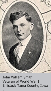
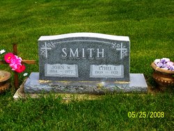
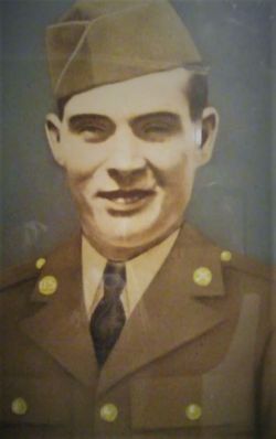
John William “Cap or Captain John” Smith
| Birth | : | 6 Dec 1884 East Lynn, Vermilion County, Illinois, USA |
| Death | : | 7 Sep 1977 Toledo, Tama County, Iowa, USA |
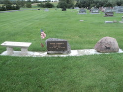
| Burial | : | Maple Hill Cemetery, Montour, Tama County, USA |
| Coordinate | : | 41.9756012, -92.7069016 |
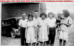
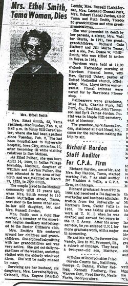
| Description | : | John William Smith is my grand father. He and his wife raised their 7 children in a box car in Montour, Tama county, Iowa. The area of Montour in which they lived was once known as Whiskey Bottom. Their only son was killed in in Korea during the Korean war. (1951) John W. Smith was known to many as Captain John or Cap. He resided in Ziegler's nursing home in Tama, Iowa for many years and then was moved to Sunny Hill care center in Tama, Iowa where he passed away. |
frequently asked questions (FAQ):
-
Where is John William “Cap or Captain John” Smith's memorial?
John William “Cap or Captain John” Smith's memorial is located at: Maple Hill Cemetery, Montour, Tama County, USA.
-
When did John William “Cap or Captain John” Smith death?
John William “Cap or Captain John” Smith death on 7 Sep 1977 in Toledo, Tama County, Iowa, USA
-
Where are the coordinates of the John William “Cap or Captain John” Smith's memorial?
Latitude: 41.9756012
Longitude: -92.7069016
Family Members:
Parent

Spouse
Siblings
Children
Flowers:


Nearby Cemetories:
1. Maple Hill Cemetery
Montour, Tama County, USA
Coordinate: 41.9756012, -92.7069016
2. Rouse Cemetery
Montour, Tama County, USA
Coordinate: 41.9967003, -92.6875000
3. Butlerville Cemetery
Tama, Tama County, USA
Coordinate: 41.9973000, -92.7300000
4. McIntosh Cemetery
Tama, Tama County, USA
Coordinate: 41.9868890, -92.6453060
5. West Cemetery
Tama County, USA
Coordinate: 41.9749985, -92.6306000
6. Stavanger Friends Cemetery
Le Grand, Marshall County, USA
Coordinate: 41.9673500, -92.7858000
7. Meskwaki Cemetery
Tama, Tama County, USA
Coordinate: 41.9730988, -92.6256027
8. Strand Lutheran Cemetery
Dunbar, Marshall County, USA
Coordinate: 41.9420433, -92.7793467
9. Friends Cemetery
Le Grand, Marshall County, USA
Coordinate: 42.0062000, -92.7856000
10. Turner Cemetery
Garwin, Tama County, USA
Coordinate: 42.0355988, -92.6691971
11. Pleasant Hill Cemetery
Le Grand, Marshall County, USA
Coordinate: 42.0210991, -92.7758026
12. Croskrey Cemetery
Tama, Tama County, USA
Coordinate: 41.9401000, -92.6242500
13. Mattingly Cemetery
Garwin, Tama County, USA
Coordinate: 42.0527000, -92.6984000
14. Dobson Cemetery
Garwin, Tama County, USA
Coordinate: 42.0527344, -92.7479553
15. Dodson Cemetery
Tama County, USA
Coordinate: 42.0527992, -92.7478027
16. Korns Cemetery
Tama County, USA
Coordinate: 41.8918991, -92.6941986
17. Trinity Lutheran Cemetery
Dillon, Marshall County, USA
Coordinate: 41.9650002, -92.8227997
18. Saint Patricks Cemetery
Tama, Tama County, USA
Coordinate: 41.9789009, -92.5757980
19. Woodlawn Cemetery
Toledo, Tama County, USA
Coordinate: 41.9866982, -92.5699997
20. Maple Grove Cemetery
Tama, Tama County, USA
Coordinate: 41.8913994, -92.6268997
21. Bowles Cemetery
Green Mountain, Marshall County, USA
Coordinate: 42.0493147, -92.8053903
22. Rock Creek Cemetery
Tama County, USA
Coordinate: 42.0793991, -92.7283020
23. Rock Valley Cemetery
Le Grand, Marshall County, USA
Coordinate: 42.0078011, -92.8452988
24. Prairie View Cemetery
Gilman, Marshall County, USA
Coordinate: 41.8871710, -92.7961460