
| Birth | : | 1913 |
| Death | : | 10 Feb 1914 |
| Burial | : | Emmanuel Churchyard, Holcombe, Metropolitan Borough of Bury, England |
| Coordinate | : | 53.6463000, -2.3293400 |
| Plot | : | 3 4-3 |
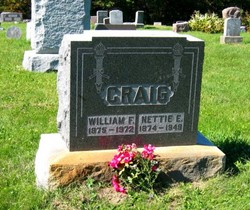
| Description | : | Decatur County Journal Leon, Iowa Thursday, February 19, 1914 JOHN WILLIAM, youngest child of W.F. and NETTIE E. CRAIG, was born Feb. 14, 1913. He fell asleep Feb. 10, 1914, at 11:05 p.m., after an illness of nine days from lung fever. All that loving hands could do was done, but the Divine Father saw the need of one more bud of promise to the tree of life. Therefore little JOHN was called. Closer and closer did the petals fold until the little heart, and mind slept. The happy smile that always brightened up his angelic little countenance will be... Read More |
frequently asked questions (FAQ):
-
Where is John William Craig's memorial?
John William Craig's memorial is located at: Emmanuel Churchyard, Holcombe, Metropolitan Borough of Bury, England.
-
When did John William Craig death?
John William Craig death on 10 Feb 1914 in
-
Where are the coordinates of the John William Craig's memorial?
Latitude: 53.6463000
Longitude: -2.3293400
Family Members:
Parent

Siblings
Flowers:


Nearby Cemetories:
1. Emmanuel Churchyard
Holcombe, Metropolitan Borough of Bury, England
Coordinate: 53.6463000, -2.3293400
2. Ramsbottom Cemetery
Ramsbottom, Metropolitan Borough of Bury, England
Coordinate: 53.6372986, -2.3271000
3. St. John-in-the-Wilderness Churchyard
Shuttleworth, Metropolitan Borough of Bury, England
Coordinate: 53.6556300, -2.3046500
4. St. John in the Wilderness Shuttleworrth
Walmersley, Metropolitan Borough of Bury, England
Coordinate: 53.6557090, -2.3037740
5. Stubbins Congregational Chapelyard
Rossendale Borough, England
Coordinate: 53.6626600, -2.3110700
6. Rowlands Methodist Churchyard
Summerseat, Metropolitan Borough of Bury, England
Coordinate: 53.6294360, -2.3102920
7. Greenmount United Reformed Churchyard
Greenmount, Metropolitan Borough of Bury, England
Coordinate: 53.6254581, -2.3381465
8. St Mary Churchyard
Hawkshaw, Metropolitan Borough of Bury, England
Coordinate: 53.6307270, -2.3636210
9. Hawkshaw Methodist Church Cemetery
Hawkshaw, Metropolitan Borough of Bury, England
Coordinate: 53.6313490, -2.3674190
10. St Anne Churchyard
Tottington, Metropolitan Borough of Bury, England
Coordinate: 53.6161499, -2.3409030
11. Edenfield Parish Churchyard
Ramsbottom, Metropolitan Borough of Bury, England
Coordinate: 53.6742799, -2.3069304
12. Park Chapel
Walmersley, Metropolitan Borough of Bury, England
Coordinate: 53.6205060, -2.2958590
13. St. John's Churchyard
Tottington, Metropolitan Borough of Bury, England
Coordinate: 53.6141180, -2.3400670
14. Christ Church Churchyard
Walmersley, Metropolitan Borough of Bury, England
Coordinate: 53.6193360, -2.2964630
15. Christ Church Churchyard
Bury, Metropolitan Borough of Bury, England
Coordinate: 53.6194570, -2.2960140
16. Congregational Churchyard
Affetside, Metropolitan Borough of Bury, England
Coordinate: 53.6175200, -2.3705800
17. Methodist Church Churchyard
Edgworth, Blackburn with Darwen Unitary Authority, England
Coordinate: 53.6424280, -2.3962830
18. Edgworth Congregational Chapelyard
Edgworth, Blackburn with Darwen Unitary Authority, England
Coordinate: 53.6476280, -2.3967210
19. Saint Thomas Churchyard
Helmshore, Rossendale Borough, England
Coordinate: 53.6870400, -2.3300000
20. St. Anne's Churchyard
Chapeltown, Blackburn with Darwen Unitary Authority, England
Coordinate: 53.6371710, -2.4030440
21. St. James Churchyard
Bury, Metropolitan Borough of Bury, England
Coordinate: 53.5996770, -2.3214600
22. All Saints Churchyard
Elton, Metropolitan Borough of Bury, England
Coordinate: 53.5965000, -2.3118000
23. Tottington Road Methodist Church Churchyard
Harwood, Metropolitan Borough of Bolton, England
Coordinate: 53.6079190, -2.3904960
24. Haslingden Cemetery
Haslingden, Rossendale Borough, England
Coordinate: 53.6989500, -2.3427700