

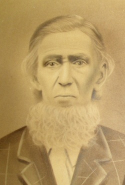

Johnathan Wesley Shelley
| Birth | : | 13 Dec 1839 Kentucky, USA |
| Death | : | 12 May 1920 Bartlett, Shannon County, Missouri, USA |
| Burial | : | Cementerio Municipal Viejo, Yauco, Yauco Municipality, USA |
| Coordinate | : | 18.0356000, -66.8561600 |
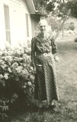
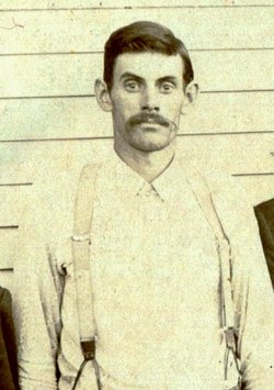
| Description | : | John was the son of Thomas S. and Amanda M. Smith Shelley. He was born in Clinton County, Kentucky. He married Mary Jane Bybee on September 18, 1859 in the same county. Shortly after the birth of their first child John left to serve in the Civil War, returning about 1865. During the following years seven more children were born, but after the birth of the last child John and Mary decided to move to Missouri. Settling in the Birch Tree area in Shannon County. Here, they lived the remainder of their lives, surrounded by most of their... Read More |
frequently asked questions (FAQ):
-
Where is Johnathan Wesley Shelley's memorial?
Johnathan Wesley Shelley's memorial is located at: Cementerio Municipal Viejo, Yauco, Yauco Municipality, USA.
-
When did Johnathan Wesley Shelley death?
Johnathan Wesley Shelley death on 12 May 1920 in Bartlett, Shannon County, Missouri, USA
-
Where are the coordinates of the Johnathan Wesley Shelley's memorial?
Latitude: 18.0356000
Longitude: -66.8561600
Family Members:
Spouse
Children


Nearby Cemetories:
1. Cementerio Municipal Viejo
Yauco, Yauco Municipality, USA
Coordinate: 18.0356000, -66.8561600
2. Cementerio Municipal Nuevo
Yauco, Yauco Municipality, USA
Coordinate: 18.0353500, -66.8568700
3. Santa Basilica Metropolitana Iglesia Catedral
Santiago de Cuba, Municipio de Santiago de Cuba, Cuba
Coordinate: 18.0384400, -66.8712700
4. Cementerio Nuevo Los Pinos
Guayanilla, Guayanilla Municipality, USA
Coordinate: 18.0172020, -66.7952230
5. Cementerio Municipal de Guayanilla
Guayanilla, Guayanilla Municipality, USA
Coordinate: 18.0247726, -66.7870865
6. Cementerio Municipal de Guanica
Guanica, Guanica Municipality, USA
Coordinate: 17.9800910, -66.9204540
7. Getsemaní Memorial Park
Susua, Sabana Grande Municipality, USA
Coordinate: 18.0825900, -66.9439900
8. Cementerio Masónico Sabana Grande
Sabana Grande, Sabana Grande Municipality, USA
Coordinate: 18.0801400, -66.9678500
9. Cementerio Municipal
Sabana Grande, Sabana Grande Municipality, USA
Coordinate: 18.0802212, -66.9678879
10. Cementerio Penuelas
Penuelas, Penuelas Municipality, USA
Coordinate: 18.0557080, -66.7260120
11. Cementerio Municipal Yahuecas
Adjuntas, Adjuntas Municipality, USA
Coordinate: 18.1885900, -66.7773100
12. Cementerio Río Prieto
Castaner, Lares Municipality, USA
Coordinate: 18.2085125, -66.8974098
13. Cementerio Luz del Gigante
Adjuntas, Adjuntas Municipality, USA
Coordinate: 18.1658260, -66.7290920
14. Cementerio Porta Coeli
San German, San German Municipality, USA
Coordinate: 18.0904730, -67.0385420
15. Camposanto de Cristo Resucitado
Ponce, Ponce Municipality, USA
Coordinate: 17.9791720, -66.6655760
16. Cementerio Municipal
Maricao, Maricao Municipality, USA
Coordinate: 18.1855520, -66.9833010
17. Antiguo Cementerio Municipal
San German, San German Municipality, USA
Coordinate: 18.0825750, -67.0527120
18. Cementerio Trujillo
San German, San German Municipality, USA
Coordinate: 18.0816680, -67.0532020
19. Cementerio Municipal De Lajas
Lajas, Lajas Municipality, USA
Coordinate: 18.0448700, -67.0610500
20. Cementerio La Piedad
Ponce, Ponce Municipality, USA
Coordinate: 18.0409320, -66.6462850
21. Cementerio Católico San Vicente de Paul
Ponce, Ponce Municipality, USA
Coordinate: 18.0170790, -66.6337570
22. Cementerio Civil de Ponce
Ponce, Ponce Municipality, USA
Coordinate: 18.0146870, -66.6326730
23. Cementerio El Yeso
Ponce, Ponce Municipality, USA
Coordinate: 18.0351250, -66.6243110
24. Cementerio Municipal de la Playa
Ponce, Ponce Municipality, USA
Coordinate: 17.9848850, -66.6288700