
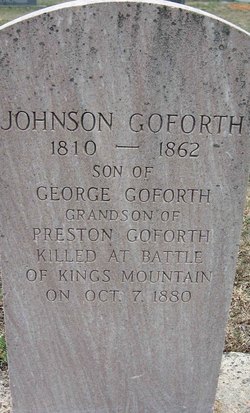
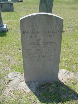
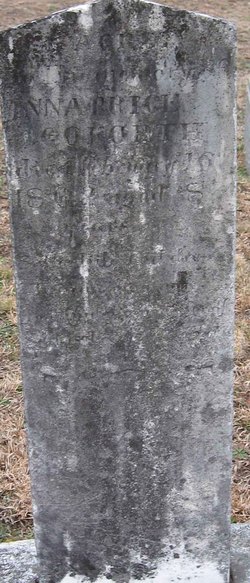
Johnson Goforth
| Birth | : | 17 Oct 1810 North Carolina, USA |
| Death | : | 14 Mar 1862 York County, South Carolina, USA |
| Burial | : | Andersons Creek Cemetery, Warrandyte, Manningham City, Australia |
| Coordinate | : | -37.7463170, 145.2130940 |
| Inscription | : | Son of George Goforth Grandson Of Preston Goforth killed at Battle of Kings Mountain on OCT 7 1880 |
| Description | : | Suggested edit: Unfortunate error on the headstone inscription itself at the bottom: the Battle of King’s Mtn. was in 1780, not 1880. His grandfather, Preston Goforth actually died on Oct. 7 1780. Although the extra info. is very nice, that mistake did make it confusing. Maybe something could be attached to this page that points this out so that others wont be confused too? Thanks for considering. Contributor: M. Haire (50488043) |
frequently asked questions (FAQ):
-
Where is Johnson Goforth's memorial?
Johnson Goforth's memorial is located at: Andersons Creek Cemetery, Warrandyte, Manningham City, Australia.
-
When did Johnson Goforth death?
Johnson Goforth death on 14 Mar 1862 in York County, South Carolina, USA
-
Where are the coordinates of the Johnson Goforth's memorial?
Latitude: -37.7463170
Longitude: 145.2130940
Family Members:
Parent
Spouse
Siblings
Children


Nearby Cemetories:
1. Andersons Creek Cemetery
Warrandyte, Manningham City, Australia
Coordinate: -37.7463170, 145.2130940
2. Eltham Cemetery
Eltham, Nillumbik Shire, Australia
Coordinate: -37.7266370, 145.1504720
3. Templestowe Cemetery and Memorial Gardens
Templestowe, Manningham City, Australia
Coordinate: -37.7594730, 145.1418370
4. Waldau Cemetery
Doncaster East, Manningham City, Australia
Coordinate: -37.7776130, 145.1455570
5. St. Paul's Anglican Memorial Lawn
Ringwood, Maroondah City, Australia
Coordinate: -37.8103347, 145.2311387
6. Kangaroo Ground Cemetery
Kangaroo Ground, Nillumbik Shire, Australia
Coordinate: -37.6818430, 145.2368440
7. Our Lady of Perpetual Help Catholic Memorial Wall
Ringwood, Maroondah City, Australia
Coordinate: -37.8158091, 145.2322232
8. St Katherine's Cemetery
Saint Helena, Banyule City, Australia
Coordinate: -37.6924510, 145.1288510
9. Diamond Creek Cemetery
Diamond Creek, Nillumbik Shire, Australia
Coordinate: -37.6758770, 145.1465020
10. Plenty River Pioneer Children's Cemetery
Greensborough, Banyule City, Australia
Coordinate: -37.6876217, 145.1168695
11. Hurstbridge Cemetery
Hurstbridge, Nillumbik Shire, Australia
Coordinate: -37.6500015, 145.2166595
12. Lilydale Lawn Cemetery
Lilydale, Yarra Ranges Shire, Australia
Coordinate: -37.7464730, 145.3382850
13. Box Hill Cemetery
Box Hill, Whitehorse City, Australia
Coordinate: -37.8236980, 145.1346290
14. Greensborough Cemetery
Greensborough, Banyule City, Australia
Coordinate: -37.7004060, 145.1006880
15. St Paschal Friary Cemetery
Box Hill, Whitehorse City, Australia
Coordinate: -37.8255280, 145.1327820
16. Lilydale Memorial Park
Lilydale, Yarra Ranges Shire, Australia
Coordinate: -37.7361400, 145.3427400
17. Heidelberg Old Cemetery
Heidelberg, Banyule City, Australia
Coordinate: -37.7479500, 145.0656200
18. Warringal Cemetery
Heidelberg, Banyule City, Australia
Coordinate: -37.7524048, 145.0586967
19. Queenstown Cemetery
Smiths Gully, Nillumbik Shire, Australia
Coordinate: -37.6203400, 145.2730600
20. Burwood Cemetery
Burwood, Whitehorse City, Australia
Coordinate: -37.8524906, 145.1005747
21. Preston General Cemetery
Bundoora, Banyule City, Australia
Coordinate: -37.7201480, 145.0405825
22. Boroondara General Cemetery
Kew, Boroondara City, Australia
Coordinate: -37.8036300, 145.0396300
23. Ferntree Gully Cemetery
Ferntree Gully, Knox City, Australia
Coordinate: -37.8822620, 145.2979050
24. Yarra Glen Cemetery
Yarra Glen, Yarra Ranges Shire, Australia
Coordinate: -37.6471130, 145.3662500