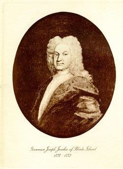
Joseph Jencks Jr.
| Birth | : | 12 Oct 1628 Buckinghamshire, England |
| Death | : | 4 Jan 1717 Pawtucket, Providence County, Rhode Island, USA |
| Burial | : | West Granby Cemetery, Granby, Hartford County, USA |
| Coordinate | : | 41.9535522, -72.8400421 |
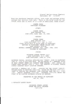
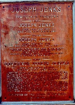
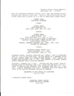
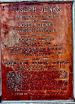
| Inscription | : | Joseph Jenks. Born England 1632. Died Pawtucket, R I. Jan 4, 1417. First White Male to Build Home in Pawtucket. Settled in Pawtucket, Rhode Island 1655. Town Council 1679-80. General Assembly Speaker Oct 1698-Feb 1699. Founde |
| Description | : | **Originally interred in the Governor Joseph Jenks lot, and exhumed June 2 1831 and removed to Mineral Spring in unknown location. This is documented in a statement dated November 19, 1997 from the Mineral Spring Cemetery. He was baptized in Colnbrook, Horton, Co.Buckinghamshire on Oct 12,1628, the son of Joseph Jenckes (also spelled Jenks, Jencks, Jenkes) and his first wife Joan Hearne Jenckes. Joseph Jenckes II is known as the founder of Pawtucket. A skilled ironworker, he had come to the New World to join his father, Joseph Jencks I, who had organized and operated the first... Read More |
frequently asked questions (FAQ):
-
Where is Joseph Jencks Jr.'s memorial?
Joseph Jencks Jr.'s memorial is located at: West Granby Cemetery, Granby, Hartford County, USA.
-
When did Joseph Jencks Jr. death?
Joseph Jencks Jr. death on 4 Jan 1717 in Pawtucket, Providence County, Rhode Island, USA
-
Where are the coordinates of the Joseph Jencks Jr.'s memorial?
Latitude: 41.9535522
Longitude: -72.8400421
Family Members:
Parent
Spouse
Siblings
Children
Flowers:
Nearby Cemetories:
1. West Granby Cemetery
Granby, Hartford County, USA
Coordinate: 41.9535522, -72.8400421
2. Pratt Cemetery
Granby, Hartford County, USA
Coordinate: 41.9710999, -72.8143997
3. Baptist Cemetery
Granby, Hartford County, USA
Coordinate: 41.9841995, -72.8202972
4. Granby Cemetery
Granby, Hartford County, USA
Coordinate: 41.9571991, -72.7913971
5. The First Church Memorial Garden
Granby, Hartford County, USA
Coordinate: 41.9538918, -72.7891693
6. Wright Cemetery
Hartland, Hartford County, USA
Coordinate: 41.9744873, -72.8938980
7. Cooley Cemetery
North Granby, Hartford County, USA
Coordinate: 41.9967003, -72.8127975
8. Holcomb Cemetery
East Granby, Hartford County, USA
Coordinate: 41.9371223, -72.7716751
9. Hartford Mutual Society Memorial Park
East Granby, Hartford County, USA
Coordinate: 41.9196815, -72.7742538
10. Congregation Teferes Israel Memorial Park
East Granby, Hartford County, USA
Coordinate: 41.9217300, -72.7715912
11. Beth Hillel Synagogue Memorial Park
East Granby, Hartford County, USA
Coordinate: 41.9218216, -72.7706451
12. Spring Cemetery
Granby, Hartford County, USA
Coordinate: 41.9983177, -72.7850494
13. Merriam Cemetery
North Granby, Hartford County, USA
Coordinate: 42.0181000, -72.8401400
14. East Hartland Cemetery
Hartland, Hartford County, USA
Coordinate: 41.9993210, -72.9045792
15. North Canton United Methodist Memorial Garden
Canton, Hartford County, USA
Coordinate: 41.8991030, -72.8913320
16. Poor Farm Cemetery
Granby, Hartford County, USA
Coordinate: 42.0203180, -72.8416990
17. Copper Hill Cemetery
East Granby, Hartford County, USA
Coordinate: 41.9766998, -72.7530975
18. Tariffville Cemetery
Tariffville, Hartford County, USA
Coordinate: 41.9079132, -72.7694473
19. Saint Bernard Cemetery
Tariffville, Hartford County, USA
Coordinate: 41.9084282, -72.7686005
20. Old Newgate Prison Cemetery
East Granby, Hartford County, USA
Coordinate: 41.9630620, -72.7451570
21. Captain John Viets Cemetery
East Granby, Hartford County, USA
Coordinate: 41.9665909, -72.7455673
22. East Granby Smallpox Cemetery
East Granby, Hartford County, USA
Coordinate: 41.9245000, -72.7491000
23. North Canton Cemetery
North Canton, Hartford County, USA
Coordinate: 41.8899994, -72.8938980
24. Plank Hill Road Grave
Simsbury, Hartford County, USA
Coordinate: 41.8810640, -72.8134860

