
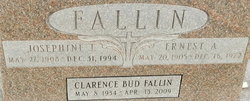
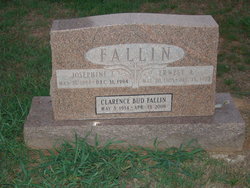
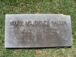
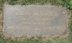
Josephine J McJimsey Fallin
| Birth | : | 7 May 1908 |
| Death | : | 31 Dec 1994 Spavinaw, Mayes County, Oklahoma, USA |
| Burial | : | Machpelah Cemetery, Weston, Lewis County, USA |
| Coordinate | : | 39.0475400, -80.4640760 |
| Plot | : | Section B, lot 23 |
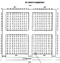
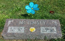
| Description | : | JOSEPHINE J FALLIN 27 May 1908 Dec 1994 74366 (Spavinaw, Mayes, OK) 573-16-0834 California The map furnished to me by the cemetery office. Marked the spot where her grave will be found. As you are looking in from the street, the top under the name is facing the south. To the left would be east, and right would be west. The first drive you come to is the entrance, marked so, and the other two are marked exits...If you were traveling west on Mount Vernon Street. |
frequently asked questions (FAQ):
-
Where is Josephine J McJimsey Fallin's memorial?
Josephine J McJimsey Fallin's memorial is located at: Machpelah Cemetery, Weston, Lewis County, USA.
-
When did Josephine J McJimsey Fallin death?
Josephine J McJimsey Fallin death on 31 Dec 1994 in Spavinaw, Mayes County, Oklahoma, USA
-
Where are the coordinates of the Josephine J McJimsey Fallin's memorial?
Latitude: 39.0475400
Longitude: -80.4640760
Family Members:
Parent
Spouse
Siblings
Children
Flowers:


Nearby Cemetories:
1. Machpelah Cemetery
Weston, Lewis County, USA
Coordinate: 39.0475400, -80.4640760
2. Weston State Hospital Cemetery
Weston, Lewis County, USA
Coordinate: 39.0395050, -80.4727760
3. Old Arnold Cemetery
Weston, Lewis County, USA
Coordinate: 39.0350120, -80.4693550
4. Butcher Cemetery
Turnertown, Lewis County, USA
Coordinate: 39.0727997, -80.4614029
5. Smith Family Cemetery
Lewis County, USA
Coordinate: 39.0457993, -80.4297028
6. Forest Lawn Memorial Gardens
Jane Lew, Lewis County, USA
Coordinate: 39.0649986, -80.4328003
7. Dutch Hollow Road Cemetery
Lewis County, USA
Coordinate: 39.0730330, -80.4860520
8. Brownsville Cemetery
Lewis County, USA
Coordinate: 39.0163994, -80.4756012
9. Gee Lick Cemetery
Weston, Lewis County, USA
Coordinate: 39.0787170, -80.4761610
10. Waldeck Cemetery
Waldeck, Lewis County, USA
Coordinate: 39.0486860, -80.5095950
11. Smiths Run Cemetery
Weston, Lewis County, USA
Coordinate: 39.0463070, -80.4173810
12. Peterson Cemetery
Weston, Lewis County, USA
Coordinate: 39.0224991, -80.4244003
13. Lewis County Memorial Gardens
Weston, Lewis County, USA
Coordinate: 39.0224390, -80.4202340
14. Middle Run Cemetery
Weston, Lewis County, USA
Coordinate: 39.0149994, -80.5081024
15. Thomas Law Cemetery
Jane Lew, Lewis County, USA
Coordinate: 39.0893270, -80.4326240
16. Fisher Cemetery
Weston, Lewis County, USA
Coordinate: 39.0331001, -80.5239029
17. Hicks Cemetery
Lewis County, USA
Coordinate: 39.0717010, -80.4077988
18. Jackson Cemetery
Jackson Mill, Lewis County, USA
Coordinate: 39.0974998, -80.4705963
19. Bush Cemetery
Horner, Lewis County, USA
Coordinate: 39.0147018, -80.4021988
20. Ward Cemetery
Lewis County, USA
Coordinate: 38.9975860, -80.5051990
21. Bailey Cemetery
Westfield, Lewis County, USA
Coordinate: 39.1067470, -80.4560270
22. Mount Hebron Cemetery
Jane Lew, Lewis County, USA
Coordinate: 39.1060982, -80.4255981
23. Glady Cemetery
Horner, Lewis County, USA
Coordinate: 38.9846992, -80.4389038
24. Freemansburg Baptist Cemetery
Freemansburg, Lewis County, USA
Coordinate: 39.0903750, -80.5290080