
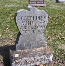
Josephine M. Edwards Aumiller
| Birth | : | 22 Jun 1884 |
| Death | : | 11 Oct 1912 |
| Burial | : | Onida Cemetery, Onida, Sully County, USA |
| Coordinate | : | 44.7147000, -100.0650000 |
| Plot | : | SECTION 5 east |
| Description | : | Soldier Valley. ... Mrs. Josephine Aumiller was stricken with paralysis on Friday, October 4, and lingered until October 11, 1912 .... The remains were laid to rest in the Holton cemetery. She leaves to mourn her departure, husband and two dear little sons, father, mother, and a brother and sister .... Holton Recorder, October 17, 1912. |
frequently asked questions (FAQ):
-
Where is Josephine M. Edwards Aumiller's memorial?
Josephine M. Edwards Aumiller's memorial is located at: Onida Cemetery, Onida, Sully County, USA.
-
When did Josephine M. Edwards Aumiller death?
Josephine M. Edwards Aumiller death on 11 Oct 1912 in
-
Where are the coordinates of the Josephine M. Edwards Aumiller's memorial?
Latitude: 44.7147000
Longitude: -100.0650000
Family Members:
Parent
Siblings
Children
Flowers:


Nearby Cemetories:
1. Onida Cemetery
Onida, Sully County, USA
Coordinate: 44.7147000, -100.0650000
2. Holy Rosary Cemetery
Agar, Sully County, USA
Coordinate: 44.8380000, -100.0616000
3. Schreiber Cemetery
Agar, Sully County, USA
Coordinate: 44.8821983, -100.1196976
4. Pleasant Hill Cemetery
Blunt, Hughes County, USA
Coordinate: 44.5135994, -100.0156021
5. Pleasant Cemetery
Sully County, USA
Coordinate: 44.6927986, -99.7568970
6. Okobojo Cemetery
Sully County, USA
Coordinate: 44.6568985, -100.3647003
7. Byron Township Cemetery
Blunt, Hughes County, USA
Coordinate: 44.4979200, -100.1904700
8. Blair Cemetery
Sully County, USA
Coordinate: 44.8027992, -100.4199982
9. Petro Family Cemetery
Gettysburg, Potter County, USA
Coordinate: 44.9706825, -100.2259903
10. Sacred Heart Cemetery
Gettysburg, Potter County, USA
Coordinate: 44.9982986, -99.9377975
11. Medicine Hill Cemetery
Harrold, Hughes County, USA
Coordinate: 44.5116997, -99.7453003
12. Copp Cemetery
Potter County, USA
Coordinate: 44.9118935, -99.7358236
13. Saint John Catholic Cemetery
Harrold, Hughes County, USA
Coordinate: 44.5127983, -99.7335968
14. Gettysburg Memorial Cemetery
Gettysburg Township, Potter County, USA
Coordinate: 45.0208146, -99.9898400
15. Canning Cemetery
Hughes County, USA
Coordinate: 44.3986890, -100.0278460
16. Gettysburg Cemetery
Gettysburg, Potter County, USA
Coordinate: 45.0149994, -99.9199982
17. Forest City Cemetery (Defunct)
Forest City, Potter County, USA
Coordinate: 45.0239900, -100.2667000
18. Mount Calvary Cemetery
Pierre, Hughes County, USA
Coordinate: 44.4197006, -100.3557968
19. Spring Lake Cemetery
Hyde County, USA
Coordinate: 44.7942009, -99.5610962
20. Riverside Cemetery
Pierre, Hughes County, USA
Coordinate: 44.3608017, -100.3071976
21. Scotty Philip Cemetery
Fort Pierre, Stanley County, USA
Coordinate: 44.4019012, -100.4036026
22. Fort Pierre Chouteau Cemetery
Fort Pierre, Stanley County, USA
Coordinate: 44.3908700, -100.3878300
23. South Dakota State Capitol Grounds
Pierre, Hughes County, USA
Coordinate: 44.3660100, -100.3448000
24. Lebanon Cemetery
Lebanon, Potter County, USA
Coordinate: 45.0635500, -99.7768400