
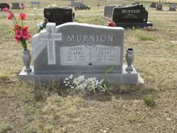
Juanita Lyonors Grant Murnion
| Birth | : | 6 Jan 1922 Montana, USA |
| Death | : | 1 Aug 2018 Miles City, Custer County, Montana, USA |
| Burial | : | Pioneer Cemetery, Jordan, Garfield County, USA |
| Coordinate | : | 47.3244019, -106.9238968 |
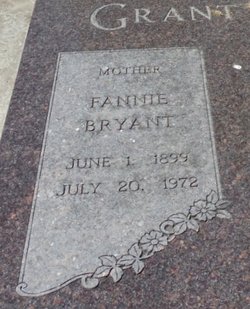
| Description | : | Lyonors Grant Murnion, age 96, of Jordan passed away on Wednesday, August 1, 2018 at the Holy Rosary Extended Care surrounded by her family. Juanita Lyonors Grant was born to Fannie Bryant and Ray Grant in the teacherage at Phon, Montana. Her father was the school teacher. She always remembered fondly her early childhood at the family farm on Woody Creek. In 1931, the family moved to Jordan where she attended school, through high school graduation in 1938. In the autumn of her 16th year, she entered Montana State University in Missoula. She worked in a... Read More |
frequently asked questions (FAQ):
-
Where is Juanita Lyonors Grant Murnion's memorial?
Juanita Lyonors Grant Murnion's memorial is located at: Pioneer Cemetery, Jordan, Garfield County, USA.
-
When did Juanita Lyonors Grant Murnion death?
Juanita Lyonors Grant Murnion death on 1 Aug 2018 in Miles City, Custer County, Montana, USA
-
Where are the coordinates of the Juanita Lyonors Grant Murnion's memorial?
Latitude: 47.3244019
Longitude: -106.9238968
Family Members:
Parent
Spouse

Siblings
Flowers:


Nearby Cemetories:
1. Pioneer Cemetery
Jordan, Garfield County, USA
Coordinate: 47.3244019, -106.9238968
2. Greenridge Cemetery
Jordan, Garfield County, USA
Coordinate: 47.3389015, -106.8946991
3. Hinther Cemetery
Garfield County, USA
Coordinate: 47.2685000, -107.0218000
4. Butte Creek Cemetery
Garfield County, USA
Coordinate: 47.4777985, -107.2341995
5. Steve Forks Cemetery
Garfield County, USA
Coordinate: 47.2627983, -107.3321991
6. Cohagen Cemetery
Cohagen, Garfield County, USA
Coordinate: 47.0772018, -106.6232986
7. Darnall-Armbruster-Hubbard Family Cemetery
Garfield County, USA
Coordinate: 47.6407000, -107.0645200
8. Neudorfer Cemetery
Jordan, Garfield County, USA
Coordinate: 47.2095000, -106.2772000
9. Hearts at Peace Cemetery
Brusett, Garfield County, USA
Coordinate: 47.5441900, -107.5399200
10. Wolf Cemetery
Garfield County, USA
Coordinate: 47.1528015, -107.5924988
11. Vanstel Cemetery
Rosebud County, USA
Coordinate: 46.7872009, -106.8942032
12. Haglunds Ritchie Cemetery
McCone County, USA
Coordinate: 47.3246994, -106.0639038
13. Biebers Cemetery
McCone County, USA
Coordinate: 47.2386100, -106.0348800
14. Biebers Cemetery
McCone County, USA
Coordinate: 47.2257600, -106.0220400
15. Watkins Cemetery
McCone County, USA
Coordinate: 47.1808014, -105.9811020
16. Coon Cemetery
Garfield County, USA
Coordinate: 47.3263790, -107.9323320
17. Gilfeather Cemetery
Benzien, Garfield County, USA
Coordinate: 47.2348310, -107.9476920
18. Fort Peck Cemetery
Valley County, USA
Coordinate: 48.0069008, -106.4599991
19. Rock Springs Cemetery
Rock Springs, Rosebud County, USA
Coordinate: 46.7847800, -106.1411500
20. Fort Peck Dam Disaster Memorial
Valley County, USA
Coordinate: 48.0083000, -106.4003000
21. Brockway Cemetery
McCone County, USA
Coordinate: 47.2963982, -105.7514038
22. Brost Cemetery
McCone County, USA
Coordinate: 47.2971992, -105.7457962
23. Galpin Cemetery
Valley County, USA
Coordinate: 48.0732994, -106.4692001
24. Sumatra Cemetery
Rosebud County, USA
Coordinate: 46.6136017, -107.5674973