
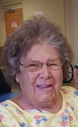

Judith Lorraine “Judy” Dignan Hauser
| Birth | : | 28 Sep 1943 Oakland, Garrett County, Maryland, USA |
| Death | : | 13 May 2019 Oakland, Garrett County, Maryland, USA |
| Burial | : | Franklin Cemetery, Franklin, Brooke County, USA |
| Coordinate | : | 40.2758800, -80.5449300 |
| Description | : | Judith “Judy” Lorraine (Dignan) Hauser, 75, of Red House, passed away on Monday, May 13, 2019 at Oakland Nursing and Rehabilitation. Born on September 28, 1943, in Oakland, she was the daughter of the late Thomas Nelson and Vera Francis (Wildensen) Dignan. Judy was a member of St. John’s Lutheran Church, Red House where she was a member of Ladies Sewing Circle. She has been a resident of Oakland Nursing and Rehab Center for the past year and a half. Before that, she was a homemaker and enjoyed quilting, word and number search puzzles, reading and watching Jeopardy and Wheel... Read More |
frequently asked questions (FAQ):
-
Where is Judith Lorraine “Judy” Dignan Hauser's memorial?
Judith Lorraine “Judy” Dignan Hauser's memorial is located at: Franklin Cemetery, Franklin, Brooke County, USA.
-
When did Judith Lorraine “Judy” Dignan Hauser death?
Judith Lorraine “Judy” Dignan Hauser death on 13 May 2019 in Oakland, Garrett County, Maryland, USA
-
Where are the coordinates of the Judith Lorraine “Judy” Dignan Hauser's memorial?
Latitude: 40.2758800
Longitude: -80.5449300
Family Members:
Parent
Spouse
Children
Flowers:


Nearby Cemetories:
1. Franklin Cemetery
Franklin, Brooke County, USA
Coordinate: 40.2758800, -80.5449300
2. St John's Cemetery
Brooke County, USA
Coordinate: 40.2697156, -80.5840881
3. Ebenezer Church Cemetery
Brooke County, USA
Coordinate: 40.3071090, -80.5622320
4. Lower Buffalo Cemetery
Brooke County, USA
Coordinate: 40.2435989, -80.5297012
5. Cross Creek Cemetery
Brooke County, USA
Coordinate: 40.3060989, -80.5792007
6. Knights of Saint George Cemetery
Wellsburg, Brooke County, USA
Coordinate: 40.2859920, -80.5989860
7. Independence Cemetery
Independence, Washington County, USA
Coordinate: 40.2531013, -80.4916992
8. Brooke Cemetery
Wellsburg, Brooke County, USA
Coordinate: 40.2874985, -80.6053009
9. Brooke County Public Library Cremation Niches
Wellsburg, Brooke County, USA
Coordinate: 40.2725410, -80.6128480
10. Unidentified Cemetery
McKinleyville, Brooke County, USA
Coordinate: 40.2402083, -80.5980333
11. Oak Grove Cemetery
Follansbee, Brooke County, USA
Coordinate: 40.3274994, -80.5766983
12. Bethel Methodist Protestant Church Cemetery
Washington County, USA
Coordinate: 40.3152700, -80.4889800
13. Georges Run Cemetery
Steubenville, Jefferson County, USA
Coordinate: 40.3022920, -80.6189630
14. Historic Bethany Church of Christ Cemetery
Bethany, Brooke County, USA
Coordinate: 40.2063866, -80.5542908
15. Bethany Church of Christ Cemetery
Bethany, Brooke County, USA
Coordinate: 40.2061730, -80.5539410
16. Campbell Cemetery
Bethany, Brooke County, USA
Coordinate: 40.2054430, -80.5467340
17. Bethany Community Cemetery
Brooke County, USA
Coordinate: 40.2054130, -80.5477620
18. Cross Creek United Presbyterian Church Cemetery
Colliers, Brooke County, USA
Coordinate: 40.3458430, -80.5316650
19. Saint John Cemetery Haven of Rest
Colliers, Brooke County, USA
Coordinate: 40.3486160, -80.5502720
20. Saint Andrews Cemetery
Mingo Junction, Jefferson County, USA
Coordinate: 40.3250008, -80.6172028
21. West Point Cemetery
Avella, Washington County, USA
Coordinate: 40.2891500, -80.4457700
22. Oakland Cemetery
Mingo Junction, Jefferson County, USA
Coordinate: 40.3285790, -80.6184240
23. Saint Johns Cemetery
Avella, Washington County, USA
Coordinate: 40.2893000, -80.4447300
24. Saint Michael Cemetery
Avella, Washington County, USA
Coordinate: 40.2902800, -80.4443600