
| Memorials | : | 5 |
| Location | : | Steubenville, Jefferson County, USA |
| Coordinate | : | 40.3022920, -80.6189630 |
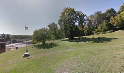
| Description | : | The cemetery is located on the south side of Harmony Alley about 200 feet west of its intersection with South Commercial Avenue. The cemetery is located in Steubenville Township, Jefferson County, Ohio, and is # 6096 (Point View Cemetery / Georges Run Cemetery / Harmony Cemetery) in “Ohio Cemeteries 1803-2003”, compiled by the Ohio Genealogical Society. The cemetery is registered with the Ohio Division of Real Estate and Professional Licensing (ODRE) as Point View Cemetery with registration license number CGR.0000980380. The U.S. Geological Survey (USGS) Geographic Names Information System (GNIS) feature ID for the cemetery is 1961689 (Georges Run... Read More |
frequently asked questions (FAQ):
-
Where is Georges Run Cemetery?
Georges Run Cemetery is located at Hamony Alley Steubenville, Jefferson County ,Ohio , 43938USA.
-
Georges Run Cemetery cemetery's updated grave count on graveviews.com?
5 memorials
-
Where are the coordinates of the Georges Run Cemetery?
Latitude: 40.3022920
Longitude: -80.6189630
Nearby Cemetories:
1. Brooke Cemetery
Wellsburg, Brooke County, USA
Coordinate: 40.2874985, -80.6053009
2. Knights of Saint George Cemetery
Wellsburg, Brooke County, USA
Coordinate: 40.2859920, -80.5989860
3. Saint Andrews Cemetery
Mingo Junction, Jefferson County, USA
Coordinate: 40.3250008, -80.6172028
4. Hill Cemetery
Steubenville, Jefferson County, USA
Coordinate: 40.3233490, -80.6353580
5. Oakland Cemetery
Mingo Junction, Jefferson County, USA
Coordinate: 40.3285790, -80.6184240
6. Brooke County Public Library Cremation Niches
Wellsburg, Brooke County, USA
Coordinate: 40.2725410, -80.6128480
7. Cross Creek Cemetery
Brooke County, USA
Coordinate: 40.3060989, -80.5792007
8. Oak Grove Cemetery
Follansbee, Brooke County, USA
Coordinate: 40.3274994, -80.5766983
9. St John's Cemetery
Brooke County, USA
Coordinate: 40.2697156, -80.5840881
10. Ebenezer Church Cemetery
Brooke County, USA
Coordinate: 40.3071090, -80.5622320
11. New Alexandria Cemetery
New Alexandria, Jefferson County, USA
Coordinate: 40.2949982, -80.6781006
12. Buckingham Cemetery
Wells Township, Jefferson County, USA
Coordinate: 40.2739230, -80.6662180
13. Highland Hills Memorial Gardens
Follansbee, Brooke County, USA
Coordinate: 40.3579480, -80.6038500
14. Franklin Cemetery
Franklin, Brooke County, USA
Coordinate: 40.2758800, -80.5449300
15. Everson Family Cemetery
Salt Run, Jefferson County, USA
Coordinate: 40.2492340, -80.6633810
16. Union Cemetery
Steubenville, Jefferson County, USA
Coordinate: 40.3636017, -80.6399994
17. Unidentified Cemetery
McKinleyville, Brooke County, USA
Coordinate: 40.2402083, -80.5980333
18. Mount Calvary Cemetery
Steubenville, Jefferson County, USA
Coordinate: 40.3643990, -80.6466980
19. McGee-Stringers Cemetery
Wells Township, Jefferson County, USA
Coordinate: 40.2431440, -80.6590810
20. Saint John Cemetery Haven of Rest
Colliers, Brooke County, USA
Coordinate: 40.3486160, -80.5502720
21. Cross Creek Cemetery
Wintersville, Jefferson County, USA
Coordinate: 40.3492928, -80.6872635
22. Tomb of the Unborn Child
Steubenville, Jefferson County, USA
Coordinate: 40.3753230, -80.6199840
23. Bnai Israel Cemetery
Steubenville, Jefferson County, USA
Coordinate: 40.3744011, -80.6572037
24. Cross Creek United Presbyterian Church Cemetery
Colliers, Brooke County, USA
Coordinate: 40.3458430, -80.5316650