


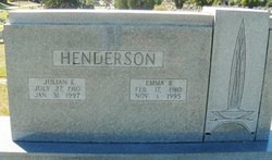
Julian Elliot “Dude” Henderson
| Birth | : | 27 Jul 1910 Montgomery County, Virginia, USA |
| Death | : | 31 Jan 1997 Blacksburg, Montgomery County, Virginia, USA |
| Burial | : | Christ Church Churchyard, Port Sunlight, Metropolitan Borough of Wirral, England |
| Coordinate | : | 53.3534920, -2.9953750 |
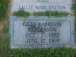
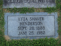
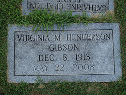
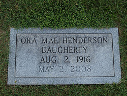
| Description | : | Julian E. Henderson, (Dude), 86, of Blacksburg, died Friday, January 31, 1997, at Greenwood Assisted Living Blacksburg. He wa s born in Montgomery County on July 27, 1910, to the late Giles Harrison and Eatta Shaver Henderson. He was a member of the Local 491 Union of Plumbers and Steam Fitters in Roanoke, and a member of the Blacksburg Fish and Game Commission for many years. He was preceded in death by his wife, Emma Jennette Henderson. Surviving are three sisters, Minnie H. Elliott, Virginia H. Gibson and Ora Mae H. Daugherty, all of Christiansburg; one brother, Rudolph (Tete) Henderson,... Read More |
frequently asked questions (FAQ):
-
Where is Julian Elliot “Dude” Henderson's memorial?
Julian Elliot “Dude” Henderson's memorial is located at: Christ Church Churchyard, Port Sunlight, Metropolitan Borough of Wirral, England.
-
When did Julian Elliot “Dude” Henderson death?
Julian Elliot “Dude” Henderson death on 31 Jan 1997 in Blacksburg, Montgomery County, Virginia, USA
-
Where are the coordinates of the Julian Elliot “Dude” Henderson's memorial?
Latitude: 53.3534920
Longitude: -2.9953750
Family Members:
Parent
Spouse
Siblings
Flowers:


Nearby Cemetories:
1. Christ Church Churchyard
Port Sunlight, Metropolitan Borough of Wirral, England
Coordinate: 53.3534920, -2.9953750
2. St Andrews Parish Churchyard
Bebington, Metropolitan Borough of Wirral, England
Coordinate: 53.3479800, -3.0035400
3. Bebington Cemetery
Bebington, Metropolitan Borough of Wirral, England
Coordinate: 53.3588030, -3.0165370
4. St. Peter's Churchyard
Bebington, Metropolitan Borough of Wirral, England
Coordinate: 53.3692500, -3.0021020
5. Christ Church
Bebington, Metropolitan Borough of Wirral, England
Coordinate: 53.3584460, -3.0254810
6. St Barnabas Bromborough
Bromborough, Metropolitan Borough of Wirral, England
Coordinate: 53.3324700, -2.9784000
7. St Paul's
Tranmere, Metropolitan Borough of Wirral, England
Coordinate: 53.3740000, -3.0154600
8. Plymyard Cemetery
Bromborough, Metropolitan Borough of Wirral, England
Coordinate: 53.3207700, -2.9725400
9. St Michael's in the Hamlet
Aigburth, Metropolitan Borough of Liverpool, England
Coordinate: 53.3765870, -2.9499850
10. Ancient Chapel Of Toxteth Park
Liverpool, Metropolitan Borough of Liverpool, England
Coordinate: 53.3811568, -2.9575849
11. Mayfields Woodland Remembrance Park
Eastham, Metropolitan Borough of Wirral, England
Coordinate: 53.3255100, -2.9550200
12. St. Mary's Churchyard
Birkenhead, Metropolitan Borough of Wirral, England
Coordinate: 53.3895930, -3.0112520
13. St. Werburgh & St. Laurence Catholic Churchyard
Birkenhead, Metropolitan Borough of Wirral, England
Coordinate: 53.3894910, -3.0217530
14. St. Anne's Churchyard
Aigburth, Metropolitan Borough of Liverpool, England
Coordinate: 53.3695480, -2.9305760
15. St. James Churchyard
Toxteth, Metropolitan Borough of Liverpool, England
Coordinate: 53.3943720, -2.9750688
16. Wesleyan Methodist Chapel Graveyard
Liverpool, Metropolitan Borough of Liverpool, England
Coordinate: 53.3940590, -2.9719160
17. All Saints Churchyard
Thornton Hough, Metropolitan Borough of Wirral, England
Coordinate: 53.3203500, -3.0444780
18. St James Garden Cemetery
Liverpool, Metropolitan Borough of Liverpool, England
Coordinate: 53.3960744, -2.9715005
19. St. Mary's Churchyard
Eastham, Metropolitan Borough of Wirral, England
Coordinate: 53.3133500, -2.9614500
20. St. Michaels Churchyard
Liverpool, Metropolitan Borough of Liverpool, England
Coordinate: 53.3976599, -2.9789353
21. Liverpool Cathedral
Liverpool, Metropolitan Borough of Liverpool, England
Coordinate: 53.3974310, -2.9731610
22. St. Thomas Churchyard
Liverpool, Metropolitan Borough of Liverpool, England
Coordinate: 53.4010330, -2.9861190
23. St Austin's Churchyard
Grassendale, Metropolitan Borough of Liverpool, England
Coordinate: 53.3614552, -2.9124587
24. St Matthew & St James Churchyard
Mossley Hill, Metropolitan Borough of Liverpool, England
Coordinate: 53.3764200, -2.9204740