


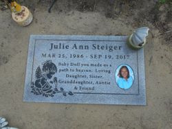
Julie Ann Steiger
| Birth | : | 25 Mar 1986 Libby, Lincoln County, Montana, USA |
| Death | : | 19 Sep 2017 |
| Burial | : | Troy Cemetery, Troy, Lincoln County, USA |
| Coordinate | : | 48.4752330, -115.8992710 |
| Description | : | JULIE A STEIGER March 25, 1986 ~ September 19, 2017 (age 31) Julie A. Steiger, 31, of Troy, MT passed away Tuesday, September 19, 2017, as a result of injuries sustained in a motor vehicle accident. She was born March 25, 1986 in Libby, MT to Terry Lee and Tami Marie (Morse) Steiger. Julie grew up and attended elementary and high school in Troy, graduating with the Class of 2004. Following high school, she attended college at Montana State in Bozeman. She completed 2 ½ years of college, working towards a teaching degree. Julie... Read More |
frequently asked questions (FAQ):
-
Where is Julie Ann Steiger's memorial?
Julie Ann Steiger's memorial is located at: Troy Cemetery, Troy, Lincoln County, USA.
-
When did Julie Ann Steiger death?
Julie Ann Steiger death on 19 Sep 2017 in
-
Where are the coordinates of the Julie Ann Steiger's memorial?
Latitude: 48.4752330
Longitude: -115.8992710
Family Members:
Parent
Flowers:


Nearby Cemetories:
1. Troy Cemetery
Troy, Lincoln County, USA
Coordinate: 48.4752330, -115.8992710
2. Milnor Lake Cemetery
Troy, Lincoln County, USA
Coordinate: 48.4181150, -115.8259500
3. Larchwood Cemetery
Lincoln County, USA
Coordinate: 48.4178009, -115.8257980
4. Winn Family Cemetery
Lincoln County, USA
Coordinate: 48.5488590, -115.9644710
5. Leonia Cemetery
Leonia, Boundary County, USA
Coordinate: 48.6161720, -116.0497860
6. Boulder Creek Cemetery
Boundary County, USA
Coordinate: 48.6194000, -116.0571976
7. Bull Lake Guest Ranch Cemetery
Troy, Lincoln County, USA
Coordinate: 48.2424940, -115.8275090
8. Libby Cemetery
Libby, Lincoln County, USA
Coordinate: 48.3893540, -115.5646380
9. Sylvanite Cemetery
Lincoln County, USA
Coordinate: 48.7210000, -115.8745000
10. Parker Family Cemetery
Boundary County, USA
Coordinate: 48.6665200, -116.2619200
11. Paradise Valley Cemetery
Bonners Ferry, Boundary County, USA
Coordinate: 48.6453018, -116.3080978
12. Grandview Cemetery
Bonners Ferry, Boundary County, USA
Coordinate: 48.6851300, -116.2932700
13. Holy Myrrhbearers Orthodox Church Parish Cemetery
Bonners Ferry, Boundary County, USA
Coordinate: 48.6190260, -116.3598830
14. Cloudledge Cemetery
East Hope, Bonner County, USA
Coordinate: 48.2345670, -116.2772340
15. Hope Cemetery
East Hope, Bonner County, USA
Coordinate: 48.2449989, -116.2966995
16. Gold Creek Cemetery
Bonner County, USA
Coordinate: 48.4000015, -116.4160995
17. Old Hope Cemetery
Hope, Bonner County, USA
Coordinate: 48.2530500, -116.3157300
18. McArthur Cemetery
Boundary County, USA
Coordinate: 48.5246000, -116.4350000
19. Owen Family Cemetery
East Hope, Bonner County, USA
Coordinate: 48.2160100, -116.2790200
20. Clark Fork Cemetery
Clark Fork, Bonner County, USA
Coordinate: 48.1610000, -116.1690000
21. Moravia Cemetery
Moravia, Boundary County, USA
Coordinate: 48.6591988, -116.3741989
22. Woodland Mennonite Church Cemetery
Bonners Ferry, Boundary County, USA
Coordinate: 48.7010470, -116.3335570
23. Mountain View Mennonite Cemetery
Bonners Ferry, Boundary County, USA
Coordinate: 48.7389000, -116.2968000
24. Pack River Cemetery
Bonner County, USA
Coordinate: 48.3675620, -116.4404120