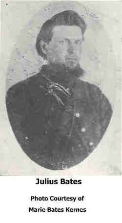
Julius Bates
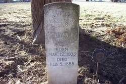
| Birth | : | 12 Mar 1833 Noble County, Ohio, USA |
| Death | : | 5 Feb 1888 |
| Burial | : | Woodstock Rural Cemetery, Woodstock, Carleton County, Canada |
| Coordinate | : | 46.1493600, -67.5999500 |
| Description | : | Civil War Veteran Co C 17th Iowa Infantry From military records: Bates, Julius. Age 29. Residence Keokuk,Ia nativity Ohio. Enlisted Feb. 28, 1862. Mustered March 29, 1862 Keokuk,Ia. Promoted Corporal. Discharged March 12, 1863, Mound City. Ill.(Note - Probably due to a chronic illness since military hospitals located in Mound City) Service of the 17th Iowa Infantry during his enlistment included the Siege of Corinth,MS(May 1862), battle of Iuka (Sep 19) and battle of Corinth (Oct 3-4). The Union was outnumbered more than 3 to 1 by attacking Confederate forces (approx 10,000) at Battle of Corinth. However the Union still held... Read More |
frequently asked questions (FAQ):
-
Where is Julius Bates's memorial?
Julius Bates's memorial is located at: Woodstock Rural Cemetery, Woodstock, Carleton County, Canada.
-
When did Julius Bates death?
Julius Bates death on 5 Feb 1888 in
-
Where are the coordinates of the Julius Bates's memorial?
Latitude: 46.1493600
Longitude: -67.5999500
Family Members:
Parent
Spouse
Siblings
Children
Flowers:
Nearby Cemetories:
1. Woodstock Rural Cemetery
Woodstock, Carleton County, Canada
Coordinate: 46.1493600, -67.5999500
2. Calvary Catholic Cemetery
Woodstock, Carleton County, Canada
Coordinate: 46.1507300, -67.5937700
3. Methodist Cemetery
Woodstock, Carleton County, Canada
Coordinate: 46.1457500, -67.5792500
4. St. Gertrude's Roman Catholic Church Cemetery
Woodstock, Carleton County, Canada
Coordinate: 46.1448830, -67.5795080
5. Upper Woodstock Cemetery
Upper Woodstock, Carleton County, Canada
Coordinate: 46.1716500, -67.5737900
6. Grafton Cemetery
Grafton, Carleton County, Canada
Coordinate: 46.1683697, -67.5627304
7. Bedell Settlement Cemetery
Bedell Settlement, Carleton County, Canada
Coordinate: 46.1331010, -67.6539630
8. Jacksonville Anglican Cemetery
Jacksonville, Carleton County, Canada
Coordinate: 46.1918800, -67.6055900
9. Anglican Cemetery
Woodstock, Carleton County, Canada
Coordinate: 46.1086968, -67.5684877
10. Haynes Family Cemetery
Richmond Corner, Carleton County, Canada
Coordinate: 46.1504810, -67.6752390
11. Jacksonville Community Cemetery
Jacksonville, Carleton County, Canada
Coordinate: 46.2024800, -67.6112400
12. Pembroke Cemetery
Pembroke, Carleton County, Canada
Coordinate: 46.1933710, -67.5344050
13. St. John's Anglican Cemetery
Richmond Corner, Carleton County, Canada
Coordinate: 46.1458400, -67.7014780
14. Richmond Corner United Church Cemetery
Richmond Corner, Carleton County, Canada
Coordinate: 46.1405890, -67.7079940
15. Wakefield Community Cemetery
Wakefield, Carleton County, Canada
Coordinate: 46.2103590, -67.5287590
16. Pioneer Cemetery
Lower Wakefield, Carleton County, Canada
Coordinate: 46.2139200, -67.5247300
17. Saint John's United Church Cemetery
McKenzie Corner, Carleton County, Canada
Coordinate: 46.1016580, -67.7184300
18. Lower Brighton Cemetery
Lower Brighton, Carleton County, Canada
Coordinate: 46.2198060, -67.5057780
19. McKenzie Corner Presbyterian Cemetery
McKenzie Corner, Carleton County, Canada
Coordinate: 46.1017400, -67.7236900
20. Lindsay United Baptist Church Cemetery
Lindsay, Carleton County, Canada
Coordinate: 46.2327740, -67.6785000
21. McKenzie Corner United Baptist Cemetery
McKenzie Corner, Carleton County, Canada
Coordinate: 46.1002730, -67.7256850
22. Jacksontown Cemetery
Jacksontown, Carleton County, Canada
Coordinate: 46.2490500, -67.6202300
23. Northampton Kirk Cemetery
Woodstock, Carleton County, Canada
Coordinate: 46.0525000, -67.5535000
24. Angel's Among Us Pet Cemetery
Watson Settlement, Carleton County, Canada
Coordinate: 46.1764470, -67.7424990

