
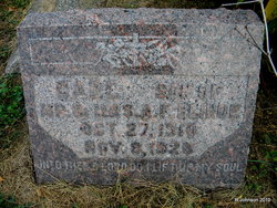
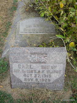
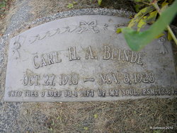
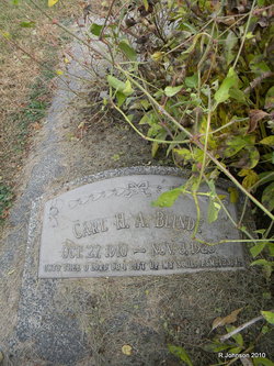
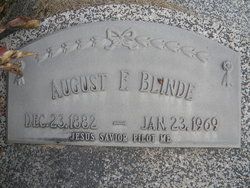
Karl Herman August Blinde
| Birth | : | 27 Oct 1910 Johnson, Nemaha County, Nebraska, USA |
| Death | : | 8 Nov 1928 Johnson, Nemaha County, Nebraska, USA |
| Burial | : | Mangatainoka Cemetery, Pahiatua, Tararua District, New Zealand |
| Coordinate | : | -40.4250620, 175.8597850 |
| Inscription | : | Grave Ledger: UNTO THEE O LORD DO I LIFT UP MY SOUL.PSM.123;1 Headstone: UNTO THEE O LORD DO I LIFT UP MY SOUL |
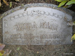
| Description | : | Karl Blinde, aged 20, son of Fritz Adolph August Blinde and Mary Anna (Knipplemeier) Blinde, who operate the hotel in Johnson, was in a tree trimming the branches on Thursday afternoon. He evidently struck a live wire, which shocked him and he fell to the ground, fracturing his ribs and puncturing a lung. He died that evening five hours after the accident. He was baptized on Nov. 27, 1910, at St. Mattthew Lutheran Church and was also confirmed there in 1925. |
frequently asked questions (FAQ):
-
Where is Karl Herman August Blinde's memorial?
Karl Herman August Blinde's memorial is located at: Mangatainoka Cemetery, Pahiatua, Tararua District, New Zealand.
-
When did Karl Herman August Blinde death?
Karl Herman August Blinde death on 8 Nov 1928 in Johnson, Nemaha County, Nebraska, USA
-
Where are the coordinates of the Karl Herman August Blinde's memorial?
Latitude: -40.4250620
Longitude: 175.8597850
Family Members:
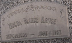
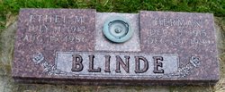
Parent
Siblings
Flowers:


Nearby Cemetories:
1. Mangatainoka Cemetery
Pahiatua, Tararua District, New Zealand
Coordinate: -40.4250620, 175.8597850
2. Mangahao Cemetery
Ballance, Tararua District, New Zealand
Coordinate: -40.4276820, 175.7890440
3. Kaitawa Cemetery
Kaitawa, Tararua District, New Zealand
Coordinate: -40.4939310, 175.8824710
4. Lawn Woodville Cemetery
Woodville, Tararua District, New Zealand
Coordinate: -40.3390540, 175.8807710
5. RSA Woodville Cemetery
Woodville, Tararua District, New Zealand
Coordinate: -40.3362310, 175.8345210
6. Old Gorge Cemetery
Woodville, Tararua District, New Zealand
Coordinate: -40.3361206, 175.8332520
7. Ashhurst Cemetery
Ashhurst, Palmerston North City, New Zealand
Coordinate: -40.3013600, 175.7576040
8. Kumeroa Cemetery
Kumeroa, Tararua District, New Zealand
Coordinate: -40.3294480, 176.0238960
9. Kelvin Grove Cemetery
Palmerston North, Palmerston North City, New Zealand
Coordinate: -40.3239060, 175.6616870
10. Terrace End Cemetery
Palmerston North, Palmerston North City, New Zealand
Coordinate: -40.3427170, 175.6433160
11. St Peter's Anglican Church
Roslyn, Palmerston North City, New Zealand
Coordinate: -40.3468897, 175.6279770
12. All Saint's Anglican Church
Palmerston North, Palmerston North City, New Zealand
Coordinate: -40.3581590, 175.6107926
13. Newman Cemetery
Eketahuna, Tararua District, New Zealand
Coordinate: -40.6154770, 175.7134490
14. Bunnythorpe Cemetery
Palmerston North, Palmerston North City, New Zealand
Coordinate: -40.2867770, 175.6272590
15. Tahoraiti Urupā
Dannevirke, Tararua District, New Zealand
Coordinate: -40.2428680, 176.0574580
16. First Cemetery of Eketahuna
Eketahuna, Tararua District, New Zealand
Coordinate: -40.6467990, 175.7136840
17. Alfredton Cemetery
Alfredton, Tararua District, New Zealand
Coordinate: -40.6808500, 175.8670160
18. Pohangina Cemetery
Pohangina, Manawatu District, New Zealand
Coordinate: -40.1682490, 175.7946660
19. Eketahuna Lawn Cemetery
Eketahuna, Tararua District, New Zealand
Coordinate: -40.6538700, 175.6883400
20. Calleson Family Cemetery
Palmerston North, Palmerston North City, New Zealand
Coordinate: -40.3814600, 175.5157840
21. Aorangi Urupā
Manawatu District, New Zealand
Coordinate: -40.2443660, 175.5870110
22. Pongaroa cemetery
Pahiatua, Tararua District, New Zealand
Coordinate: -40.5448890, 176.1975300
23. Settlers Cemetery
Dannevirke, Tararua District, New Zealand
Coordinate: -40.2046600, 176.1107900
24. Mangatera Cemetery
Dannevirke, Tararua District, New Zealand
Coordinate: -40.1883520, 176.1180990