
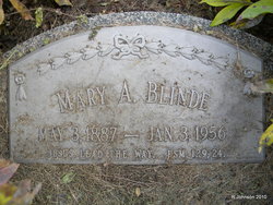
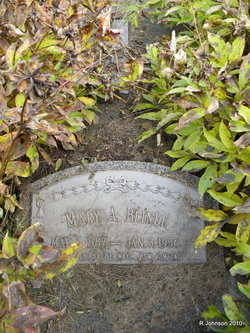

Mary Anna Knippelmeier Blinde
| Birth | : | 3 May 1887 Johnson, Nemaha County, Nebraska, USA |
| Death | : | 3 Jan 1956 Syracuse, Otoe County, Nebraska, USA |
| Burial | : | Castine Cemetery, Castine, Darke County, USA |
| Coordinate | : | 39.9306050, -84.6210650 |
| Inscription | : | JESUS LEAD THE WAY. PSM. 129; 24. |
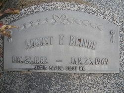
| Description | : | Mrs. August F. "Mary" Blinde, 68, of Johnson, Nebr. died at the Syracuse, Nebraska hospital. She was born at Febing (a community that no longer exists, believed to have been in Nemaha County), near the town of Johnson, Nebr. in Nemaha County. Her parents were Diedrich Herman Knippelmeier and Marie Wilhelmine Muhsmann. She was baptized on June 5, 1887, and confirmed on March 31, 1901, at St. Johns (Stone) Lutheran Church in rural Auburn, Nebr. She lived with her parents on a farm southwest of Johnson, Nebraska. She was married to Fritz Adolph August Blinde on... Read More |
frequently asked questions (FAQ):
-
Where is Mary Anna Knippelmeier Blinde's memorial?
Mary Anna Knippelmeier Blinde's memorial is located at: Castine Cemetery, Castine, Darke County, USA.
-
When did Mary Anna Knippelmeier Blinde death?
Mary Anna Knippelmeier Blinde death on 3 Jan 1956 in Syracuse, Otoe County, Nebraska, USA
-
Where are the coordinates of the Mary Anna Knippelmeier Blinde's memorial?
Latitude: 39.9306050
Longitude: -84.6210650
Family Members:
Parent
Spouse
Siblings

Children
Flowers:


Nearby Cemetories:
1. Castine Cemetery
Castine, Darke County, USA
Coordinate: 39.9306050, -84.6210650
2. Old Castine Cemetery
Castine, Darke County, USA
Coordinate: 39.9383011, -84.6250000
3. Railroad Cemetery
Castine, Darke County, USA
Coordinate: 39.9183410, -84.6244710
4. Brown Cemetery
West Manchester, Preble County, USA
Coordinate: 39.8950005, -84.5958328
5. Otterbein Cemetery
Otterbein, Darke County, USA
Coordinate: 39.9453270, -84.6705110
6. Ithaca Cemetery
Ithaca, Darke County, USA
Coordinate: 39.9431000, -84.5597000
7. Monroe Cemetery
Eldorado, Preble County, USA
Coordinate: 39.8878710, -84.6562140
8. Dry Fork Cemetery
West Manchester, Preble County, USA
Coordinate: 39.8795433, -84.6157150
9. Ithaca Lutheran Cemetery
Ithaca, Darke County, USA
Coordinate: 39.9357490, -84.5517200
10. Pleasant View Church Cemetery
Eldorado, Preble County, USA
Coordinate: 39.8860700, -84.6611710
11. Beech Grove Cemetery
Arcanum, Darke County, USA
Coordinate: 39.9907800, -84.6180000
12. Hamburg Cemetery
Hamburg, Preble County, USA
Coordinate: 39.8869320, -84.6791360
13. Wilt Cemetery
Darke County, USA
Coordinate: 39.9486008, -84.6992035
14. Wares Chapel Cemetery
West Manchester, Preble County, USA
Coordinate: 39.8644447, -84.6466675
15. Harter Cemetery
New Madison, Darke County, USA
Coordinate: 39.9747009, -84.6949997
16. Hunt Cemetery
West Sonora, Preble County, USA
Coordinate: 39.9100500, -84.5313400
17. Green Mound Cemetery
New Madison, Darke County, USA
Coordinate: 39.9627991, -84.7052994
18. First Universalist Church Cemetery
New Madison, Darke County, USA
Coordinate: 39.9667280, -84.7058340
19. Mills Cemetery
New Madison, Darke County, USA
Coordinate: 39.9947014, -84.6797028
20. Yankeetown Cemetery
Yankeetown, Darke County, USA
Coordinate: 39.9356003, -84.7230988
21. Wehrly Cemetery
Eldorado, Preble County, USA
Coordinate: 39.8598250, -84.6676020
22. Prices Creek German Baptist Cemetery
Hamburg, Preble County, USA
Coordinate: 39.8636017, -84.6771011
23. Old German Baptist Brethren Church Cemetery
Eldorado, Preble County, USA
Coordinate: 39.8636060, -84.6781430
24. Gordon Cemetery
Gordon, Darke County, USA
Coordinate: 39.9283840, -84.5063390