
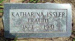
Katharina Litz Traudt
| Birth | : | 6 Aug 1861 Russia |
| Death | : | 14 Jul 1941 Sutton, Clay County, Nebraska, USA |
| Burial | : | Anglican Cemetery, Woodstock, Carleton County, Canada |
| Coordinate | : | 46.1086968, -67.5684877 |
| Description | : | Mrs. Katharina Traudt (born Litz) first saw light of the world on the 6th of August 1861 in Lichtental, Southern Russia, where she was also baptized and confirmed. In the year 1887 she entered the bonds of holy matrimony with Gottlieb Friedrich Issler. Two years later they came to America and settled down near Sutton, Nebraska where they lived until 1916. They left from Sutton to Fullerton, North Dakota, where they lived together until, in 1928, the Lord called her husband to join Him in eternity. On the 17th of April, 1932 she gave her hand in marriage... Read More |
frequently asked questions (FAQ):
-
Where is Katharina Litz Traudt's memorial?
Katharina Litz Traudt's memorial is located at: Anglican Cemetery, Woodstock, Carleton County, Canada.
-
When did Katharina Litz Traudt death?
Katharina Litz Traudt death on 14 Jul 1941 in Sutton, Clay County, Nebraska, USA
-
Where are the coordinates of the Katharina Litz Traudt's memorial?
Latitude: 46.1086968
Longitude: -67.5684877
Family Members:
Spouse
Children

Flowers:


Nearby Cemetories:
1. Anglican Cemetery
Woodstock, Carleton County, Canada
Coordinate: 46.1086968, -67.5684877
2. St. Gertrude's Roman Catholic Church Cemetery
Woodstock, Carleton County, Canada
Coordinate: 46.1448830, -67.5795080
3. Methodist Cemetery
Woodstock, Carleton County, Canada
Coordinate: 46.1457500, -67.5792500
4. Calvary Catholic Cemetery
Woodstock, Carleton County, Canada
Coordinate: 46.1507300, -67.5937700
5. Woodstock Rural Cemetery
Woodstock, Carleton County, Canada
Coordinate: 46.1493600, -67.5999500
6. Northampton Kirk Cemetery
Woodstock, Carleton County, Canada
Coordinate: 46.0525000, -67.5535000
7. Grafton Cemetery
Grafton, Carleton County, Canada
Coordinate: 46.1683697, -67.5627304
8. Upper Woodstock Cemetery
Upper Woodstock, Carleton County, Canada
Coordinate: 46.1716500, -67.5737900
9. Bedell Settlement Cemetery
Bedell Settlement, Carleton County, Canada
Coordinate: 46.1331010, -67.6539630
10. Haynes Family Cemetery
Richmond Corner, Carleton County, Canada
Coordinate: 46.1504810, -67.6752390
11. Hay Settlement United Church Cemetery
Meductic, York County, Canada
Coordinate: 46.0245300, -67.5391800
12. Jacksonville Anglican Cemetery
Jacksonville, Carleton County, Canada
Coordinate: 46.1918800, -67.6055900
13. Pembroke Cemetery
Pembroke, Carleton County, Canada
Coordinate: 46.1933710, -67.5344050
14. Saint Agnes Roman Catholic Cemetery
Debec, Carleton County, Canada
Coordinate: 46.0570170, -67.6875130
15. Jacksonville Community Cemetery
Jacksonville, Carleton County, Canada
Coordinate: 46.2024800, -67.6112400
16. St. John's Anglican Cemetery
Richmond Corner, Carleton County, Canada
Coordinate: 46.1458400, -67.7014780
17. Saint Andrew's United Church Cemetery
Oak Mountain, Carleton County, Canada
Coordinate: 46.0203600, -67.6400800
18. Richmond Corner United Church Cemetery
Richmond Corner, Carleton County, Canada
Coordinate: 46.1405890, -67.7079940
19. Saint John's United Church Cemetery
McKenzie Corner, Carleton County, Canada
Coordinate: 46.1016580, -67.7184300
20. Wakefield Community Cemetery
Wakefield, Carleton County, Canada
Coordinate: 46.2103590, -67.5287590
21. McKenzie Corner Presbyterian Cemetery
McKenzie Corner, Carleton County, Canada
Coordinate: 46.1017400, -67.7236900
22. McKenzie Corner United Baptist Cemetery
McKenzie Corner, Carleton County, Canada
Coordinate: 46.1002730, -67.7256850
23. Pioneer Cemetery
Lower Wakefield, Carleton County, Canada
Coordinate: 46.2139200, -67.5247300
24. Saint Joseph's Cemetery
Newburg, Carleton County, Canada
Coordinate: 46.1943700, -67.4666500