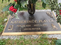
Katherine Jackson Player
| Birth | : | 28 Feb 1928 Holly Hill, Orangeburg County, South Carolina, USA |
| Death | : | 1 Sep 2010 Columbia, Richland County, South Carolina, USA |
| Burial | : | Terrace Grove Cemetery, Belen, Valencia County, USA |
| Coordinate | : | 34.6702995, -106.7844009 |
| Description | : | Orangeburg - Katherine Player, 82, of Orangeburg, passed away Wednesday, Sept. 1, 2010, at Palmetto Health Richland in Columbia. Funeral services will be 2 p.m. Saturday, Sept. 4, 2010 at Four Holes Baptist Church in Orangeburg, with the Rev. Tom McElhaney officiating. Burial will follow in Crestlawn Memorial Gardens. Active pallbearers will be her grandsons, Paul Carson, Kelvin Carson, Michael Carson, McLone Carson, Randall Carson, Patrick Dawson, Herbie Bishop and special grandson Wade Carson. Honorary pallbearers will be members of the Sybil Riley Sunday school class, Pat Garrick, John Crum, Tim Hartzog, Jackie Hydrick and Doug... Read More |
frequently asked questions (FAQ):
-
Where is Katherine Jackson Player's memorial?
Katherine Jackson Player's memorial is located at: Terrace Grove Cemetery, Belen, Valencia County, USA.
-
When did Katherine Jackson Player death?
Katherine Jackson Player death on 1 Sep 2010 in Columbia, Richland County, South Carolina, USA
-
Where are the coordinates of the Katherine Jackson Player's memorial?
Latitude: 34.6702995
Longitude: -106.7844009
Family Members:
Parent
Spouse
Siblings
Children
Flowers:
Nearby Cemetories:
1. Terrace Grove Cemetery
Belen, Valencia County, USA
Coordinate: 34.6702995, -106.7844009
2. Our Lady of Belen Memorial Gardens
Belen, Valencia County, USA
Coordinate: 34.6613998, -106.7835999
3. Saint Philip Columbarium
Los Lunas, Valencia County, USA
Coordinate: 34.6508530, -106.7329040
4. First United Methodist Church Columbarium
Belen, Valencia County, USA
Coordinate: 34.6556000, -106.7259000
5. Belen Mennonite Church Cemetery
Belen, Valencia County, USA
Coordinate: 34.6212800, -106.7081300
6. El Cemeterio de Los Ricos
Tome, Valencia County, USA
Coordinate: 34.7388790, -106.7325590
7. Tome Cemetery
Tome, Valencia County, USA
Coordinate: 34.7243996, -106.7071991
8. Immaculate Conception Church Cemetery
Tome, Valencia County, USA
Coordinate: 34.7417270, -106.7299250
9. Casa de Coloradas Cemetery
Casa Colorada, Valencia County, USA
Coordinate: 34.5770000, -106.7484000
10. Cristo Rey Cemetery
Bosque, Valencia County, USA
Coordinate: 34.5674530, -106.7999090
11. Seventh Day Adventist Cemetery
Los Lunas, Valencia County, USA
Coordinate: 34.7774840, -106.7105250
12. San Clemente Cemetery
Los Lunas, Valencia County, USA
Coordinate: 34.8059550, -106.7353750
13. San Antonio Cemetery
Sabinal, Socorro County, USA
Coordinate: 34.5287800, -106.7965200
14. San Clemente Cemetery
Los Lunas, Valencia County, USA
Coordinate: 34.8105000, -106.7424000
15. El Camposanto de la Liverta
Los Lunas, Valencia County, USA
Coordinate: 34.7905998, -106.6746979
16. Los Lunas Hospital And Training School Cemetery
Los Lunas, Valencia County, USA
Coordinate: 34.8198060, -106.7427210
17. San Antonio de los Lentes Cemetery
Los Lunas, Valencia County, USA
Coordinate: 34.8202200, -106.7412700
18. Los Lentes Cemetery
Los Lentes, Valencia County, USA
Coordinate: 34.8203011, -106.7406006
19. Sangre de Cristo Cemetery
Los Lunas, Valencia County, USA
Coordinate: 34.8100160, -106.6997550
20. Veguita Catholic Cemetery
Veguita, Socorro County, USA
Coordinate: 34.5126900, -106.7675700
21. Veguita Memorial Cemetery
Veguita, Socorro County, USA
Coordinate: 34.5124700, -106.7656600
22. Our Lady of Guadalupe Catholic Cemetery
Valencia, Valencia County, USA
Coordinate: 34.8136400, -106.6685300
23. Peralta and Valencia Cemetery
Peralta, Valencia County, USA
Coordinate: 34.8139000, -106.6678009
24. Chihuahua Bible Chapel Cemetery
Veguita, Socorro County, USA
Coordinate: 34.4903100, -106.7644900


