
| Birth | : | 6 Jul 1938 Boone County, Nebraska, USA |
| Death | : | 2 Apr 2008 Eagle, Cass County, Nebraska, USA |
| Burial | : | Evergreen Cemetery, Saint Edward, Boone County, USA |
| Coordinate | : | 41.5677986, -97.8411026 |
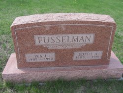
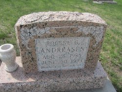
| Description | : | Daughter of Ira I. & Edith A. (Hammerlun) Fusselman. Married to Larry Reynoldson on 12-24-1958 at the Salem Lutheran Church in Platte County, NE. Survived by her husband Larry, daughter Kimberly and husband Keith Jacobsen, son Terrance and wife Kathy Reynoldson, grandson Christopher Reynoldson, granddaughters Kelsy Reynoldson, and Marissa Jacobsen, all of Eagle, sisters Ramona and husband Dale Bennet, of Fremont, and Doreen Gustafson, of St. Edward, |
frequently asked questions (FAQ):
-
Where is Kathleen Rae “Kay” Fusselman Reynoldson's memorial?
Kathleen Rae “Kay” Fusselman Reynoldson's memorial is located at: Evergreen Cemetery, Saint Edward, Boone County, USA.
-
When did Kathleen Rae “Kay” Fusselman Reynoldson death?
Kathleen Rae “Kay” Fusselman Reynoldson death on 2 Apr 2008 in Eagle, Cass County, Nebraska, USA
-
Where are the coordinates of the Kathleen Rae “Kay” Fusselman Reynoldson's memorial?
Latitude: 41.5677986
Longitude: -97.8411026
Family Members:
Parent

Siblings

Flowers:


Nearby Cemetories:
1. Evergreen Cemetery
Saint Edward, Boone County, USA
Coordinate: 41.5677986, -97.8411026
2. Saint Edward Catholic Cemetery
Saint Edward, Boone County, USA
Coordinate: 41.5684800, -97.8424800
3. Lingle Cemetery
Genoa, Nance County, USA
Coordinate: 41.5108000, -97.8384000
4. Skeedee Cemetery
Nance County, USA
Coordinate: 41.5038986, -97.8850021
5. Salem Lutheran Cemetery
Woodville Township, Platte County, USA
Coordinate: 41.6525800, -97.8084000
6. Boone Cemetery
Boone County, USA
Coordinate: 41.6272011, -97.9332962
7. Saint Ansgar Cemetery
Rosenborg, Platte County, USA
Coordinate: 41.6334000, -97.7539000
8. West Hill Cemetery
Platte County, USA
Coordinate: 41.5558014, -97.7161026
9. Palestine Cemetery
Rosenborg, Platte County, USA
Coordinate: 41.5980000, -97.7057000
10. Looking Glass Cemetery
Rosenborg, Platte County, USA
Coordinate: 41.6571000, -97.7617000
11. Bethany Lutheran Cemetery
Platte County, USA
Coordinate: 41.6232700, -97.7177200
12. Naomi Cemetery
Saint Edward, Boone County, USA
Coordinate: 41.5245200, -97.9907000
13. Saint Paul Evangelical Lutheran Cemetery
Monroe, Platte County, USA
Coordinate: 41.5651140, -97.6740360
14. Friends Cemetery
Oconee, Platte County, USA
Coordinate: 41.4775009, -97.6941986
15. New Hope Cemetery
Monroe, Platte County, USA
Coordinate: 41.5413000, -97.6520000
16. Genoa Indian Industrial School Cemetery
Genoa, Nance County, USA
Coordinate: 41.4471700, -97.7218400
17. Valley View Cemetery
Genoa, Nance County, USA
Coordinate: 41.4317017, -97.7319031
18. Rose Hill Cemetery
Albion, Boone County, USA
Coordinate: 41.6762000, -98.0003900
19. Saint Michael's Cemetery
Albion, Boone County, USA
Coordinate: 41.6991997, -97.9764023
20. Postville Cemetery
Platte County, USA
Coordinate: 41.5924644, -97.6203079
21. Sunnyside Cemetery
Nance County, USA
Coordinate: 41.4016991, -97.8692017
22. Main Cemetery
Belgrade, Nance County, USA
Coordinate: 41.4947014, -98.0425034
23. Saint Johns Catholic Cemetery
Lindsay, Platte County, USA
Coordinate: 41.6293500, -97.6282500
24. Holy Family Cemetery
Lindsay, Platte County, USA
Coordinate: 41.6921997, -97.6832962