
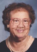

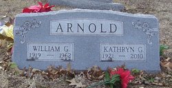
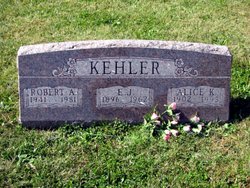
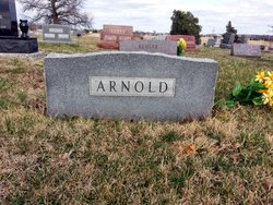
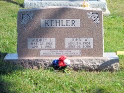
Kathryn G Kehler Arnold
| Birth | : | 29 Jun 1921 Brown County, Kansas, USA |
| Death | : | 24 Jul 2010 Holton, Jackson County, Kansas, USA |
| Burial | : | Abbey & St James' Graveyard for the Poor, Widcombe, Bath and North East Somerset Unitary Authority, England |
| Coordinate | : | 51.3753550, -2.3545640 |
| Plot | : | Section H |
| Description | : | Kathryn G. Arnold Weckman, 89, of Holton, KS passed away Saturday, July 24, 2010 at The Pines in Holton. She was born June 29, 1921 in Brown County, KS the daughter of Ellsworth and Alice Mesnard Kehler. She graduated from Holton High School in 1939 and lived in the Holton community all of her life. Kathryn was a farmwife and a longtime member of the Evangel United Methodist Church and the King's Daughters Sunday School Class. She also belonged to the Violet Club, Elk Valley Grange and the Jackson County Historical Society. Kathryn was married to William "Bill" Arnold on... Read More |
frequently asked questions (FAQ):
-
Where is Kathryn G Kehler Arnold's memorial?
Kathryn G Kehler Arnold's memorial is located at: Abbey & St James' Graveyard for the Poor, Widcombe, Bath and North East Somerset Unitary Authority, England.
-
When did Kathryn G Kehler Arnold death?
Kathryn G Kehler Arnold death on 24 Jul 2010 in Holton, Jackson County, Kansas, USA
-
Where are the coordinates of the Kathryn G Kehler Arnold's memorial?
Latitude: 51.3753550
Longitude: -2.3545640
Family Members:
Parent

Spouse

Siblings

Flowers:


Nearby Cemetories:
1. Abbey & St James' Graveyard for the Poor
Widcombe, Bath and North East Somerset Unitary Authority, England
Coordinate: 51.3753550, -2.3545640
2. Old Baptist Burial Ground
Walcot, Bath and North East Somerset Unitary Authority, England
Coordinate: 51.3755070, -2.3544360
3. Baptist Burial Ground
Widcombe, Bath and North East Somerset Unitary Authority, England
Coordinate: 51.3764216, -2.3556947
4. Saint Mark's Churchyard
Widcombe, Bath and North East Somerset Unitary Authority, England
Coordinate: 51.3766660, -2.3588010
5. Quaker Burial Ground
Widcombe, Bath and North East Somerset Unitary Authority, England
Coordinate: 51.3744350, -2.3498460
6. Unitarian Chapel Burial Ground
Widcombe, Bath and North East Somerset Unitary Authority, England
Coordinate: 51.3704650, -2.3539270
7. Old Orchard Street Catholic Burial Vault
Bath, Bath and North East Somerset Unitary Authority, England
Coordinate: 51.3800370, -2.3579910
8. St Thomas à Becket's Church
Widcombe, Bath and North East Somerset Unitary Authority, England
Coordinate: 51.3734250, -2.3465560
9. Bath Abbey Cemetery
Widcombe, Bath and North East Somerset Unitary Authority, England
Coordinate: 51.3712850, -2.3483060
10. St James Old Burial Ground
Bath, Bath and North East Somerset Unitary Authority, England
Coordinate: 51.3798600, -2.3610100
11. St Mary Magdalen Chapel
Widcombe, Bath and North East Somerset Unitary Authority, England
Coordinate: 51.3760486, -2.3643405
12. Bath Abbey
Bath, Bath and North East Somerset Unitary Authority, England
Coordinate: 51.3815310, -2.3586640
13. St John the Evangelist Cemetery
Bath, Bath and North East Somerset Unitary Authority, England
Coordinate: 51.3696700, -2.3487400
14. St. Mary de Stall Churchyard (Defunct)
Bath, Bath and North East Somerset Unitary Authority, England
Coordinate: 51.3813350, -2.3600353
15. Smallcombe Vale Cemetery
Bathwick, Bath and North East Somerset Unitary Authority, England
Coordinate: 51.3757400, -2.3429400
16. Quaker Meeting House
Bath, Bath and North East Somerset Unitary Authority, England
Coordinate: 51.3823280, -2.3604380
17. Bath General Hospital Burial Ground
Bath and North East Somerset Unitary Authority, England
Coordinate: 51.3824715, -2.3614742
18. St. Mary The Virgin Churchyard
Bathwick, Bath and North East Somerset Unitary Authority, England
Coordinate: 51.3759930, -2.3411930
19. Ss Michael & Paul Churchyard
Bath, Bath and North East Somerset Unitary Authority, England
Coordinate: 51.3834970, -2.3596980
20. St. Michael's Burial Ground
Bath, Bath and North East Somerset Unitary Authority, England
Coordinate: 51.3838810, -2.3594090
21. St Mary's Chapel, Queens Square
Bath, Bath and North East Somerset Unitary Authority, England
Coordinate: 51.3827790, -2.3649790
22. St. James' Cemetery
Bath, Bath and North East Somerset Unitary Authority, England
Coordinate: 51.3802000, -2.3722200
23. St. Mary's Churchyard
Bathwick, Bath and North East Somerset Unitary Authority, England
Coordinate: 51.3876120, -2.3543540
24. Prior Park College
Bath, Bath and North East Somerset Unitary Authority, England
Coordinate: 51.3645990, -2.3442400