
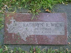
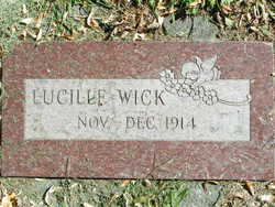
Kathryn “Katie” Beak Wick
| Birth | : | 27 Apr 1885 Corder, Lafayette County, Missouri, USA |
| Death | : | 8 Jul 1976 Brewster, Okanogan County, Washington, USA |
| Burial | : | Havelock Cemetery, Havelock, Marlborough District, New Zealand |
| Coordinate | : | -41.2826300, 173.7684800 |
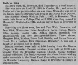
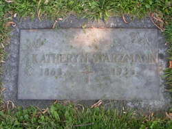
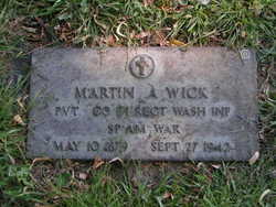
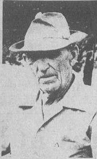
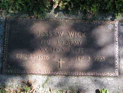
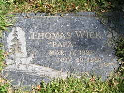
| Description | : | Adopted by her step father. m: 1 Feb 1905 in Okanogan Co, WA, listed as Starzman on certificate Kathryn Wick, 91, Brewster, died Thursday at a local hospital. She was born on April 27, 1885, in Corder, Mo., and came to Roslyn with her parents when she was three. When she was seven the family came to Brewster and lived in the North Star District. She married Martin Wick on Feb. 1, 1905, in Brewster. They made their home on College Flat until 1938 when they moved to Monse. Mr. Wick died in 1942, and she moved back to Brewster in 1955. Surviving are... Read More |
frequently asked questions (FAQ):
-
Where is Kathryn “Katie” Beak Wick's memorial?
Kathryn “Katie” Beak Wick's memorial is located at: Havelock Cemetery, Havelock, Marlborough District, New Zealand.
-
When did Kathryn “Katie” Beak Wick death?
Kathryn “Katie” Beak Wick death on 8 Jul 1976 in Brewster, Okanogan County, Washington, USA
-
Where are the coordinates of the Kathryn “Katie” Beak Wick's memorial?
Latitude: -41.2826300
Longitude: 173.7684800
Family Members:
Parent
Spouse
Siblings

Children
Flowers:


Nearby Cemetories:
1. Havelock Cemetery
Havelock, Marlborough District, New Zealand
Coordinate: -41.2826300, 173.7684800
2. Kaiuma Bay Graves
Kaiuma, Marlborough District, New Zealand
Coordinate: -41.2362962, 173.7875701
3. Ruapeka Cemetery
Canvastown, Marlborough District, New Zealand
Coordinate: -41.2883780, 173.6901440
4. Mahakipawa
Linkwater, Marlborough District, New Zealand
Coordinate: -41.2892290, 173.8474970
5. Te Horo Cemetery
Canvastown, Marlborough District, New Zealand
Coordinate: -41.2887942, 173.6652268
6. Deep Creek Cemetery
Deep Creek, Marlborough District, New Zealand
Coordinate: -41.3556480, 173.6320210
7. Rai Valley Cemetery
Rai Valley, Marlborough District, New Zealand
Coordinate: -41.2127080, 173.5802470
8. Picton Cemetery
Picton, Marlborough District, New Zealand
Coordinate: -41.2902300, 173.9976500
9. Picton Gaolyard
Picton, Marlborough District, New Zealand
Coordinate: -41.2933357, 174.0046601
10. Ruakanakana Urupā
Kaituna, Marlborough District, New Zealand
Coordinate: -41.4463616, 173.8779400
11. Maher Family Cemetery
Kaituna, Marlborough District, New Zealand
Coordinate: -41.4682494, 173.7958289
12. Kaituna Cemetery
Kaituna, Marlborough District, New Zealand
Coordinate: -41.4694650, 173.8036590
13. Wairau Affray Graves
Tuamarina, Marlborough District, New Zealand
Coordinate: -41.4285146, 173.9597007
14. Waikawa Urupā
Waikawa, Marlborough District, New Zealand
Coordinate: -41.2739670, 174.0411840
15. Tuamarina Cemetery
Tuamarina, Marlborough District, New Zealand
Coordinate: -41.4280969, 173.9623665
16. Rapaura Community Churchyard
Rapaura, Marlborough District, New Zealand
Coordinate: -41.4724800, 173.8995800
17. Rapaura Anglican Cemetery
Rapaura, Marlborough District, New Zealand
Coordinate: -41.4719700, 173.9014700
18. McLaren's Grave
Nelson City, New Zealand
Coordinate: -41.0722901, 173.6998022
19. Langley Dale Cemetery
Marlborough District, New Zealand
Coordinate: -41.5076952, 173.7025647
20. Pioneers Church Cemetery
Renwick, Marlborough District, New Zealand
Coordinate: -41.5091139, 173.8364765
21. Upper Wairau Valley Cemetery
Blenheim, Marlborough District, New Zealand
Coordinate: -41.5171130, 173.7974110
22. Old Renwick Cemetery
Marlborough District, New Zealand
Coordinate: -41.5014030, 173.8909900
23. Robin Hood Bay Urupā
Marlborough District, New Zealand
Coordinate: -41.3541665, 174.0768701
24. Māori Island Urupā Otamawahu
Grovetown, Marlborough District, New Zealand
Coordinate: -41.4729310, 173.9778908