
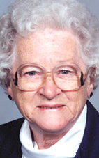

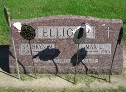
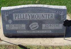
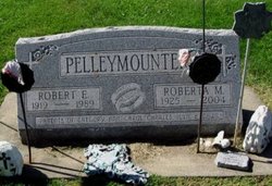
Kathryn “Kay” Pelleymounter Elliott
| Birth | : | 22 Jul 1920 Manly, Worth County, Iowa, USA |
| Death | : | 19 Jul 2009 Osage, Mitchell County, Iowa, USA |
| Burial | : | Sacred Heart Cemetery, Osage, Mitchell County, USA |
| Coordinate | : | 43.2742004, -92.7917023 |
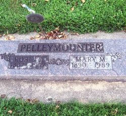
| Description | : | OSAGE, IOWA - Kathryn "Kay" Elliott, 88, of Osage, died on Sunday, July 19, 2009, at Faith Lutheran Home in Osage. She was born on July 22, 1920, near Manly, Iowa, the daughter of Robin and Mary (Popp) Pelleymounter. Kay graduated from Osage High School in 1939. She married Max L. Elliott on Nov. 27, 1941, in Pacific Beach, Calif. Kay worked in a defense plant in San Diego, Calif., during World War II. She also worked as a clerk at the Daylight Store in Osage, before starting her family. Kay was a member of Sacred Heart Church, the American... Read More |
frequently asked questions (FAQ):
-
Where is Kathryn “Kay” Pelleymounter Elliott's memorial?
Kathryn “Kay” Pelleymounter Elliott's memorial is located at: Sacred Heart Cemetery, Osage, Mitchell County, USA.
-
When did Kathryn “Kay” Pelleymounter Elliott death?
Kathryn “Kay” Pelleymounter Elliott death on 19 Jul 2009 in Osage, Mitchell County, Iowa, USA
-
Where are the coordinates of the Kathryn “Kay” Pelleymounter Elliott's memorial?
Latitude: 43.2742004
Longitude: -92.7917023
Family Members:
Parent

Spouse
Siblings

Children
Flowers:


Nearby Cemetories:
1. Sacred Heart Cemetery
Osage, Mitchell County, USA
Coordinate: 43.2742004, -92.7917023
2. South Osage Mennonite Church Cemetery
Osage, Mitchell County, USA
Coordinate: 43.2544556, -92.7915573
3. Osage Cemetery
Osage, Mitchell County, USA
Coordinate: 43.2916700, -92.8201700
4. Tucker Cemetery
Osage, Mitchell County, USA
Coordinate: 43.2494011, -92.8319016
5. Orchard Cemetery
Orchard, Mitchell County, USA
Coordinate: 43.2249985, -92.7838898
6. Calvary Cemetery
Osage, Mitchell County, USA
Coordinate: 43.2238998, -92.8300018
7. Oak Grove Cemetery
Mitchell, Mitchell County, USA
Coordinate: 43.3156013, -92.8707962
8. Dudley Cemetery
Dudley (historical), Mitchell County, USA
Coordinate: 43.2252998, -92.8743973
9. Rock Creek Cemetery
Meroa, Mitchell County, USA
Coordinate: 43.2352791, -92.9225006
10. Stillwater Cemetery
Orchard, Mitchell County, USA
Coordinate: 43.2130585, -92.6780624
11. Eden Presbyterian Cemetery
Meroa, Mitchell County, USA
Coordinate: 43.2131004, -92.9103012
12. Beaver Creek Cemetery
Brownville, Mitchell County, USA
Coordinate: 43.3397217, -92.6727829
13. Saint Peters Cemetery
New Haven, Mitchell County, USA
Coordinate: 43.2858315, -92.6427765
14. Howardville Cemetery
Floyd, Floyd County, USA
Coordinate: 43.1866989, -92.7016983
15. West End Cemetery
Meroa, Mitchell County, USA
Coordinate: 43.2216682, -92.9250031
16. Riverview Cemetery
Saint Ansgar, Mitchell County, USA
Coordinate: 43.3430328, -92.9220200
17. Liberty Cemetery
Little Cedar, Mitchell County, USA
Coordinate: 43.3856010, -92.7230988
18. Saint Ansgar Cemetery
Saint Ansgar, Mitchell County, USA
Coordinate: 43.3777809, -92.9094391
19. Immanuel Lutheran Cemetery
Saint Ansgar, Mitchell County, USA
Coordinate: 43.3717003, -92.9257965
20. First Lutheran Cemetery
Saint Ansgar, Mitchell County, USA
Coordinate: 43.3841705, -92.9194412
21. Blakestad Cemetery
Saint Ansgar, Mitchell County, USA
Coordinate: 43.3711014, -92.9400024
22. Saint Johns Lutheran Cemetery
Rock Creek, Mitchell County, USA
Coordinate: 43.3295560, -92.9849770
23. Saint Johns Lutheran Old Cemetery
Rock Creek, Mitchell County, USA
Coordinate: 43.3313904, -92.9897232
24. Stacyville Cemetery
Stacyville, Mitchell County, USA
Coordinate: 43.4294014, -92.7908020