
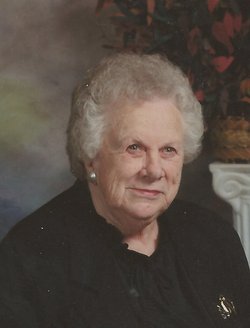
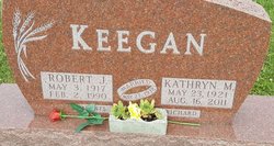
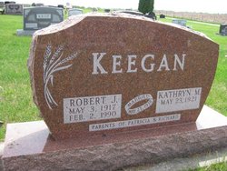
Kathryn M. Carroll Keegan
| Birth | : | 23 May 1921 Littleton, Buchanan County, Iowa, USA |
| Death | : | 16 Aug 2011 La Porte City, Black Hawk County, Iowa, USA |
| Burial | : | Westview Cemetery, La Porte City, Black Hawk County, USA |
| Coordinate | : | 42.3107986, -92.1699982 |
| Description | : | Daughter of Ted E. & Lydia L. Benson Carroll Kathryn M. Keegan, 90, of La Porte City, died Tuesday, August 16, 2011 at the La Porte City Nursing and Rehab Center of natural causes. She was born May 23, 1921 in Littleton; the daughter of Ted E. and Lydia L. Benson Carroll. She married Robert "Bob" Keegan on May 27, 1938 in Eagle Center; he preceded her in death on February 2, 1990. Survived by: one son, Richard (Connie) Keegan of La Porte City; one daughter, Patricia Allen of La Porte City; two sisters-in-law, Shirley Keegan of La Porte City, Clarice... Read More |
frequently asked questions (FAQ):
-
Where is Kathryn M. Carroll Keegan's memorial?
Kathryn M. Carroll Keegan's memorial is located at: Westview Cemetery, La Porte City, Black Hawk County, USA.
-
When did Kathryn M. Carroll Keegan death?
Kathryn M. Carroll Keegan death on 16 Aug 2011 in La Porte City, Black Hawk County, Iowa, USA
-
Where are the coordinates of the Kathryn M. Carroll Keegan's memorial?
Latitude: 42.3107986
Longitude: -92.1699982
Family Members:
Spouse
Children
Flowers:


Nearby Cemetories:
1. Westview Cemetery
La Porte City, Black Hawk County, USA
Coordinate: 42.3107986, -92.1699982
2. Sawyer Cemetery
La Porte City, Black Hawk County, USA
Coordinate: 42.3381004, -92.1519012
3. Engledow Cemetery
Mount Auburn, Benton County, USA
Coordinate: 42.2686996, -92.1330032
4. Anton Cemetery
La Porte City, Black Hawk County, USA
Coordinate: 42.3418999, -92.2399979
5. Mount Auburn Cemetery
Mount Auburn, Benton County, USA
Coordinate: 42.2536800, -92.0903000
6. Spring Creek Chapel Cemetery
La Porte City, Black Hawk County, USA
Coordinate: 42.3616982, -92.0783005
7. Zion Lutheran Jubilee Cemetery
Jubilee, Black Hawk County, USA
Coordinate: 42.3843050, -92.0837440
8. Greenwalt Cemetery
Mount Auburn, Benton County, USA
Coordinate: 42.2256012, -92.1038971
9. Fairview Cemetery
Benton County, USA
Coordinate: 42.2141991, -92.2007980
10. Pratt Creek Cemetery
Vinton, Benton County, USA
Coordinate: 42.2104000, -92.1307400
11. Sancta Maria Cemetery
Gilbertville, Black Hawk County, USA
Coordinate: 42.4132560, -92.2060940
12. Shady Grove Cemetery
Jesup, Buchanan County, USA
Coordinate: 42.3805453, -92.0557342
13. Saint Mary's Cemetery
Gilbertville, Black Hawk County, USA
Coordinate: 42.4188300, -92.2181200
14. Hill Cemetery
Tama County, USA
Coordinate: 42.2542000, -92.3075027
15. Saint Marys of Mount Carmel Cemetery
Waterloo, Black Hawk County, USA
Coordinate: 42.3418000, -92.3280000
16. Brown Bruce Township Cemetery
Benton County, USA
Coordinate: 42.2163430, -92.2799680
17. Washburn Cemetery
Washburn, Black Hawk County, USA
Coordinate: 42.4139200, -92.2711700
18. Brandon Cemetery
Brandon, Buchanan County, USA
Coordinate: 42.3156300, -91.9945200
19. Jefferson Township Cemetery
Brandon, Buchanan County, USA
Coordinate: 42.3139000, -91.9931030
20. Beachler Cemetery
Brandon, Buchanan County, USA
Coordinate: 42.3045000, -91.9908000
21. Spencer Cemetery
Dysart, Tama County, USA
Coordinate: 42.2592120, -92.3353840
22. Eagle Township Cemetery
Black Hawk County, USA
Coordinate: 42.3410988, -92.3525009
23. Geneseo Cemetery
Buckingham, Tama County, USA
Coordinate: 42.2764370, -92.3523950
24. Carlisle Grove Cemetery
Garrison, Benton County, USA
Coordinate: 42.1730995, -92.1386032