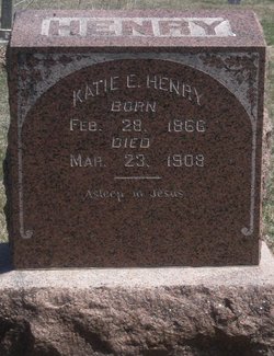
Katie Ellen Jones Henry
| Birth | : | 28 Feb 1866 Table Rock, Pawnee County, Nebraska, USA |
| Death | : | 23 Mar 1908 Topeka, Shawnee County, Kansas, USA |
| Burial | : | Mount Pleasant Cemetery, Courtland, Republic County, USA |
| Coordinate | : | 39.8319016, -97.8846970 |
| Description | : | Table Rock Argus, Table Rock,NE. Thursday, April 2, 1908. (Pg.5,col.1) Katie Ellen Jones was born February 28, 1866 at Table Rock, Nebraska where she lived with her parents until March 23rd, 1892 when she was married to Samuel J. Henry and came to Courtland to make her home. Four children were born to this union, three of whom survive her. Besides her husband, two sons, Elmer and Harold and one daughter Louise, she leaves a mother, three sisters and one brother to mourn her death which occurred at Topeka March 23rd, 1908. At the age of fifteen she united with the... Read More |
frequently asked questions (FAQ):
-
Where is Katie Ellen Jones Henry's memorial?
Katie Ellen Jones Henry's memorial is located at: Mount Pleasant Cemetery, Courtland, Republic County, USA.
-
When did Katie Ellen Jones Henry death?
Katie Ellen Jones Henry death on 23 Mar 1908 in Topeka, Shawnee County, Kansas, USA
-
Where are the coordinates of the Katie Ellen Jones Henry's memorial?
Latitude: 39.8319016
Longitude: -97.8846970
Family Members:
Flowers:
Nearby Cemetories:
1. Mount Pleasant Cemetery
Courtland, Republic County, USA
Coordinate: 39.8319016, -97.8846970
2. Persinger Cemetery
Courtland, Republic County, USA
Coordinate: 39.8605660, -97.9044880
3. Randall Memorial Cemetery
Courtland, Republic County, USA
Coordinate: 39.7992900, -97.8763900
4. Courtland Cemetery
Courtland, Republic County, USA
Coordinate: 39.7839012, -97.8768997
5. White Rock Cemetery
Republic, Republic County, USA
Coordinate: 39.8788986, -97.9132996
6. Laurel Hill Cemetery
Lovewell, Jewell County, USA
Coordinate: 39.8417015, -97.9608002
7. Fredie Hale Gravesite
Formoso, Jewell County, USA
Coordinate: 39.7945150, -97.9514200
8. Gritten Cemetery
Republic, Republic County, USA
Coordinate: 39.9006004, -97.8578033
9. Riverview Cemetery
Scandia, Republic County, USA
Coordinate: 39.8013992, -97.7881012
10. Balch Cemetery
Formoso, Jewell County, USA
Coordinate: 39.7983017, -97.9807968
11. Lutheran Cemetery
Scandia, Republic County, USA
Coordinate: 39.8125000, -97.7810974
12. Prairie Rose Cemetery
Republic, Republic County, USA
Coordinate: 39.8929700, -97.8010700
13. Switzers Gap Cemetery
Jewell County, USA
Coordinate: 39.8422012, -98.0255966
14. Fairview Cemetery
Lovewell, Jewell County, USA
Coordinate: 39.9073720, -97.9882780
15. Union Valley Cemetery
Scandia, Republic County, USA
Coordinate: 39.8599330, -97.7447500
16. Caldwell Cemetery
Jewell County, USA
Coordinate: 39.7266998, -97.9499969
17. Ada Lutheran Cemetery
Kackley, Republic County, USA
Coordinate: 39.7120000, -97.8670000
18. Poplar Grove Cemetery
Scandia, Republic County, USA
Coordinate: 39.7700005, -97.7347031
19. Rose Mound Cemetery
Big Bend Township, Republic County, USA
Coordinate: 39.9655991, -97.9132996
20. Delta Cemetery
Jewell County, USA
Coordinate: 39.7961006, -98.0556030
21. Dahl Cemetery
Webber, Jewell County, USA
Coordinate: 39.8993988, -98.0432968
22. Lake Cemetery
Republic, Republic County, USA
Coordinate: 39.9667015, -97.8380966
23. Webber Cemetery
Webber, Jewell County, USA
Coordinate: 39.9281040, -98.0354410
24. Pleasant View Cemetery
Montrose, Jewell County, USA
Coordinate: 39.7556000, -98.0539017


