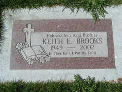
Keith Eugene Brooks
| Birth | : | 16 Sep 1949 Wenatchee, Chelan County, Washington, USA |
| Death | : | 24 May 2002 East Wenatchee, Douglas County, Washington, USA |
| Burial | : | Saint Stephens Cemetery, Bridgewater, McCook County, USA |
| Coordinate | : | 43.5574989, -97.4766998 |
| Description | : | Keith Eugene Brooks, 52, a lifelong resident of Wenatchee, went to be with the Lord on May 24, 2002. Keith grew up in the Wenatchee Valley and attended Eastmont Schools. He worked as a millworker 3and a truck driver for the Ardenvoir Mill. He blessed many lives in the Wenatchee area rest homes, singing gospel music and playing the guitar. He also played drums and sang in several churches throughout the Valley. He was dearly loved by everyone who met him. He became ill in January 2001 and still gave a helping hand to anyone who needed it. He chose not... Read More |
frequently asked questions (FAQ):
-
Where is Keith Eugene Brooks's memorial?
Keith Eugene Brooks's memorial is located at: Saint Stephens Cemetery, Bridgewater, McCook County, USA.
-
When did Keith Eugene Brooks death?
Keith Eugene Brooks death on 24 May 2002 in East Wenatchee, Douglas County, Washington, USA
-
Where are the coordinates of the Keith Eugene Brooks's memorial?
Latitude: 43.5574989
Longitude: -97.4766998
Family Members:
Parent
Flowers:
Nearby Cemetories:
1. Saint Stephens Cemetery
Bridgewater, McCook County, USA
Coordinate: 43.5574989, -97.4766998
2. Bridgewater Cemetery
Bridgewater, McCook County, USA
Coordinate: 43.5541600, -97.5059400
3. Pleasant Prairie Cemetery
Bridgewater, McCook County, USA
Coordinate: 43.5430984, -97.4496994
4. Rasmussen Cemetery
Bridgewater, McCook County, USA
Coordinate: 43.5283012, -97.5567017
5. Hofer Cemetery
Freeman, Hutchinson County, USA
Coordinate: 43.4726830, -97.5299150
6. Adrian Cemetery
Freeman, Hutchinson County, USA
Coordinate: 43.4730320, -97.4196550
7. Schrag Farm Cemetery
Bridgewater, McCook County, USA
Coordinate: 43.4760720, -97.5570940
8. Our Lady of Lourdes Catholic Cemetery
Dolton, Turner County, USA
Coordinate: 43.4871320, -97.3732960
9. Rose Hill Cemetery
McCook County, USA
Coordinate: 43.5119019, -97.3478012
10. Riverside Cemetery
Canistota, McCook County, USA
Coordinate: 43.5360985, -97.3283005
11. Kleinkassel Cemetery
Hutchinson County, USA
Coordinate: 43.4369011, -97.4997025
12. Neu Hutterthal Mennonite Cemetery
Hutchinson County, USA
Coordinate: 43.4510040, -97.5605320
13. Saint Martins Catholic Cemetery
Emery, Hanson County, USA
Coordinate: 43.6147003, -97.6271973
14. Emery Community Cemetery
Emery, Hanson County, USA
Coordinate: 43.5572014, -97.6474991
15. Salem Mennonite Brethren Church Cemetery
Hutchinson County, USA
Coordinate: 43.4440240, -97.5660950
16. Mennonite Cemetery
Dolton, Turner County, USA
Coordinate: 43.4472008, -97.3788986
17. New Hope Cemetery
Hanson County, USA
Coordinate: 43.5102997, -97.6457977
18. Anna Koerner Burial Site
Hutchinson County, USA
Coordinate: 43.4290258, -97.4196065
19. West Vermillion Cemetery
Marion, Turner County, USA
Coordinate: 43.4706001, -97.3189011
20. Dick Cemetery
Turner County, USA
Coordinate: 43.4528008, -97.3319016
21. Elfert Cemetery
Hanson County, USA
Coordinate: 43.5727997, -97.6868973
22. Hutterthal Mennonite Church Cemetery
Freeman, Hutchinson County, USA
Coordinate: 43.4041400, -97.4605000
23. Saint Peters Lutheran Cemetery
Clayton, Hutchinson County, USA
Coordinate: 43.4721985, -97.6557999
24. Canistota Cemetery
Canistota, McCook County, USA
Coordinate: 43.6035995, -97.2671967


