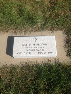
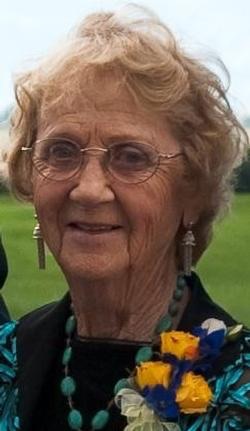
Keith M. “Brownie” Brown
| Birth | : | 10 May 1923 Salem, McCook County, South Dakota, USA |
| Death | : | 25 Dec 2014 Sturgis, Meade County, South Dakota, USA |
| Burial | : | Monroe Reformed Church Cemetery, McCook County, USA |
| Coordinate | : | 43.5004100, -97.2358170 |
| Description | : | Keith M. (Brownie) Brown, Spearfish, SD, formerly of Monroe, SD died Thursday, December 25 2014, at Ft Meade Hospice Unit in Sturgis, SD. Keith was born May 10, 1923 in Salem, SD where he lived until 1937. He and his family moved to Sioux Falls where he attended Washington High School. He joined the Navy following high school where he was attached to the Medical Corp. He served in the South Pacific in WWII. After his discharge he attended Nettleton College where he met his wife Virdella Chilson. They were married in 1946. Keith worked for Kreisers starting from pharmacy... Read More |
frequently asked questions (FAQ):
-
Where is Keith M. “Brownie” Brown's memorial?
Keith M. “Brownie” Brown's memorial is located at: Monroe Reformed Church Cemetery, McCook County, USA.
-
When did Keith M. “Brownie” Brown death?
Keith M. “Brownie” Brown death on 25 Dec 2014 in Sturgis, Meade County, South Dakota, USA
-
Where are the coordinates of the Keith M. “Brownie” Brown's memorial?
Latitude: 43.5004100
Longitude: -97.2358170
Family Members:
Parent
Spouse
Siblings
Flowers:
Nearby Cemetories:
1. Monroe Reformed Church Cemetery
McCook County, USA
Coordinate: 43.5004100, -97.2358170
2. Spring Valley Baptist Cemetery
Spring Valley Township, McCook County, USA
Coordinate: 43.5325920, -97.2290730
3. First Church of God Cemetery
Marion, Turner County, USA
Coordinate: 43.4447000, -97.2727000
4. Saint Marys Catholic Cemetery
Marion, Turner County, USA
Coordinate: 43.4371986, -97.2596970
5. West Vermillion Cemetery
Marion, Turner County, USA
Coordinate: 43.4706001, -97.3189011
6. Riverside Cemetery
Canistota, McCook County, USA
Coordinate: 43.5360985, -97.3283005
7. Rose Hill Cemetery
McCook County, USA
Coordinate: 43.5119019, -97.3478012
8. Dick Cemetery
Turner County, USA
Coordinate: 43.4528008, -97.3319016
9. Greenwood Cemetery
Marion, Turner County, USA
Coordinate: 43.4150009, -97.2493973
10. Buller-Ensz Cemetery
Turner County, USA
Coordinate: 43.4186000, -97.2828500
11. Our Lady of Lourdes Catholic Cemetery
Dolton, Turner County, USA
Coordinate: 43.4871320, -97.3732960
12. Saint Joseph Wellington Cemetery
Humboldt, Minnehaha County, USA
Coordinate: 43.5577600, -97.1171400
13. Wellington Cemetery
Turner County, USA
Coordinate: 43.4994011, -97.0922012
14. Canistota Cemetery
Canistota, McCook County, USA
Coordinate: 43.6035995, -97.2671967
15. Tieszen Cemetery
Marion, Turner County, USA
Coordinate: 43.4219017, -97.3388977
16. Rosehill Cemetery
Parker, Turner County, USA
Coordinate: 43.4117012, -97.1399994
17. Mennonite Cemetery
Dolton, Turner County, USA
Coordinate: 43.4472008, -97.3788986
18. German Methodist
Humboldt, Minnehaha County, USA
Coordinate: 43.5073050, -97.0691760
19. Saint Christina Cemetery
Parker, Turner County, USA
Coordinate: 43.3903008, -97.1502991
20. Adrian Cemetery
Freeman, Hutchinson County, USA
Coordinate: 43.4730320, -97.4196550
21. Anna Koerner Burial Site
Hutchinson County, USA
Coordinate: 43.4290258, -97.4196065
22. Pleasant Prairie Cemetery
Bridgewater, McCook County, USA
Coordinate: 43.5430984, -97.4496994
23. Salem Zion Mennonite Cemetery
Turner County, USA
Coordinate: 43.3507996, -97.3296967
24. Turkey Valley Cemetery
Parker, Turner County, USA
Coordinate: 43.3280600, -97.2505500


