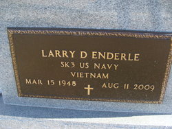
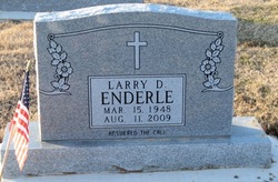
Larry Dale Enderle
| Birth | : | 15 Mar 1948 Cape Girardeau County, Missouri, USA |
| Death | : | 11 Aug 2009 Cape Girardeau County, Missouri, USA |
| Burial | : | Blanchester IOOF Cemetery, Blanchester, Clinton County, USA |
| Coordinate | : | 39.2921982, -83.9957962 |
| Inscription | : | ANSWERED THE CALL |
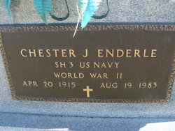
| Description | : | Larry Enderle KELSO, Mo. -- Larry Dale Enderle, 61, of Kelso died Tuesday, Aug. 11, 2009, at Saint Francis Medical Center in Cape Girardeau. He was born March 15, 1948, in Cape Girardeau to Chester James and Olga Meta Schroeder Enderle. Enderle served in the U.S. Navy during the Vietnam War and also served in the U.S. Naval Reserve 20 years. He was a food broker with Bene and Patterson and also worked at Bob's Foodliner in Scott City. He was a member of St. Augustine Catholic Church, Knights of Columbus Council 6420, life member of VFW Post 6407 in Scott City, Eagles Aerie... Read More |
frequently asked questions (FAQ):
-
Where is Larry Dale Enderle's memorial?
Larry Dale Enderle's memorial is located at: Blanchester IOOF Cemetery, Blanchester, Clinton County, USA.
-
When did Larry Dale Enderle death?
Larry Dale Enderle death on 11 Aug 2009 in Cape Girardeau County, Missouri, USA
-
Where are the coordinates of the Larry Dale Enderle's memorial?
Latitude: 39.2921982
Longitude: -83.9957962
Family Members:
Parent
Siblings
Flowers:
Nearby Cemetories:
1. Blanchester IOOF Cemetery
Blanchester, Clinton County, USA
Coordinate: 39.2921982, -83.9957962
2. West Mary Cemetery
Harlan Township, Warren County, USA
Coordinate: 39.3008003, -84.0152969
3. New Hope Cemetery
Harlan Township, Warren County, USA
Coordinate: 39.3088989, -84.0239029
4. Garrison Cemetery
Blanchester, Clinton County, USA
Coordinate: 39.2703018, -83.9681015
5. Osborne Cemetery
Harlan Township, Warren County, USA
Coordinate: 39.3224983, -84.0038986
6. Wesley Chapel Cemetery
Pleasant Plain, Warren County, USA
Coordinate: 39.2778015, -84.0355988
7. West Woodville Cemetery
Warren County, USA
Coordinate: 39.2561660, -84.0114110
8. Second Creek Cemetery
Blanchester, Clinton County, USA
Coordinate: 39.3164800, -83.9551600
9. Rossella Cemetery
Pleasant Plain, Warren County, USA
Coordinate: 39.3244019, -84.0421982
10. Edwardsville Cemetery
Edwardsville, Warren County, USA
Coordinate: 39.3333780, -84.0342390
11. Pleasant Grove Cemetery
Warren County, USA
Coordinate: 39.3400610, -84.0185430
12. Templin Cemetery
Pleasant Plain, Warren County, USA
Coordinate: 39.3107986, -84.0622025
13. Westboro IOOF Cemetery
Westboro, Clinton County, USA
Coordinate: 39.2845700, -83.9042900
14. Runyan Cemetery
Butlerville, Warren County, USA
Coordinate: 39.3013992, -84.0883026
15. Westboro Friends Cemetery
Westboro, Clinton County, USA
Coordinate: 39.2849998, -83.9013977
16. Jefferson Township Unidentified Cemetery #1
Jefferson Township, Clinton County, USA
Coordinate: 39.3143720, -83.9028310
17. Rehobath Cemetery
Blanchester, Clinton County, USA
Coordinate: 39.3512000, -83.9292000
18. Spurling Cemetery
Pleasant Plain, Warren County, USA
Coordinate: 39.2724991, -84.0952988
19. Howard Cemetery
Pleasant Plain, Warren County, USA
Coordinate: 39.3316994, -84.0886002
20. Engle Cemetery
Perry Township, Brown County, USA
Coordinate: 39.2155991, -83.9569016
21. Jordan Cemetery
Edenton, Clermont County, USA
Coordinate: 39.2254180, -84.0587770
22. Carson Cemetery
Pleasant Plain, Warren County, USA
Coordinate: 39.2914505, -84.1027145
23. Crosson Cemetery
Butlerville, Warren County, USA
Coordinate: 39.3058900, -84.1054900
24. Edenton Cemetery
Edenton, Clermont County, USA
Coordinate: 39.2216988, -84.0639038


