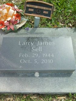
Larry James Sell
| Birth | : | 29 Feb 1944 Muscatine, Muscatine County, Iowa, USA |
| Death | : | 5 Oct 2010 Tipton, Cedar County, Iowa, USA |
| Burial | : | Mellen Union Cemetery, Mellen, Ashland County, USA |
| Coordinate | : | 46.3294800, -90.6621800 |
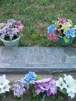
| Description | : | Tipton Conservative 20 Oct 2010 Graveside memorial services for Larry James Sell, 66, Tipton, will be held at 2 p.m. Saturday, Oct. 23, 2010 at the Rochester cemetery. Mr. Sell died Oct. 5 in his home. The son of Ralph and Naomi Mary Unruh Sell, he was born Feb. 29, 1944 in Muscatine. He graduated from Olin high school in 1962. Mr. Sell was a retired truck driver and machinist. He is survived by his aunts, uncles and cousins. He was preceded in death by his parents. |
frequently asked questions (FAQ):
-
Where is Larry James Sell's memorial?
Larry James Sell's memorial is located at: Mellen Union Cemetery, Mellen, Ashland County, USA.
-
When did Larry James Sell death?
Larry James Sell death on 5 Oct 2010 in Tipton, Cedar County, Iowa, USA
-
Where are the coordinates of the Larry James Sell's memorial?
Latitude: 46.3294800
Longitude: -90.6621800
Family Members:
Parent
Flowers:
Nearby Cemetories:
1. Mellen Union Cemetery
Mellen, Ashland County, USA
Coordinate: 46.3294800, -90.6621800
2. Mount Hope Cemetery
High Bridge, Ashland County, USA
Coordinate: 46.3859700, -90.7353300
3. Cayuga Union Cemetery
Cayuga, Ashland County, USA
Coordinate: 46.2522011, -90.6802979
4. Saint Johns Lutheran Cemetery
Mellen, Ashland County, USA
Coordinate: 46.3923800, -90.5690100
5. Greenwood Cemetery
Morse, Ashland County, USA
Coordinate: 46.2224846, -90.6509399
6. Maple Grove Cemetery
Marengo, Ashland County, USA
Coordinate: 46.3852997, -90.8606033
7. Old Apostolic Lutheran Cemetery
Marengo, Ashland County, USA
Coordinate: 46.4408640, -90.8473530
8. Greenwood Cemetery
Upson, Iron County, USA
Coordinate: 46.3778000, -90.4094009
9. Calvary Cemetery
Upson, Iron County, USA
Coordinate: 46.3774986, -90.4080963
10. Saint Anne Catholic Cemetery
Sanborn, Ashland County, USA
Coordinate: 46.4294281, -90.9071426
11. Mount Hope Cemetery
Glidden, Ashland County, USA
Coordinate: 46.1431800, -90.5717200
12. Edgewood Cemetery
Gurney, Iron County, USA
Coordinate: 46.4972000, -90.5077972
13. Most Precious Blood Cemetery
Glidden, Ashland County, USA
Coordinate: 46.1395226, -90.5726700
14. Moe Cemetery
Mason, Bayfield County, USA
Coordinate: 46.3789200, -90.9498900
15. Birch Lake Cemetery
Mason, Bayfield County, USA
Coordinate: 46.3569603, -90.9666595
16. Clam Lake Cemetery
Clam Lake, Ashland County, USA
Coordinate: 46.1664009, -90.9058990
17. Hillside Cemetery
Iron Belt, Iron County, USA
Coordinate: 46.4000015, -90.3377991
18. Lake View Cemetery
Saxon, Iron County, USA
Coordinate: 46.5010986, -90.4227982
19. Moland Lutheran Church Cemetery
Mason, Bayfield County, USA
Coordinate: 46.4131012, -90.9897995
20. Bad River Cemetery
Odanah, Ashland County, USA
Coordinate: 46.5992100, -90.7208900
21. Mount Hope Cemetery
Ashland, Ashland County, USA
Coordinate: 46.5621986, -90.9039001
22. Saint Agnes Cemetery
Ashland, Ashland County, USA
Coordinate: 46.5614014, -90.9075012
23. B'Nai Israel Cemetery
Ashland, Ashland County, USA
Coordinate: 46.5600014, -90.9116974
24. Mason Cemetery
Mason, Bayfield County, USA
Coordinate: 46.4401800, -91.0555800


