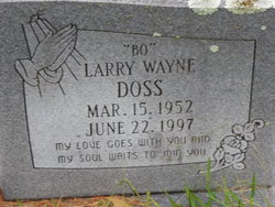
Larry Wayne “Bo” Doss
| Birth | : | 15 Mar 1952 Rison, Cleveland County, Arkansas, USA |
| Death | : | 22 Jun 1997 Pine Bluff, Jefferson County, Arkansas, USA |
| Burial | : | Mount Zion Cemetery, Rison, Cleveland County, USA |
| Coordinate | : | 34.0281556, -92.1148653 |
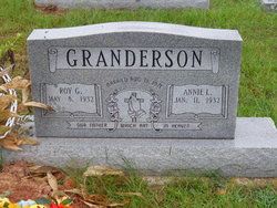
| Description | : | Larry "Bo" Doss, 45, of 50 Friendship Cemetery Road, Woodlawn Community, Cleveland County, died Sunday, June 22, 1997 at JRMC, in Pine Bluff, Arkansas. Born at Rison on March 15, 1952, he was a son of Annie Broach Doss Granderson and the late S. P. Doss, Jr. He was reared and educated in Pine Bluff, Arkansas, and graduated from Watson Chapel High School in 1971. He was a mechanic for the Pine Bluff Street Department. He was a Baptist. Survivors include his wife, Carolyn Burris Doss, in which he married on November 23, 1995 at... Read More |
frequently asked questions (FAQ):
-
Where is Larry Wayne “Bo” Doss's memorial?
Larry Wayne “Bo” Doss's memorial is located at: Mount Zion Cemetery, Rison, Cleveland County, USA.
-
When did Larry Wayne “Bo” Doss death?
Larry Wayne “Bo” Doss death on 22 Jun 1997 in Pine Bluff, Jefferson County, Arkansas, USA
-
Where are the coordinates of the Larry Wayne “Bo” Doss's memorial?
Latitude: 34.0281556
Longitude: -92.1148653
Family Members:
Parent
Siblings
Flowers:
Nearby Cemetories:
1. Mount Zion Cemetery
Rison, Cleveland County, USA
Coordinate: 34.0281556, -92.1148653
2. Harris Cemetery
Kedron, Cleveland County, USA
Coordinate: 34.0202510, -92.1141940
3. Bethlehem Cemetery
Rison, Cleveland County, USA
Coordinate: 33.9874510, -92.1180710
4. Niven - Watt Cemetery
Cleveland County, USA
Coordinate: 34.0209370, -92.1636200
5. Culpepper Cemetery
Kedron, Cleveland County, USA
Coordinate: 34.0537260, -92.1594140
6. Pleasant Ridge Cemetery
Rison, Cleveland County, USA
Coordinate: 34.0361670, -92.0499050
7. Mount Gillard Cemetery
Cleveland County, USA
Coordinate: 34.0107650, -92.0421610
8. Mount Zion Baptist Church Cemetery
Faith, Jefferson County, USA
Coordinate: 34.0858110, -92.0818130
9. Wesley Chapel Cemetery
Cleveland County, USA
Coordinate: 34.0031610, -92.0409960
10. Brown Cemetery
Jefferson County, USA
Coordinate: 34.0952988, -92.1050034
11. Union Hill Missionary Baptist Church Cemetery
Cleveland County, USA
Coordinate: 33.9839940, -92.1767140
12. Mount Carmel Cemetery
Cleveland County, USA
Coordinate: 34.0554540, -92.1918350
13. Blackwell Hill Cemetery
Jefferson County, USA
Coordinate: 34.0960999, -92.0718994
14. Hudson Family Cemetery
Jefferson County, USA
Coordinate: 34.0618640, -92.1983810
15. Rutledge Cemetery
Cleveland County, USA
Coordinate: 33.9625830, -92.1672250
16. Piney Grove Cemetery
Jefferson County, USA
Coordinate: 34.1002998, -92.1557999
17. Curl Cemetery
Jefferson County, USA
Coordinate: 34.1102982, -92.1035995
18. Randolph Cemetery
Rison, Cleveland County, USA
Coordinate: 34.0400009, -92.2161026
19. Friendship Cemetery
Friendship, Cleveland County, USA
Coordinate: 33.9818993, -92.0291977
20. John T Niven Cemetery
Rison, Cleveland County, USA
Coordinate: 33.9645050, -92.1960640
21. Roselawn Memorial Garden
Pine Bluff, Jefferson County, USA
Coordinate: 34.0825005, -92.0224991
22. Moores Church Cemetery
Rison, Cleveland County, USA
Coordinate: 33.9844017, -92.2164001
23. New Hope Cemetery
Rison, Cleveland County, USA
Coordinate: 33.9313850, -92.0950780
24. New Hope Original Cemetery
Cleveland County, USA
Coordinate: 33.9293400, -92.0942310

