
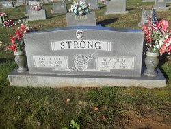
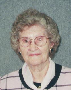
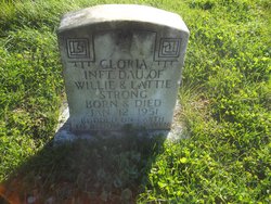
Lattie Lee Perrin Strong
| Birth | : | 12 Jan 1927 Moss, Clay County, Tennessee, USA |
| Death | : | 14 Jan 2003 Nashville, Davidson County, Tennessee, USA |
| Burial | : | Poplar Grove United Methodist Church Cemetery, Phoenix, Baltimore County, USA |
| Coordinate | : | 39.4975200, -76.6097900 |
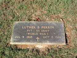
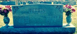
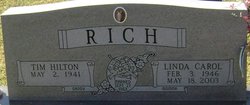
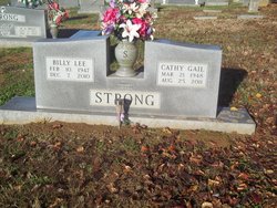
| Description | : | Lattie Lee Strong, 76, Celina, Tenn., died Jan. 14, 2003, at the St. Thomas Hospital in Nashville, Tenn. She was a member of the Church of Christ. Born in Moss, Tenn. on Jan. 12, 1927, she was a daughter of the late Luther B. and Florida Beatrice (Harp) Perrin and the wife of Willie A. Strong, who survives. Other than her husband, survivors include a son, Billy Lee "Butch" Strong, Celina, Tenn.; three daughters, Linda Rich, Celina, and Joyce Halsell and Martha Green, both of Lebanon, Tenn.; three brothers — Lell D. Perrin, Elwood, Ind.; Lex Perrin,... Read More |
frequently asked questions (FAQ):
-
Where is Lattie Lee Perrin Strong's memorial?
Lattie Lee Perrin Strong's memorial is located at: Poplar Grove United Methodist Church Cemetery, Phoenix, Baltimore County, USA.
-
When did Lattie Lee Perrin Strong death?
Lattie Lee Perrin Strong death on 14 Jan 2003 in Nashville, Davidson County, Tennessee, USA
-
Where are the coordinates of the Lattie Lee Perrin Strong's memorial?
Latitude: 39.4975200
Longitude: -76.6097900
Family Members:
Parent
Spouse
Siblings

Children
Flowers:


Nearby Cemetories:
1. Poplar Grove United Methodist Church Cemetery
Phoenix, Baltimore County, USA
Coordinate: 39.4975200, -76.6097900
2. Bazil African Methodist Episcopal Church Cemetery
Cockeysville, Baltimore County, USA
Coordinate: 39.4828000, -76.6293600
3. Ashland Presbyterian Church Cemetery
Cockeysville, Baltimore County, USA
Coordinate: 39.4940800, -76.6430400
4. Jessops United Methodist Church Cemetery
Sparks, Baltimore County, USA
Coordinate: 39.5078011, -76.6408005
5. Merryman Family Cemetery
Loch Raven, Baltimore County, USA
Coordinate: 39.4760000, -76.5880000
6. Ridgely and Talbott Family Cemetery
Baltimore County, USA
Coordinate: 39.4701960, -76.6116200
7. Old Gunpowder Friends' Burying Ground
Cockeysville, Baltimore County, USA
Coordinate: 39.4824917, -76.6426611
8. Sherwood Episcopal Church Cemetery
Cockeysville, Baltimore County, USA
Coordinate: 39.4828600, -76.6438100
9. Fairview United Methodist Church Cemetery
Phoenix, Baltimore County, USA
Coordinate: 39.5070100, -76.5685600
10. Hunt Valley Towne Center
Hunt Valley, Baltimore County, USA
Coordinate: 39.4986763, -76.6553421
11. Nisbet Cemetery
Cockeysville, Baltimore County, USA
Coordinate: 39.4627160, -76.6282660
12. Almshouse Cemetery
Cockeysville, Baltimore County, USA
Coordinate: 39.4596200, -76.6278900
13. Dulaney Valley Memorial Gardens
Timonium, Baltimore County, USA
Coordinate: 39.4562300, -76.6160700
14. Saint Joseph Cemetery
Cockeysville, Baltimore County, USA
Coordinate: 39.4622700, -76.6388100
15. Cockey Family Cemetery
Cockeysville, Baltimore County, USA
Coordinate: 39.4635010, -76.6426010
16. Long Crandon Cemetery
Timonium, Baltimore County, USA
Coordinate: 39.4532980, -76.5967770
17. Stevenson AME Church Cemetery
Sparks, Baltimore County, USA
Coordinate: 39.5296670, -76.6518610
18. Chestnut Grove Annex Cemetery
Jacksonville, Baltimore County, USA
Coordinate: 39.5215200, -76.5593000
19. Chestnut Grove Presbyterian Church Cemetery
Phoenix, Baltimore County, USA
Coordinate: 39.5129600, -76.5501500
20. Clynmalira United Methodist Church Cemetery
Monkton, Baltimore County, USA
Coordinate: 39.5379300, -76.5734700
21. Saint Johns Lutheran Church Cemetery of Blenheim
Blenheim, Baltimore County, USA
Coordinate: 39.4853300, -76.5419800
22. Saint John's Lutheran Church Cemetery
Sweet Air, Baltimore County, USA
Coordinate: 39.5126300, -76.5418200
23. Peerce Cemetery
Phoenix, Baltimore County, USA
Coordinate: 39.4706497, -76.5447159
24. Price Family Cemetery
Oregon, Baltimore County, USA
Coordinate: 39.4968583, -76.6840278