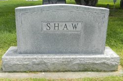
Laura B. Shaw Carson
| Birth | : | 1903 Lexington, Dawson County, Nebraska, USA |
| Death | : | 1980 Omaha, Douglas County, Nebraska, USA |
| Burial | : | Green Mount Cemetery, Dansville, Livingston County, USA |
| Coordinate | : | 42.5430984, -77.6813965 |
| Plot | : | DIV. D, BLOCK 15, LOT 4, SPACE 4. |
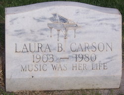
| Inscription | : | LAURA B CARSON 1903 - 1980 MUSIC WAS HER LIFE |
frequently asked questions (FAQ):
-
Where is Laura B. Shaw Carson's memorial?
Laura B. Shaw Carson's memorial is located at: Green Mount Cemetery, Dansville, Livingston County, USA.
-
When did Laura B. Shaw Carson death?
Laura B. Shaw Carson death on 1980 in Omaha, Douglas County, Nebraska, USA
-
Where are the coordinates of the Laura B. Shaw Carson's memorial?
Latitude: 42.5430984
Longitude: -77.6813965
Family Members:
Parent
Spouse
Siblings
Flowers:
Nearby Cemetories:
1. Green Mount Cemetery
Dansville, Livingston County, USA
Coordinate: 42.5430984, -77.6813965
2. Holy Cross Cemetery
Dansville, Livingston County, USA
Coordinate: 42.5433006, -77.6769028
3. Old Dansville Village Cemetery
Dansville, Livingston County, USA
Coordinate: 42.5570950, -77.6942610
4. Greenlawn Cemetery
Dansville, Steuben County, USA
Coordinate: 42.5197400, -77.6716800
5. Kidd - Fronk Cemetery
Dansville, Livingston County, USA
Coordinate: 42.5730553, -77.6724854
6. Sacred Heart Cemetery
Perkinsville, Steuben County, USA
Coordinate: 42.5411800, -77.6266930
7. Bluff Point Cemetery
Dansville, Steuben County, USA
Coordinate: 42.5044360, -77.6989940
8. Saint Peter's Cemetery
Perkinsville, Steuben County, USA
Coordinate: 42.5285988, -77.6256027
9. Woodsville Cemetery
West Sparta, Livingston County, USA
Coordinate: 42.5719833, -77.7329025
10. Sandy Hill Church Cemetery
Perkinsville, Steuben County, USA
Coordinate: 42.5093500, -77.6317100
11. Wood Cemetery
Ossian, Livingston County, USA
Coordinate: 42.5341988, -77.7506027
12. Old Saint Joseph's Cemetery
Wayland, Steuben County, USA
Coordinate: 42.5594800, -77.6075600
13. Reeds Corners Cemetery
Sparta, Livingston County, USA
Coordinate: 42.6001053, -77.6808090
14. Reed Cemetery
Sparta, Livingston County, USA
Coordinate: 42.6001663, -77.6826096
15. Pleasant Valley West Cemetery
Livingston County, USA
Coordinate: 42.5911789, -77.6376953
16. South Sparta Cemetery
Livingston County, USA
Coordinate: 42.5956001, -77.7193985
17. Poag's Hole Cemetery
South Dansville, Steuben County, USA
Coordinate: 42.4946310, -77.7287860
18. Saint Joseph's Cemetery
Wayland, Steuben County, USA
Coordinate: 42.5625200, -77.6044980
19. Old Cemetery
Wayland, Steuben County, USA
Coordinate: 42.5671330, -77.5946220
20. Ossian Center Cemetery
Ossian, Livingston County, USA
Coordinate: 42.5256004, -77.7731018
21. Rogersville Forest Lawn Cemetery
Dansville, Steuben County, USA
Coordinate: 42.4735985, -77.6605988
22. North Oak Hill Cemetery
South Dansville, Steuben County, USA
Coordinate: 42.4703200, -77.6832500
23. Wayland Village Cemetery
Wayland, Steuben County, USA
Coordinate: 42.5723280, -77.5901780
24. Dutch Cemetery
Livingston County, USA
Coordinate: 42.6183014, -77.6830978

