
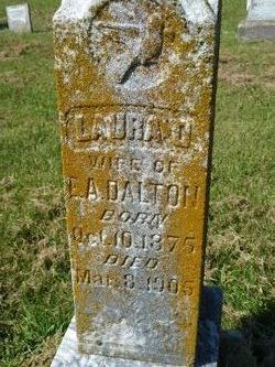
Laura D. Ramsey Dalton
| Birth | : | 10 Oct 1875 Berea, Madison County, Kentucky, USA |
| Death | : | 8 Mar 1905 Cantwell, St. Francois County, Missouri, USA |
| Burial | : | Spears Chapel Cemetery, Peytonsburg, Cumberland County, USA |
| Coordinate | : | 36.6495790, -85.3714410 |
| Description | : | Laura is one of the nine children of Robert George Ramsey and Harriett Jane Holcomb. Mr. Ramsey served as Justice of the Peace in Flat River, Missouri for many years. She married Edward Almo Dalton (my grandfather) on 23 Oct 1900 in Berea, Kentucky. Her younger brother, John Millard Ramsey, married Ed Dalton's youngest sister, Arlena Charlotte Dalton. Laura died of "milk leg fever" after the birth of their child, Earl "Jack E." Dalton. |
frequently asked questions (FAQ):
-
Where is Laura D. Ramsey Dalton's memorial?
Laura D. Ramsey Dalton's memorial is located at: Spears Chapel Cemetery, Peytonsburg, Cumberland County, USA.
-
When did Laura D. Ramsey Dalton death?
Laura D. Ramsey Dalton death on 8 Mar 1905 in Cantwell, St. Francois County, Missouri, USA
-
Where are the coordinates of the Laura D. Ramsey Dalton's memorial?
Latitude: 36.6495790
Longitude: -85.3714410
Family Members:


Nearby Cemetories:
1. Spears Chapel Cemetery
Peytonsburg, Cumberland County, USA
Coordinate: 36.6495790, -85.3714410
2. Peyton Spear Cemetery
Peytonsburg, Cumberland County, USA
Coordinate: 36.6481590, -85.3778400
3. Riley Cemetery
Littrell, Cumberland County, USA
Coordinate: 36.6509768, -85.3853975
4. Pruitt Cemetery
Peytonsburg, Cumberland County, USA
Coordinate: 36.6571270, -85.3874590
5. Groce Cemetery
Cumberland County, USA
Coordinate: 36.6546310, -85.3496130
6. Long Cemetery #1
Peytonsburg, Cumberland County, USA
Coordinate: 36.6380997, -85.3522034
7. Coop-Jennings Cemetery
Cumberland County, USA
Coordinate: 36.6693330, -85.3690650
8. Dulworth Cemetery
Cumberland County, USA
Coordinate: 36.6292100, -85.3757900
9. Lester and Winnie Spears Cemetery
Burkesville, Cumberland County, USA
Coordinate: 36.6304420, -85.3829600
10. Poplar Grove Cemetery
Kettle, Cumberland County, USA
Coordinate: 36.6680090, -85.4074180
11. Capps-Key Cemetery
Burkesville, Cumberland County, USA
Coordinate: 36.6605280, -85.4129330
12. Smith Cemetery
Monroe County, USA
Coordinate: 36.6439881, -85.4203414
13. Christian Chapel Cemetery
Peytonsburg, Cumberland County, USA
Coordinate: 36.6892330, -85.3599200
14. Clark Cemetery
Cumberland County, USA
Coordinate: 36.6916667, -85.3550000
15. Killman Cemetery
Ashlock, Cumberland County, USA
Coordinate: 36.6325850, -85.4256430
16. Williams Cemetery
Pea Ridge, Clay County, USA
Coordinate: 36.6150017, -85.4169006
17. Webb Cemetery
Kettle, Cumberland County, USA
Coordinate: 36.7027530, -85.3698160
18. Rock Springs Cemetery
Celina, Clay County, USA
Coordinate: 36.6096992, -85.4167023
19. Ashlock Cemetery
Ashlock, Cumberland County, USA
Coordinate: 36.6208380, -85.4283620
20. Thompson Webb Cemetery
Celina, Clay County, USA
Coordinate: 36.6090110, -85.4202270
21. Crossroads Cemetery
Clay County, USA
Coordinate: 36.6074982, -85.4210968
22. Chestnut Grove Cemetery
Burkesville, Cumberland County, USA
Coordinate: 36.6675800, -85.3008600
23. Spears Cemetery
Frogue, Cumberland County, USA
Coordinate: 36.6679800, -85.3002300
24. Hattie's Houses Cemetery
Pea Ridge, Clay County, USA
Coordinate: 36.6159200, -85.4360040