
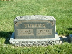
Laura I. Vogle Turner
| Birth | : | 3 Oct 1869 Kansas, USA |
| Death | : | 7 Mar 1947 Ellensburg, Kittitas County, Washington, USA |
| Burial | : | Hope Lutheran Cemetery, Delmont, Douglas County, USA |
| Coordinate | : | 43.2821999, -98.1568985 |
| Description | : | OBIT: Mrs. Laura Turner, 77, widely-known pioneer, a resident of the Kittitas Valley since 1882, died in a local hospital today. She had been ill for several weeks. Born in Kansas on October 13, 1869, Mrs. Turner came here as a child of 13 when Mr. and Mrs. John W. Haworth moved into the valley. She was raised by the Haworth's and married Frank L. Turner on October 13, 1887. Her husband and two children preceded her in death. She is survived by three grandchildren, Frank, John, and Sarah Jane Turner, all of Ellensburg. Interment will be at the Thorp Cemetery.... Read More |
frequently asked questions (FAQ):
-
Where is Laura I. Vogle Turner's memorial?
Laura I. Vogle Turner's memorial is located at: Hope Lutheran Cemetery, Delmont, Douglas County, USA.
-
When did Laura I. Vogle Turner death?
Laura I. Vogle Turner death on 7 Mar 1947 in Ellensburg, Kittitas County, Washington, USA
-
Where are the coordinates of the Laura I. Vogle Turner's memorial?
Latitude: 43.2821999
Longitude: -98.1568985
Family Members:
Parent
Spouse

Siblings
Children
Flowers:


Nearby Cemetories:
1. Hope Lutheran Cemetery
Delmont, Douglas County, USA
Coordinate: 43.2821999, -98.1568985
2. Zion Lutheran Cemetery
Delmont, Douglas County, USA
Coordinate: 43.2822000, -98.1558000
3. Delmont Cemetery
Delmont, Douglas County, USA
Coordinate: 43.2757988, -98.1481018
4. Old Missouri Cemetery
Delmont, Douglas County, USA
Coordinate: 43.2947006, -98.2043991
5. Emmanuel Lutheran Cemetery
Delmont, Douglas County, USA
Coordinate: 43.3331200, -98.1885800
6. Neusatz Cemetery
Douglas County, USA
Coordinate: 43.3410988, -98.1643982
7. Hoffnungsberg Cemetery
Hutchinson County, USA
Coordinate: 43.2972600, -98.0485700
8. Saint Marys Cemetery
Douglas County, USA
Coordinate: 43.3703000, -98.1119000
9. Oak Hollow Cemetery
Hutchinson County, USA
Coordinate: 43.1963997, -98.0599976
10. Zion Baptist Church Cemetery
Wagner, Charles Mix County, USA
Coordinate: 43.1761400, -98.2085800
11. Congregational Church Cemetery
Charles Mix County, USA
Coordinate: 43.1695600, -98.1834300
12. Haffner Family Farm Cemetery
Hutchinson County, USA
Coordinate: 43.2134840, -98.0312720
13. Eigenfeld Evangelical Lutheran Cemetery
Hutchinson County, USA
Coordinate: 43.3549995, -98.0335999
14. New Salem Reformed Cemetery
Charles Mix County, USA
Coordinate: 43.1683006, -98.1271973
15. Saint Pauls Lutheran Cemetery
Charles Mix County, USA
Coordinate: 43.1642780, -98.1687250
16. Saint Peters Cemetery
Douglas County, USA
Coordinate: 43.3847008, -98.2514038
17. Evangelic Cemetery
Douglas County, USA
Coordinate: 43.4124985, -98.1318970
18. Zion Cemetery
Parkston, Hutchinson County, USA
Coordinate: 43.3448100, -97.9939900
19. Pleasant Ridge Cemetery
Armour, Douglas County, USA
Coordinate: 43.3250008, -98.3386002
20. Roberts Chapel Cemetery
Douglas County, USA
Coordinate: 43.4127998, -98.2225037
21. Pietz Cemetery
Hutchinson County, USA
Coordinate: 43.2703018, -97.9599991
22. Zion Lutheran Cemetery
Tripp, Hutchinson County, USA
Coordinate: 43.1974400, -97.9917300
23. Friedens Reformed Cemetery
Tripp, Hutchinson County, USA
Coordinate: 43.2113991, -97.9657974
24. Grace Hill Cemetery
Tripp, Hutchinson County, USA
Coordinate: 43.2111015, -97.9638977