

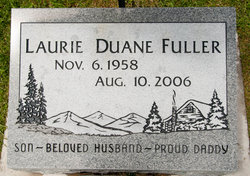
Laurie Duane Fuller
| Birth | : | 6 Nov 1958 |
| Death | : | 10 Aug 2006 Sacramento, Sacramento County, California, USA |
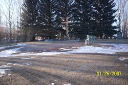
| Burial | : | St. Anne's Churchyard, Chapeltown, Blackburn with Darwen Unitary Authority, England |
| Coordinate | : | 53.6371710, -2.4030440 |
| Description | : | Laurie Duane Fuller, 47, died unexpectedly Aug. 10, 2006, at UC Davis Hospital in Sacramento, Calif. Duane was born Nov. 6, 1958, to the late Francis "Mick" and Lois "Meme" Fuller. He was raised in Anaconda and graduated from Anaconda High School in 1978. He participated in wrestling, cross-country and track. He was a four-year letterman in cross-country. He was also among the top 25 finishers for the state of Montana his senior year. He attended the College of Great Falls and Montana State University and earned a bachelor of science degree in occupational health and safety engineering from Columbia Southern University. In... Read More |
frequently asked questions (FAQ):
-
Where is Laurie Duane Fuller's memorial?
Laurie Duane Fuller's memorial is located at: St. Anne's Churchyard, Chapeltown, Blackburn with Darwen Unitary Authority, England.
-
When did Laurie Duane Fuller death?
Laurie Duane Fuller death on 10 Aug 2006 in Sacramento, Sacramento County, California, USA
-
Where are the coordinates of the Laurie Duane Fuller's memorial?
Latitude: 53.6371710
Longitude: -2.4030440
Family Members:
Parent

Siblings
Flowers:


Nearby Cemetories:
1. St. Anne's Churchyard
Chapeltown, Blackburn with Darwen Unitary Authority, England
Coordinate: 53.6371710, -2.4030440
2. Methodist Church Churchyard
Edgworth, Blackburn with Darwen Unitary Authority, England
Coordinate: 53.6424280, -2.3962830
3. Edgworth Congregational Chapelyard
Edgworth, Blackburn with Darwen Unitary Authority, England
Coordinate: 53.6476280, -2.3967210
4. Hawkshaw Methodist Church Cemetery
Hawkshaw, Metropolitan Borough of Bury, England
Coordinate: 53.6313490, -2.3674190
5. St Mary Churchyard
Hawkshaw, Metropolitan Borough of Bury, England
Coordinate: 53.6307270, -2.3636210
6. Christ Church Churchyard
Egerton, Metropolitan Borough of Bolton, England
Coordinate: 53.6237080, -2.4389210
7. Congregational Churchyard
Affetside, Metropolitan Borough of Bury, England
Coordinate: 53.6175200, -2.3705800
8. Tottington Road Methodist Church Churchyard
Harwood, Metropolitan Borough of Bolton, England
Coordinate: 53.6079190, -2.3904960
9. St. Maxentius Churchyard
Bradshaw, Metropolitan Borough of Bolton, England
Coordinate: 53.6056800, -2.4014800
10. Harwood Methodist Church Cemetery
Harwood, Metropolitan Borough of Bolton, England
Coordinate: 53.6028240, -2.3903990
11. Greenmount United Reformed Churchyard
Greenmount, Metropolitan Borough of Bury, England
Coordinate: 53.6254581, -2.3381465
12. St Paul Churchyard
Astley Bridge, Metropolitan Borough of Bolton, England
Coordinate: 53.5996230, -2.4314330
13. St Anne Churchyard
Tottington, Metropolitan Borough of Bury, England
Coordinate: 53.6161499, -2.3409030
14. Bolton Cemetery
Astley Bridge, Metropolitan Borough of Bolton, England
Coordinate: 53.5989150, -2.4370830
15. St. John's Churchyard
Tottington, Metropolitan Borough of Bury, England
Coordinate: 53.6141180, -2.3400670
16. Christ Church Churchyard
Harwood, Metropolitan Borough of Bolton, England
Coordinate: 53.5948860, -2.3821990
17. Emmanuel Churchyard
Holcombe, Metropolitan Borough of Bury, England
Coordinate: 53.6463000, -2.3293400
18. Ramsbottom Cemetery
Ramsbottom, Metropolitan Borough of Bury, England
Coordinate: 53.6372986, -2.3271000
19. St. Paul's Churchyard
Halliwell, Metropolitan Borough of Bolton, England
Coordinate: 53.5955450, -2.4475770
20. Darwen Eastern Cemetery
Darwen, Blackburn with Darwen Unitary Authority, England
Coordinate: 53.6769300, -2.4547700
21. Darwen Cemetery
Darwen, Blackburn with Darwen Unitary Authority, England
Coordinate: 53.6781400, -2.4598300
22. St Peter Churchyard
Belmont, Blackburn with Darwen Unitary Authority, England
Coordinate: 53.6379520, -2.4955480
23. Ainsworth Methodist Churchyard
Ainsworth, Metropolitan Borough of Bury, England
Coordinate: 53.5877390, -2.3623810
24. Belmont Congregational Churchyard
Belmont, Blackburn with Darwen Unitary Authority, England
Coordinate: 53.6419917, -2.4955512