
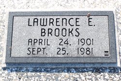
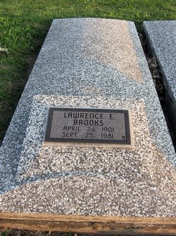
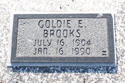
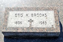
Lawrence E. Brooks
| Birth | : | 24 Apr 1901 Cabool, Texas County, Missouri, USA |
| Death | : | 25 Sep 1981 Pittsburg, Crawford County, Kansas, USA |
| Burial | : | Beaton Cemetery, Benton County, USA |
| Coordinate | : | 36.2677994, -88.0777969 |
frequently asked questions (FAQ):
-
Where is Lawrence E. Brooks's memorial?
Lawrence E. Brooks's memorial is located at: Beaton Cemetery, Benton County, USA.
-
When did Lawrence E. Brooks death?
Lawrence E. Brooks death on 25 Sep 1981 in Pittsburg, Crawford County, Kansas, USA
-
Where are the coordinates of the Lawrence E. Brooks's memorial?
Latitude: 36.2677994
Longitude: -88.0777969
Family Members:
Parent
Spouse
Siblings

Children
Flowers:


Nearby Cemetories:
1. Beaton Cemetery
Benton County, USA
Coordinate: 36.2677994, -88.0777969
2. Mount Vinson Cemetery
Big Sandy, Benton County, USA
Coordinate: 36.2732060, -88.0686740
3. Roney Cemetery
Big Sandy, Benton County, USA
Coordinate: 36.2762160, -88.0668460
4. Willow Cemetery
Big Sandy, Benton County, USA
Coordinate: 36.2548020, -88.0759660
5. Pleasant Ridge Cemetery
Big Sandy, Benton County, USA
Coordinate: 36.2630390, -88.0556540
6. Bucy Cemetery
Henry County, USA
Coordinate: 36.2860985, -88.1010971
7. Cooper Cemetery
Big Sandy, Benton County, USA
Coordinate: 36.2783480, -88.0462480
8. Edward Lindsey Cemetery
Big Sandy, Benton County, USA
Coordinate: 36.2401740, -88.0707360
9. Pierce Cemetery
Big Sandy, Benton County, USA
Coordinate: 36.2972060, -88.0789180
10. Richardson Cemetery
Big Sandy, Benton County, USA
Coordinate: 36.2346220, -88.0680200
11. Mount Carmel Congregational Methodist Church Cemet
Big Sandy, Benton County, USA
Coordinate: 36.2869850, -88.0377230
12. McRaes Chapel Cemetery
Big Sandy, Benton County, USA
Coordinate: 36.2187940, -88.0747570
13. Precinct Cemetery
Big Sandy, Benton County, USA
Coordinate: 36.3009500, -88.0284500
14. Craig - Farmer Family Cemetery
Henry County, USA
Coordinate: 36.2350006, -88.1292038
15. Medlock Cemetery
Big Sandy, Benton County, USA
Coordinate: 36.3210000, -88.0799320
16. Leegan Cemetery
Benton County, USA
Coordinate: 36.3292590, -88.0784920
17. Dortch Cemetery
Big Sandy, Benton County, USA
Coordinate: 36.3303010, -88.0764280
18. Lindsey Cemetery
Benton County, USA
Coordinate: 36.2655983, -87.9989014
19. Ramble Creek Cemetery
Big Sandy, Benton County, USA
Coordinate: 36.2036000, -88.0784750
20. Oak Hill Church Cemetery
Benton County, USA
Coordinate: 36.3325890, -88.0643370
21. Margaret McKenzie Brewer Cemetery
Big Sandy, Benton County, USA
Coordinate: 36.2028000, -88.0543000
22. Ellis Cemetery
Henry County, USA
Coordinate: 36.2789001, -88.1622009
23. Lick Creek Church Cemetery
Big Sandy, Benton County, USA
Coordinate: 36.3214910, -88.0213010
24. Bond-Limekiln Cemetery
Henry County, USA
Coordinate: 36.3367004, -88.0991974