Lawrence Patrick “Pat” Sullivan
| Birth | : | 28 Mar 1939 Dunlap, Harrison County, Iowa, USA |
| Death | : | 20 Sep 1969 |
| Burial | : | Pleasant Hill Cemetery, Dunlap, Harrison County, USA |
| Coordinate | : | 41.8446999, -95.5939026 |
| Plot | : | New Section, Block 4, Row 3 |
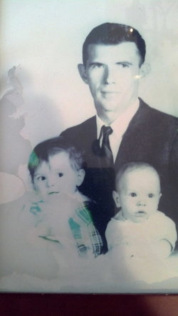
| Description | : | Fought in the Korean War. Killed in a car wreck in the 1970s while intoxicated - ran into a tree without wearing a seat belt. Pat drove a truck and, according to his Social Security records, married Chalie Ellis in 1965. She was hitchhiking and he picked her up at a truck stop in Wyoming. They had three children - 2 boys and a girl. Nanette was the oldest child born in 1965. According to Pat's cousin Gerald Patrick Sullivan, Pat was an over the road driver of a large semi. He was a drinker and a fighter.... Read More |
frequently asked questions (FAQ):
-
Where is Lawrence Patrick “Pat” Sullivan's memorial?
Lawrence Patrick “Pat” Sullivan's memorial is located at: Pleasant Hill Cemetery, Dunlap, Harrison County, USA.
-
When did Lawrence Patrick “Pat” Sullivan death?
Lawrence Patrick “Pat” Sullivan death on 20 Sep 1969 in
-
Where are the coordinates of the Lawrence Patrick “Pat” Sullivan's memorial?
Latitude: 41.8446999
Longitude: -95.5939026
Family Members:
Parent
Siblings
Flowers:
Nearby Cemetories:
1. Pleasant Hill Cemetery
Dunlap, Harrison County, USA
Coordinate: 41.8446999, -95.5939026
2. Valley View Cemetery
Crawford County, USA
Coordinate: 41.8647003, -95.6252975
3. Manteno Cemetery
Shelby County, USA
Coordinate: 41.8343964, -95.5367355
4. Doyle Cemetery
Earling, Shelby County, USA
Coordinate: 41.8051000, -95.5087000
5. Abel Galland Memorial Cemetery
Manteno, Shelby County, USA
Coordinate: 41.8370000, -95.4932500
6. Gallands Grove RLDS Holcomb Cemetery
Shelby County, USA
Coordinate: 41.8342018, -95.4788971
7. Dow City Cemetery
Dow City, Crawford County, USA
Coordinate: 41.9219017, -95.5119019
8. Woodbine Cemetery
Woodbine, Harrison County, USA
Coordinate: 41.7466316, -95.7143936
9. Butler Cemetery
Arion, Crawford County, USA
Coordinate: 41.9364014, -95.4627991
10. Washington Township Cemetery
Panama, Shelby County, USA
Coordinate: 41.7305984, -95.4867020
11. Saint Marys Cemetery
Panama, Shelby County, USA
Coordinate: 41.7332993, -95.4811020
12. Mefferd Cemetery
Harrison County, USA
Coordinate: 41.7132200, -95.6576200
13. Saint Joseph Cemetery
Earling, Shelby County, USA
Coordinate: 41.7797012, -95.4207993
14. Willow Township Cemetery
Charter Oak, Crawford County, USA
Coordinate: 41.9913776, -95.6141702
15. Benjamin Purcell Cemetery
Allen, Harrison County, USA
Coordinate: 41.7694328, -95.7794523
16. Cowan-Pardee Cemetery
Woodbine, Harrison County, USA
Coordinate: 41.6976500, -95.6765000
17. Crawford County Poor Farm Cemetery
Crawford County, USA
Coordinate: 41.9508216, -95.4308331
18. Buck Grove Cemetery
Buck Grove, Crawford County, USA
Coordinate: 41.9067841, -95.3839722
19. Soldier Lutheran Church Cemetery
Soldier, Monona County, USA
Coordinate: 41.9510000, -95.7800000
20. Old Norwegian Lutheran Cemetery
Soldier, Monona County, USA
Coordinate: 41.9460000, -95.7885000
21. Biglers Grove Cemetery
Woodbine, Harrison County, USA
Coordinate: 41.7327995, -95.7786026
22. Union Township Cemetery
Defiance, Shelby County, USA
Coordinate: 41.8269005, -95.3471985
23. Saints Peter and Paul Catholic Cemetery
Defiance, Shelby County, USA
Coordinate: 41.8269005, -95.3450012
24. Ellison Cemetery
Harrison County, USA
Coordinate: 41.6561012, -95.6260986

