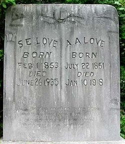
| Birth | : | 7 Jul 1818 London, Pope County, Arkansas, USA |
| Death | : | 8 Apr 1900 London, Pope County, Arkansas, USA |
| Burial | : | Burslem Cemetery, Burslem, Stoke-on-Trent Unitary Authority, England |
| Coordinate | : | 53.0463020, -2.1747030 |
| Description | : | Father: Robert Alexander Motley 1785-1854 Mother: Elizabeth Reed 1794-1851 Lear (also spelled Leah) was married to Pleasant Love. She was born in North Carolina to Robert and Elizabeth Reed Motley. Parent of Pleasant were: James Allison and Easter Carraker Love. Children of Pleasant and Lear Motley Love: 1. Martha Love born abt. 1836 in Carrabus County, NC; died Mar 14, 1916 in Pope County, Arkansas. 2. Julean Love born abt. 1839 3. Lavina Love born Feb. 25, 1840 in North Carolina. Married (1) John Smith (2) Littleton Crankfiend... Read More |
frequently asked questions (FAQ):
-
Where is Lear Motley Love's memorial?
Lear Motley Love's memorial is located at: Burslem Cemetery, Burslem, Stoke-on-Trent Unitary Authority, England.
-
When did Lear Motley Love death?
Lear Motley Love death on 8 Apr 1900 in London, Pope County, Arkansas, USA
-
Where are the coordinates of the Lear Motley Love's memorial?
Latitude: 53.0463020
Longitude: -2.1747030
Family Members:
Spouse
Children
Flowers:
Nearby Cemetories:
1. Burslem Cemetery
Burslem, Stoke-on-Trent Unitary Authority, England
Coordinate: 53.0463020, -2.1747030
2. Smallthorne Cemetery
Smallthorne, Stoke-on-Trent Unitary Authority, England
Coordinate: 53.0480310, -2.1765950
3. Parish church of st saviour smallthorne
Smallthorne, Stoke-on-Trent Unitary Authority, England
Coordinate: 53.0497445, -2.1758707
4. St John the Baptist Churchyard
Burslem, Stoke-on-Trent Unitary Authority, England
Coordinate: 53.0425850, -2.1962510
5. St Bartholomew Churchyard
Norton in the Moors, Stoke-on-Trent Unitary Authority, England
Coordinate: 53.0604630, -2.1595270
6. Holy Trinity Churchyard
Hanley, Stoke-on-Trent Unitary Authority, England
Coordinate: 53.0297350, -2.1672050
7. St. John the Evangelist Churchyard
Hanley, Stoke-on-Trent Unitary Authority, England
Coordinate: 53.0280200, -2.1749590
8. St. Philip and St. James Churchyard
Milton, Stoke-on-Trent Unitary Authority, England
Coordinate: 53.0503730, -2.1403780
9. Carmountside Cemetery and Crematorium
Milton, Stoke-on-Trent Unitary Authority, England
Coordinate: 53.0449570, -2.1394910
10. Sacred Heart Churchyard
Hanley, Stoke-on-Trent Unitary Authority, England
Coordinate: 53.0210590, -2.1737770
11. Christ Church Churchyard
Tunstall, Stoke-on-Trent Unitary Authority, England
Coordinate: 53.0625400, -2.2112840
12. St. Mark's Church Graveyard
Shelton, Stoke-on-Trent Unitary Authority, England
Coordinate: 53.0189000, -2.1820000
13. Etruria Methodist Church
Stoke-on-Trent, Stoke-on-Trent Unitary Authority, England
Coordinate: 53.0209680, -2.1985840
14. St. Mary's Churchyard
Bucknall, Stoke-on-Trent Unitary Authority, England
Coordinate: 53.0240220, -2.1424430
15. St Margaret Churchyard
Wolstanton, Newcastle-Under-Lyme Borough, England
Coordinate: 53.0296810, -2.2154990
16. Tunstall Cemetery
Tunstall, Stoke-on-Trent Unitary Authority, England
Coordinate: 53.0618690, -2.2180260
17. Hanley Cemetery
Hanley, Stoke-on-Trent Unitary Authority, England
Coordinate: 53.0143330, -2.1863120
18. Abbey of St Mary
Abbey Hulton, Stoke-on-Trent Unitary Authority, England
Coordinate: 53.0200000, -2.1300000
19. St. John the Evangelist Churchyard
Goldenhill, Stoke-on-Trent Unitary Authority, England
Coordinate: 53.0749010, -2.2189830
20. St Chad Churchyard
Bagnall, Staffordshire Moorlands District, England
Coordinate: 53.0558430, -2.1082770
21. St Anne Churchyard
Brown Edge, Staffordshire Moorlands District, England
Coordinate: 53.0832490, -2.1429880
22. Quakers Burial Ground
Stoke-on-Trent, Stoke-on-Trent Unitary Authority, England
Coordinate: 53.0052870, -2.1881570
23. St. Peter ad Vincula Churchyard
Stoke-on-Trent, Stoke-on-Trent Unitary Authority, England
Coordinate: 53.0041250, -2.1812460
24. St. George's Churchyard
Newcastle-under-Lyme, Newcastle-Under-Lyme Borough, England
Coordinate: 53.0141190, -2.2242070


